Browse All

1882 Brookville, Indiana. County Atlas Brookville. |

1882 Cedar Grove Formerly Rochester, Pepperto … County Atlas Cedar Grove Formerly Rochester, Pepperto … |

1882 Metamora Township, Franklin County, Indi … County Atlas Map of Metamora Township. Metamora. St. … |

1882 Brookville Township, Franklin County, In … County Atlas Map of Brookville Township, Franklin Cou … |

1882 Springfield Township, Franklin County, I … County Atlas Map of Springfield Township. |

1882 Bath Township and Fairfield Township, Fr … County Atlas Map of Bath Township. Map of Fairfield T … |

1882 Blooming Grove Township, Franklin County … County Atlas Map of Blooming Grove Township. Blooming … |

1882 Laurel Township, Franklin County, Indian … County Atlas Map of Laurel Township. |

1882 Posey Township, Franklin County, Indiana … County Atlas Map of Posey Township. Andersonville (Fo … |

1882 Laurel, Indiana. County Atlas Laurel. |

1882 Salt Creek Township, Franklin County, In … County Atlas Map of Salt Creek Township. |

1882 Ray Township. Oldenburg. Enochsburg. Hun … County Atlas Map of Ray Township. Oldenburg. Enochsbu … |

1882 Butler Township. County Atlas Map of Butler Township. |

1882 Highland Township. Village and Catholic … County Atlas Map of Highland Township. Village and Ca … |

1882 Map of White Water Township, Franklin Co … County Atlas Map of White Water Township. |
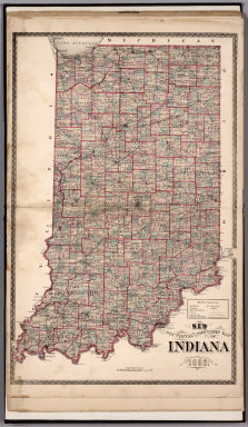
1882 Sectional and Township Map of Indiana. 1 … County Atlas Sectional and Township Map of Indiana. 1 … |

1882 New Railroad Map of the United States. County Atlas New Railroad Map of the United States. |

1882 Western Hemisphere. Eastern Hemisphere. County Atlas Western Hemisphere. Eastern Hemisphere. |