|
|
REFINE
Browse All : Images by John Melish
1-48 of 48
Author
Melish, John
Full Title
Map of the United States of America. Designed to Illustrate the Geological Memoir of Wm. Maclure Esqr. Entered as the Act directs, and Published by John Melish, Philadelphia. Transactions American Philosophical Society Vol. 1 New Series. (1824)
Publisher
John Melish
Author
Melish, John
Full Title
Map of the United States with the contiguous British & Spanish Possessions Compiled from the latest & best Authorities By John Melish. Engraved by J. Vallance & H.S. Tanner. Entered ... 6th day of June 1816. Published by John Melish Philadelphia. (inset) West Indies.
Publisher
John Melish
Author
Melish, John
Full Title
(Covers to) Information and Advice to Emigrants to the United States: and from the Eastern to the Western States: Illustrated by A Map of the United States, and A Chart of the Atlantic Ocean. By John Melish. Philadelphia: Printed for and Published by John Melish, No. 121, Chesnut Street. 1819. (on verso) ...on the nineteenth day of June ... 1819, John Melish ... hath deposited ... a book ... Pennsylvania.
Publisher
John Melish
Author
Melish, John
Full Title
United States...Improved to 1818
Publisher
John Melish
Author
Melish, John
Full Title
Chart of the Atlantic Ocean
Publisher
John Melish
Author
Melish, John
Full Title
(Covers to) Map of the United States with the contiguous British & Spanish Possessions Compiled from the latest & best Authorities By John Melish. Engraved by J. Vallance & H.S. Tanner. Entered ... 6th day of June 1816. Published by John Melish Philadelphia. (inset) West Indies.
Publisher
John Melish
Author
[Darby, William, Melish, John]
Full Title
A Map of the State of Louisiana With Part Of The Mississippi Territory, from Actual Survey By Wm. Darby. Entered ... 8th day of April 1816, by William Darby. Saml. Harrison Sct. Philad. Philadelphia, Published May the 1st 1816, by John Melish.
Publisher
John Melish
Author
Melish, John
Full Title
Map of the United States with the contiguous British & Spanish Possessions Compiled from the latest & best Authorities By John Melish. Engraved by J. Vallance & H.S. Tanner. Entered ... 6th day of June 1816. Published by John Melish Philadelphia. (inset) West Indies.
Publisher
John Melish
Author
Melish, John
Full Title
(Covers to) A Military and Topographical Atlas of the United States; including The British Possessions & Florida ... To Which Is Added, A List Of The Military Districts, A Register Of The Army, And A List Of The Navy Of The United States. By John Melish. Philadelphia, Printed By G. Palmer. November, 1813.
Publisher
John Melish
Author
Melish, John
Full Title
Map of the American Coast, from Lynhaven Bay to Narraganset Bay, by John Melish.
Publisher
John Melish
Author
Melish, John
Full Title
(Title Page to) A Military and Topographical Atlas of the United States; including The British Possessions & Florida ... To Which Is Added, A List Of The Military Districts, A Register Of The Army, And A List Of The Navy Of The United States. By John Melish. Philadelphia, Printed By G. Palmer. November, 1813.
Publisher
John Melish
Author
Melish, John
Full Title
Map of the Seat of War in North America. J. Melish del. H.S. Tanner, Dirext. Entered as the Art Directs, and Published by John Melish, Philadelphia.
Publisher
John Melish
Author
Melish, John
Full Title
View of the Country round the Falls of Niagara.
Publisher
John Melish
Author
Melish, John
Full Title
East End of Lake Ontario.
Publisher
John Melish
Author
Melish, John
Full Title
Plan of Montreal, with a Map of the Islands & adjoining Country.
Publisher
John Melish
Author
Melish, John
Full Title
Southern Section of the United States including Florida &c. by John Melish. Entered ... by John Melish ... 1 March 1813.
Publisher
John Melish
Author
Melish, John
Full Title
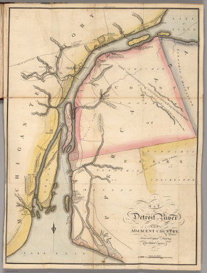
Map of Detroit River and Adjacent Country, From an Original Drawing, by a British Engineer.
Publisher
John Melish
Author
Melish, John
Full Title
Plan of Quebec and Adjacent Country Shewing The principal Encampments & Works of the British & French Armies during the Siege by General Wolfe in 1759. Reduced from the M.S.S. Map of Capt. J.B. Glegg, by John Melish.
Publisher
John Melish
Author
Melish, John
Full Title
Map of Illinois Constructed from the Surveys in the General Land Office and other Documents By John Melish. Saml. Harrison, sct. Entered according to Act of Congress the 16th day of April 1818. Philadelphia. Published by John Melish. Improved to 1820.
Publisher
John Melish
Author
Melish, John
Full Title
Map of Pennsylvania. Constructed from the County Surveys authorized by the State and other original Documents by John Melish. Engraved by B. Tanner. Entered ... 7th day of June 1822, by John Melish ... Pennsylvania. (title engravng) Drawn by F. Kearny. Engraved by B. Tanner.
Publisher
John Melish
Author
Melish, John
Full Title
(Covers to) Melish's Universal School Atlas. Philadelphia, Published 1816. Improved to 1820. S. Harrison, Sc.
Publisher
John Melish
Author
Melish, John
Full Title
(Title Page to) Melish's Universal School Atlas. Philadelphia, Published 1816. Improved to 1820. S. Harrison, Sc.
Publisher
John Melish
Author
Melish, John
Full Title
Elementary Map. Published 1st June 1816 by J. Melish, Philadelphia. H.S. Tanner sc.
Publisher
John Melish
Author
Melish, John
Full Title
Map of the World from the latest discoveries. No. II. Saml. Harrison sct. Published 1st Sepr. 1816 by J. Melish, Philadelphia. Improved to 1820.
Publisher
John Melish
Author
Melish, John
Full Title
The World on Mercator's Projection; with all the latest Discoveries. H.S. Tanner sc. Published 1st June 1816 by J. Melish, Philadelphia. Improved to 1820.
Publisher
John Melish
Author
Melish, John
Full Title
America. No. IV. (Published 1st June 1816 by J. Melish. Philadelphia. Improved to 1820.)
Publisher
John Melish
Author
Melish, John
Full Title
Europe. No. V. Published 1st June 1816 by J. Melish. Philadelphia. Improved to 1820. J. Vallance sculp.
Publisher
John Melish
Author
Melish, John
Full Title
Asia &c. No. VII. (Published 1st June 1816 by J. Melish. Philadelphia. Improved to 1820.) H.S. Tanner Sc.
Publisher
John Melish
Author
Melish, John
Full Title
Africa. No. VI. (Published 1st June 1816 by J. Melish. Philadelphia. Improved to 1820.) J. Vallance sculp.
Publisher
John Melish
Author
Melish, John
Full Title
United States. No. VIII. Published 1st June 1816 by J. Melish. Philadelphia. Improved to 1820. J. Melish del.
Publisher
John Melish
Author
Melish, John
Full Title
(Covers to) The traveller's directory through the United States; containing, a description of all the principal roads through the United States ... The whole illustrated by appropriate maps. By John Melish. Philadelphia: Published by the Author. 1822. (on verso) ...on the eighteenth day of September ... 1821, John Melish ... has deposited ... a book ... Pennsylvania.
Publisher
John Melish
Author
Melish, John
Full Title
(Title Page to) The traveller's directory through the United States; containing, a description of all the principal roads through the United States ... The whole illustrated by appropriate maps. By John Melish. Philadelphia: Published by the Author. 1822. (on verso) ...on the eighteenth day of September ... 1821, John Melish ... has deposited ... a book ... Pennsylvania.
Publisher
John Melish
Author
Melish, John
Full Title
United States of America. Compiled from the latest & best authorities by John Melish, 1820. Engraved by Saml. Harrison. Entered ... 10th July 1818, and published by John Melish, Philadelphia, improved to 1822.
Publisher
John Melish
Author
Melish, John
Full Title
A diagram of the United States shewing the bearings and distances of the principal places from Washington, and from each other, with a scale of time. Prepared for the Travellers directory by John Melish. (Philadelphia: Published by the Author. 1822)
Publisher
John Melish
Author
Melish, John
Full Title
(Covers to) A Military and Topographical Atlas of the United States; Including The British Possessions & Florida ... By John Melish. Philadelphia, Published By John Melish. G. Palmer Printer 1815. (on verso) District of Pennsylvania ... fourteenth day of March ... 1815 ... John Melish ... hath deposited ... a book.
Publisher
John Melish
Author
Melish, John
Full Title
(Title Page to) A Military and Topographical Atlas of the United States; Including The British Possessions & Florida ... By John Melish. Philadelphia, Published By John Melish. G. Palmer Printer 1815. (on verso) District of Pennsylvania ... fourteenth day of March ... 1815 ... John Melish ... hath deposited ... a book.
Publisher
John Melish
Author
Melish, John
Full Title
Map of the Seat of War in North America. J. Melish del. H.S. Tanner, Dirext. Entered as the Art Directs, and Published by John Melish, Philadelphia.
Publisher
John Melish
Author
Melish, John
Full Title
View of the Country round the Falls of Niagara.
Publisher
John Melish
Author
Melish, John
Full Title
East End of Lake Ontario.
Publisher
John Melish
Author
Melish, John
Full Title
Plan of Montreal, with a Map of the Islands & adjoining Country.
Publisher
John Melish
Author
Melish, John
Full Title
Southern Section of the United States including Florida &c. by John Melish. 1816. Entered ... by John Melish ... 1 March 1813. Improved nth. June 1816.
Publisher
John Melish
Author
Melish, John
Full Title
Map of the American Coast, from Lynhaven Bay to Narraganset Bay, by John Melish.
Publisher
John Melish
Author
Melish, John
Full Title
Map of Detroit River and Adjacent Country, From an Original Drawing, by a British Engineer.
Publisher
John Melish
Author
Melish, John
Full Title
Plan of Quebec and Adjacent Country Shewing The principal Encampments & Works of the British & French Armies during the Siege by General Wolfe in 1759. Reduced from the M.S.S. Map of Capt. J.B. Glegg, by John Melish.
Publisher
John Melish
Author
Melish, John
Full Title
East End of Lake Ontario and River St. Lawrence From Kingston to French Mills Reduced from an Original Drawing in the Naval Department by John Melish.
Publisher
John Melish
Author
Melish, John
Full Title
Map of the River St. Lawrence and Adjacent Country From Williamsburg to Montreal from and Original Drawing in the War Department.
Publisher
John Melish
Author
Melish, John
Full Title
Map of the Seat of War among the Creek Indians From the Original Drawing in the War Department.
Publisher
John Melish
1-48 of 48
|