Who What Where WhenREMOVE |
REFINE
Browse All : Atlas Map by John Melish
1-29 of 29
Author
Melish, John
Full Title
Map of the United States of America. Designed to Illustrate the Geological Memoir of Wm. Maclure Esqr. Entered as the Act directs, and Published by John Melish, Philadelphia. Transactions American Philosophical Society Vol. 1 New Series. (1824)
Publisher
John Melish
Author
Melish, John
Full Title
Map of the American Coast, from Lynhaven Bay to Narraganset Bay, by John Melish.
Publisher
John Melish
Author
Melish, John
Full Title
Map of the Seat of War in North America. J. Melish del. H.S. Tanner, Dirext. Entered as the Art Directs, and Published by John Melish, Philadelphia.
Publisher
John Melish
Author
Melish, John
Full Title
View of the Country round the Falls of Niagara.
Publisher
John Melish
Author
Melish, John
Full Title
East End of Lake Ontario.
Publisher
John Melish
Author
Melish, John
Full Title
Plan of Montreal, with a Map of the Islands & adjoining Country.
Publisher
John Melish
Author
Melish, John
Full Title
Southern Section of the United States including Florida &c. by John Melish. Entered ... by John Melish ... 1 March 1813.
Publisher
John Melish
Author
Melish, John
Full Title
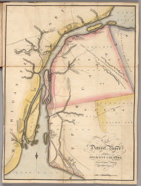
Map of Detroit River and Adjacent Country, From an Original Drawing, by a British Engineer.
Publisher
John Melish
Author
Melish, John
Full Title
Plan of Quebec and Adjacent Country Shewing The principal Encampments & Works of the British & French Armies during the Siege by General Wolfe in 1759. Reduced from the M.S.S. Map of Capt. J.B. Glegg, by John Melish.
Publisher
John Melish
Author
Melish, John
Full Title
Elementary Map. Published 1st June 1816 by J. Melish, Philadelphia. H.S. Tanner sc.
Publisher
John Melish
Author
Melish, John
Full Title
Map of the World from the latest discoveries. No. II. Saml. Harrison sct. Published 1st Sepr. 1816 by J. Melish, Philadelphia. Improved to 1820.
Publisher
John Melish
Author
Melish, John
Full Title
The World on Mercator's Projection; with all the latest Discoveries. H.S. Tanner sc. Published 1st June 1816 by J. Melish, Philadelphia. Improved to 1820.
Publisher
John Melish
Author
Melish, John
Full Title
America. No. IV. (Published 1st June 1816 by J. Melish. Philadelphia. Improved to 1820.)
Publisher
John Melish
Author
Melish, John
Full Title
Europe. No. V. Published 1st June 1816 by J. Melish. Philadelphia. Improved to 1820. J. Vallance sculp.
Publisher
John Melish
Author
Melish, John
Full Title
Asia &c. No. VII. (Published 1st June 1816 by J. Melish. Philadelphia. Improved to 1820.) H.S. Tanner Sc.
Publisher
John Melish
Author
Melish, John
Full Title
Africa. No. VI. (Published 1st June 1816 by J. Melish. Philadelphia. Improved to 1820.) J. Vallance sculp.
Publisher
John Melish
Author
Melish, John
Full Title
United States. No. VIII. Published 1st June 1816 by J. Melish. Philadelphia. Improved to 1820. J. Melish del.
Publisher
John Melish
Author
Melish, John
Full Title
Map of the Seat of War in North America. J. Melish del. H.S. Tanner, Dirext. Entered as the Art Directs, and Published by John Melish, Philadelphia.
Publisher
John Melish
Author
Melish, John
Full Title
View of the Country round the Falls of Niagara.
Publisher
John Melish
Author
Melish, John
Full Title
East End of Lake Ontario.
Publisher
John Melish
Author
Melish, John
Full Title
Plan of Montreal, with a Map of the Islands & adjoining Country.
Publisher
John Melish
Author
Melish, John
Full Title
Southern Section of the United States including Florida &c. by John Melish. 1816. Entered ... by John Melish ... 1 March 1813. Improved nth. June 1816.
Publisher
John Melish
Author
Melish, John
Full Title
Map of the American Coast, from Lynhaven Bay to Narraganset Bay, by John Melish.
Publisher
John Melish
Author
Melish, John
Full Title
Map of Detroit River and Adjacent Country, From an Original Drawing, by a British Engineer.
Publisher
John Melish
Author
Melish, John
Full Title
Plan of Quebec and Adjacent Country Shewing The principal Encampments & Works of the British & French Armies during the Siege by General Wolfe in 1759. Reduced from the M.S.S. Map of Capt. J.B. Glegg, by John Melish.
Publisher
John Melish
Author
Melish, John
Full Title
East End of Lake Ontario and River St. Lawrence From Kingston to French Mills Reduced from an Original Drawing in the Naval Department by John Melish.
Publisher
John Melish
Author
Melish, John
Full Title
Map of the River St. Lawrence and Adjacent Country From Williamsburg to Montreal from and Original Drawing in the War Department.
Publisher
John Melish
Author
Melish, John
Full Title
Map of the Seat of War among the Creek Indians From the Original Drawing in the War Department.
Publisher
John Melish
1-29 of 29
|