Browse All

1882 Covers: North Carolina Pocket Map (Covers to) Map Of North Carolina, By W. … |

1882 North Carolina Pocket Map Map Of North Carolina, By W.C. Kerr, Sta … |

1882 Territory Of Dakota. 1882 Separate Map Department Of The Interior General Land … |

1883 Territory Of Arizona. 1883 Separate Map Department Of The Interior General Land … |

1883 Washington Territory. 1883 Separate Map Department Of The Interior General Land … |

1890 Map Of Indian Territory And Oklahoma Separate Map Map Of Indian Territory And Oklahoma. 18 … |

1887 Territory Of Arizona, 1887 Separate Map Department Of The Interior General Land … |

1882 Map of the Washoe District Showing Minin … Geologic Atlas Map of the Washoe District Showing Minin … |

1882 Geological Map of the Washoe District. Geologic Atlas Geological Map of the Washoe District. U … |

1882 Vertical Cross Sections of the Lode. Geologic Atlas Vertical Cross Sections of the Lode. Uni … |

1882 Vertical Cross Sections of the Lode. Geologic Atlas Vertical Cross Sections of the Lode. Uni … |

1882 Vertical Cross Sections of the Lode. Geologic Atlas Vertical Cross Sections of the Lode. Uni … |

1882 Horizontal Section of the Comstock Lode … Geologic Atlas Horizontal Section of the Comstock Lode … |

1882 Horizontal Section of the Comstock Lode … Geologic Atlas Horizontal Section of the Comstock Lode … |

1882 Longitudinal Vertical Projection of the … Geologic Atlas Longitudinal Vertical Projection of the … |

1882 Longitudinal Vertical Projection of the … Geologic Atlas Longitudinal Vertical Projection of the … |

1882 Longitudinal Vertical Projection of the … Geologic Atlas Longitudinal Vertical Projection of the … |

1882 Comstock Mine Maps. Number I. Geologic Atlas Comstock Mine Maps. Number I. United Sta … |

1882 Comstock Mine Maps. Number II. Geologic Atlas Comstock Mine Maps. Number II. United St … |

1882 Comstock Mine Maps. Number III. Geologic Atlas Comstock Mine Maps. Number III. United S … |

1882 Comstock Mine Maps. Number IV. Geologic Atlas Comstock Mine Maps. Number IV. United St … |

1882 Comstock Mine Maps. Number V. Geologic Atlas Comstock Mine Maps. Number V. United Sta … |

1882 Comstock Mine Maps. Number VI. Geologic Atlas Comstock Mine Maps. Number VI. United St … |

1882 Comstock Mine Maps. Number VII. Geologic Atlas Comstock Mine Maps. Number VII. United S … |

1882 Comstock Mine Maps. Number VIII. Geologic Atlas Comstock Mine Maps. Number VIII. United … |

1882 Comstock Mine Maps. Number VIX. Geologic Atlas Comstock Mine Maps. Number VIX. United S … |

1882 Cover: Geology, Comstock Lode, Washoe Di … Geologic Atlas (Covers to) Department Of The Interior, … |

1882 Title Page: Geology of the Comstock Lode … Geologic Atlas (Title Page to) Department Of The Interi … |

1882 Index: Geology, Comstock Lode, Washoe Di … Geologic Atlas (Index to) Department Of The Interior, U … |

1883 Territory Of Idaho. 1883 Separate Map Department Of The Interior General Land … |

1895 Ft. Moultrie, Ft. Johnson, Morris I., Cu … Military Atlas Fort Moultrie as seen from Fort Sumter, … |

1895 Cumming's Pt. batteries, works. Military Atlas Appearance of the batteries on Cumming's … |

1895 Bull Run, Manassas. Military Atlas Plan of the battle-field at Bull Run, Ju … |

1895 Charleston defenses, Belmont battlefield … Military Atlas Map of the defenses of Charleston City a … |

1895 Youngs Branch; Columbus, Ky. Military Atlas Battle-field of Youngs Branch or Manassa … |

1895 Defenses Washington. Military Atlas Defenses of Washington. Map of the groun … |

1895 N.E. Virginia, Washington 1. Military Atlas Surveys for military defenses. Map of no … |
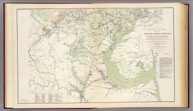
1895 N.E. Virginia, Washington 2. Military Atlas Surveys for military defenses. Map of no … |

1895 Valverde, Shiloh, Ft. Craig, Roanoke Isl … Military Atlas Engagement at Valverde, N.M., February 2 … |

1895 Monterey, Tenn.-Corinth, Miss. Military Atlas Map of the country between Monterey, Ten … |

1895 Siege of Yorktown. Military Atlas Reconnaissance of secession works and pl … |

1895 Yorktown, Gloucester, Va. Military Atlas Reconnaissance of the secession works at … |

1895 SE Virginia, Ft. Monroe. Military Atlas Part of the map of the Military Departme … |

1895 SE Virginia, Ft. Monroe, approaches to R … Military Atlas Part of the map of the Military Departme … |

1895 Dept. of Virginia, Yorktown to Williamsb … Military Atlas Copy of a map. Sheet no. 1 military reco … |

1895 White House-Harrison's Landing. Military Atlas Campaign maps, Army of the Potomac. Map … |

1895 Battle-grounds Richmond, Va. Military Atlas Map of the Battle-grounds in the vicinit … |

1895 Hanover, Hanover C.H., New Bridge, Mecha … Military Atlas Rough sketch of reconnaissance, May 24th … |

1895 Cav. Brigade, Cedar Mtn., Manassas, Bull … Military Atlas Map of the operations of the Cavalry Bri … |

1895 1st Corps Army of Virginia; Secessionvil … Military Atlas Map of route and positions, First Corps, … |