Who What Where WhenREMOVEWHERE
|
REFINE
Browse All : Atlas Map and Geologic Atlas by Julius Bien
1-42 of 42
Author
King, Clarence
Full Title
Cordilleras.
Publisher
Julius Bien
Author
[Blaskowitz, Charles, Grant, James, Holland, Samuel, 1728-1801, Sproule, George, Wheeler, Thomas, Wright, Thomas]
Full Title
A topographical map of the State of New Hampshire, surveyed under the direction of Samuel Holland Esqr., Surveyor General of Lands for the Northern District of North America by the following gentlemen his deputies, Mr. Thomas Wright, Mr. George Sproule, Mr. James Grant, Mr. Thomas Wheeler & Mr. Charles Blaskowitz. London. printed for William Faden, Geographer to the King, Charing-Cross, March 1st, 1784. (New York: Julius Bien, 1878)
Publisher
Julius Bien
Author
Carrigain, Philip
Full Title
Map of New Hampshire by Philip Carrigain. 1816. (New York: Julius Bien, 1878)
Publisher
Julius Bien
Author
[Hitchcock, Charles H. (Charles Henry), 1836-1919, New Hampshire. Geological Survey]
Full Title
(General geological map of New Hampshire, embracing portions of Maine, Vermont, and Quebec. Sheet 1. Julius Bien, New York, 1878)
Publisher
Julius Bien
Author
[Hitchcock, Charles H. (Charles Henry), 1836-1919, New Hampshire. Geological Survey]
Full Title
(General geological map of New Hampshire, embracing portions of Maine, Vermont, and Quebec. Sheet 2. Julius Bien, New York, 1878)
Publisher
Julius Bien
Author
[Hitchcock, Charles H. (Charles Henry), 1836-1919, New Hampshire. Geological Survey]
Full Title
(General geological map of New Hampshire, embracing portions of Maine, Vermont, and Quebec. Sheet 3. Julius Bien, New York, 1878)
Publisher
Julius Bien
Author
[Hitchcock, Charles H. (Charles Henry), 1836-1919, New Hampshire. Geological Survey]
Full Title
(General geological map of New Hampshire, embracing portions of Maine, Vermont, and Quebec. Sheet 4. Julius Bien, New York, 1878)
Publisher
Julius Bien
Author
[Hitchcock, Charles H. (Charles Henry), 1836-1919, New Hampshire. Geological Survey]
Full Title
(General geological map of New Hampshire, embracing portions of Maine, Vermont, and Quebec. Sheet 5. Julius Bien, New York, 1878)
Publisher
Julius Bien
Author
[Hitchcock, Charles H. (Charles Henry), 1836-1919, New Hampshire. Geological Survey]
Full Title
(General geological map of New Hampshire, embracing portions of Maine, Vermont, and Quebec. Sheet 6. Julius Bien, New York, 1878)
Publisher
Julius Bien
Author
[Hitchcock, Charles H. (Charles Henry), 1836-1919, New Hampshire. Geological Survey]
Full Title
(Composite of General geological map of New Hampshire, embracing portions of Maine, Vermont, and Quebec. Julius Bien, New York, 1878)
Publisher
Julius Bien
Author
[Hitchcock, Charles H. (Charles Henry), 1836-1919, New Hampshire. Geological Survey]
Full Title
(Topographic and glacial feature map of New Hampshire. Sheet 1. Julius Bien, New York, 1878)
Publisher
Julius Bien
Author
[Hitchcock, Charles H. (Charles Henry), 1836-1919, New Hampshire. Geological Survey]
Full Title
(Topographic and glacial feature map of New Hampshire. Sheet 2. Julius Bien, New York, 1878)
Publisher
Julius Bien
Author
[Hitchcock, Charles H. (Charles Henry), 1836-1919, New Hampshire. Geological Survey]
Full Title
(Topographic and glacial feature map of New Hampshire. Sheet 3. Julius Bien, New York, 1878)
Publisher
Julius Bien
Author
[Hitchcock, Charles H. (Charles Henry), 1836-1919, New Hampshire. Geological Survey]
Full Title
(Topographic and glacial feature map of New Hampshire. Sheet 4. Julius Bien, New York, 1878)
Publisher
Julius Bien
Author
[Hitchcock, Charles H. (Charles Henry), 1836-1919, New Hampshire. Geological Survey]
Full Title
(Topographic and glacial feature map of New Hampshire. Sheet 5. Julius Bien, New York, 1878)
Publisher
Julius Bien
Author
[Hitchcock, Charles H. (Charles Henry), 1836-1919, New Hampshire. Geological Survey]
Full Title
Map of the Ammonoosuc Mining District. (Julius Bien, New York, 1878) The Heliotype Printing Co. 220 Devonshire St., Boston.
Publisher
Julius Bien
Author
[Bishop, F. M., De Motte, B. C., Geological and Geographical Survey of the Territories (U.S.), Powell, John Wesley, 1834-1902, Thompson, A. H. (Almon Harris), 1839-1906]
Full Title
Green River from the Union Pacific Rail Road to the mouth of White River, 1873 (land cover). Department of the Interior. U.S. Geological and Geographical Survey of the Territories. Second Division. J.W. Powell, geologist in charge, A.H. Thompson, geographer, B.C. De Motte & F.M. Bishop, topographers. W.H. Graves del. Outlines engraved by S.J. Kubel. U.S. G. and G. Survey, 2d. Div. ... Geology of the Unita Mountains. (Julius Bien Lith.)
Publisher
Julius Bien
Author
[Bishop, F. M., De Motte, B. C., Geological and Geographical Survey of the Territories (U.S.), Powell, John Wesley, 1834-1902, Thompson, A. H. (Almon Harris), 1839-1906]
Full Title
Green River from the Union Pacific Rail Road to the mouth of White River, 1873 (geology). Department of the Interior. U.S. Geological and Geographical Survey of the Territories. Second Division. J.W. Powell, geologist in charge, A.H. Thompson, geographer, B.C. De Motte & F.M. Bishop, topographers. W.H. Graves del. Outlines engraved by S.J. Kubel. U.S. G. and G. Survey, 2d. Div. ... Geology of the Unita Mountains. (Julius Bien Lith.)
Publisher
Julius Bien
Author
[Geological and Geographical Survey of the Territories (U.S.), Powell, John Wesley, 1834-1902]
Full Title
Structure sections through the Uinta Mountains. U.S. G. and G. Survey, 2d. Div., J.W. Powell, geologist in charge. Geology of the Unita Mountains. (Julius Bien Lith.)
Publisher
Julius Bien
Author
[Geological and Geographical Survey of the Territories (U.S.), Powell, John Wesley, 1834-1902]
Full Title
Displacement diagrams derived from the Structure sections through the Uinta Mountains, pl. I. U.S. G. and G. Survey, 2d. Div., J.W. Powell, geologist in charge. Geology of the Unita Mountains. (Julius Bien Lith.)
Publisher
Julius Bien
Author
[Geological and Geographical Survey of the Territories (U.S.), Powell, John Wesley, 1834-1902]
Full Title
Stereogram of the displacements of the eastern portion of the Uinta Mountains. U.S. G. and G. Survey, 2d. Div., J.W. Powell, geologist in charge. Geology of the Unita Mountains. (Julius Bien Lith.)
Publisher
Julius Bien
Author
[Geological and Geographical Survey of the Territories (U.S.), Gilbert, Grove Karl, 1843-1918, Powell, John Wesley, 1834-1902]
Full Title
Bird's-eye view of a part of the Uinta Uplift. Designed by G.K. Gilbert. U.S. G. and G. Survey, 2d. Div., J.W. Powell, geologist in charge. Geology of the Unita Mountains. (Julius Bien Lith.)
Publisher
Julius Bien
Author
[Geological and Geographical Survey of the Territories (U.S.), Powell, John Wesley, 1834-1902]
Full Title
Stereogram of the displacements of the Yampa Plateau. U.S. G. and G. Survey, 2d. Div., J.W. Powell, geologist in charge. Geology of the Unita Mountains. (Julius Bien Lith.)
Publisher
Julius Bien
Author
[Geological and Geographical Survey of the Territories (U.S.), Marvine, Archibald Robertson, 1848-1876, Powell, John Wesley, 1834-1902]
Full Title
No. 1. Structure section through the Aspen Mountain Uplift. No. 2. Displacement diagram derived from the above section. (with) Generalized structure section through the Park Mountains. By Archibald R. Marvine. U.S. G. and G. Survey, 2d. Div., J.W. Powell, geologist in charge. Geology of the Unita Mountains. (Julius Bien Lith.)
Publisher
Julius Bien
Author
King, Clarence
Full Title
Plate 1. Part of the U.S. Engineer Department's Map of the Western States and Territories, Showing Location of Mining Districts.
Publisher
Julius Bien
Author
King, Clarence
Full Title
Plate 2. Geological Map of the Washoe Mining District, Geology: C. King. Topography: J.T. Gardner.
Publisher
Julius Bien
Author
King, Clarence
Full Title
Plate 3. Horizontal Map Gold Hill Mines Workings, Comstock Lode.
Publisher
Julius Bien
Author
King, Clarence
Full Title
Plate 4. Horizontal Map Virginia Mines Workings, Comstock Lode.
Publisher
Julius Bien
Author
King, Clarence
Full Title
Plate 13. Geological Map of the Toyabe (Toiyabe) Mountains. Geology: S.F. Emmons. Topography: A.D. Wilson.
Publisher
Julius Bien
Author
King, Clarence
Full Title
Plate 14. Geological Map of the White Pine Mining District. Geology: A. Hague. Topography: F.A. Clark.
Publisher
Julius Bien
Author
King, Clarence
Full Title
Plate 5. Horizontal Map North Virginia Mines Workings, Comstock Lode.
Publisher
Julius Bien
Author
King, Clarence
Full Title
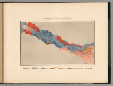
Rocky Mountains. Map I. (Geological)
Publisher
Julius Bien
Author
King, Clarence
Full Title
Green River Basin. Map II. (Geological)
Publisher
Julius Bien
Author
King, Clarence
Full Title
Utah Basin. Map III. (Geological)
Publisher
Julius Bien
Author
King, Clarence
Full Title
Nevada Plateau. Map IV. (Geological)
Publisher
Julius Bien
Author
King, Clarence
Full Title
Nevada Basin. Map V. (Geological)
Publisher
Julius Bien
Author
King, Clarence
Full Title
General Sections.
Publisher
Julius Bien
Author
King, Clarence
Full Title
Rocky Mountains. Map I. (Topographical)
Publisher
Julius Bien
Author
King, Clarence
Full Title
Green River Basin. Map II. (Topographical)
Publisher
Julius Bien
Author
King, Clarence
Full Title
Utah Basin. Map III. (Topographical)
Publisher
Julius Bien
Author
King, Clarence
Full Title
Nevada Plateau. Map IV. (Topographical)
Publisher
Julius Bien
1-42 of 42
|