Browse All

1868 A Portion of the Sierra Nevada adjacent … Guide Book Map of a Portion of the Sierra Nevada ad … |

1876 Cordilleras. Geologic Atlas Cordilleras. |

1878 A topographical map of the State of New … Geologic Atlas A topographical map of the State of New … |

1878 Map of New Hampshire. 1816. Geologic Atlas Map of New Hampshire by Philip Carrigain … |

1878 (General geological map of New Hampshire … Geologic Atlas (General geological map of New Hampshire … |

1878 (General geological map of New Hampshire … Geologic Atlas (General geological map of New Hampshire … |

1878 (General geological map of New Hampshire … Geologic Atlas (General geological map of New Hampshire … |

1878 (General geological map of New Hampshire … Geologic Atlas (General geological map of New Hampshire … |

1878 (General geological map of New Hampshire … Geologic Atlas (General geological map of New Hampshire … |

1878 (General geological map of New Hampshire … Geologic Atlas (General geological map of New Hampshire … |

1878 Composite: New Hampshire general geologi … Geologic Atlas (Composite of General geological map of … |

1878 (Topographic and glacial feature map of … Geologic Atlas (Topographic and glacial feature map of … |

1878 (Topographic and glacial feature map of … Geologic Atlas (Topographic and glacial feature map of … |

1878 (Topographic and glacial feature map of … Geologic Atlas (Topographic and glacial feature map of … |

1878 (Topographic and glacial feature map of … Geologic Atlas (Topographic and glacial feature map of … |

1878 (Topographic and glacial feature map of … Geologic Atlas (Topographic and glacial feature map of … |

1878 Map of the Ammonoosuc Mining District. Geologic Atlas Map of the Ammonoosuc Mining District. ( … |

1884 Position of the Forest, Prairie and Tree … Physical Atlas Map Showing the Position of the Forest, … |

1884 Natural Divisions of the North American … Physical Atlas Map Showing the Natural Divisions of the … |

1884 Distribution of Genus Fraxinus [The Ashe … Physical Atlas Map Showing the Distribution of Genus Fr … |

1884 Distribution of the Genera Carya & Umbel … Physical Atlas Map Showing the Distribution of the Gene … |

1884 Distribution of the Genus Juglans [The W … Physical Atlas Map Showing the Distribution of the Genu … |

1884 Distribution of the Genus Quercus [The O … Physical Atlas Map Showing the Distribution of the Genu … |

1884 Distribution of the Genera Castanea & Ca … Physical Atlas Map Showing the Distribution of the Gene … |

1884 Distribution of the Genus Pinus [The Pin … Physical Atlas Map Showing the Distribution of the Genu … |

1884 Distribution of the Genus Abies & Picea … Physical Atlas Map Showing the Distribution of the Genu … |

1884 Distribution of Liriodendron Tulipifera … Physical Atlas Map Showing the Distribution of Lirioden … |

1884 Distribution of Prosopsis Juliflora, Que … Physical Atlas Map Showing the Distribution of Prosopsi … |

1884 Distribution of Fraxinus Americana & Pin … Physical Atlas Map Showing the Distribution of Fraxinus … |

1884 Distribution of the Genera Chamaecyparis … Physical Atlas Map Showing the Distribution of the Gene … |

1884 Distribution of the Genera Thuya, Taxodi … Physical Atlas Map Showing the Distribution of the Gene … |

1884 Distribution of Pinus Strobus, P. (Pinus … Physical Atlas Map Showing the Distribution of Pinus St … |
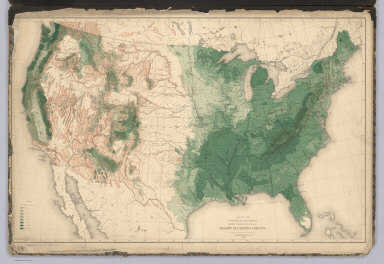
1884 United States showing the Relative Avera … Physical Atlas Map of the United States showing the Rel … |

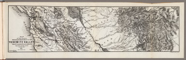
1868 Yosemite Valley. Guide Book Map of the Yosemite Valley, from Surveys … |

1868 A Portion of the Sierra Nevada adjacent … Guide Book Map of a Portion of the Sierra Nevada ad … |

1870 A Portion of the Sierra Nevada adjacent … Guide Book Map of a Portion of the Sierra Nevada ad … |
1871 Routes from San Francisco to the Yosemit … Guide Book Map of the Routes from San Francisco to … |

1871 Yosemite Valley. Guide Book Map of the Yosemite Valley, prepared to … |

1876 Green River from the Union Pacific Rail … Geologic Atlas Green River from the Union Pacific Rail … |

1876 Green River from the Union Pacific Rail … Geologic Atlas Green River from the Union Pacific Rail … |

1876 Structure sections through the Uinta Mou … Geologic Atlas Structure sections through the Uinta Mou … |

1876 Displacement diagrams ... through the Ui … Geologic Atlas Displacement diagrams derived from the S … |

1876 Stereogram of the displacements of the U … Geologic Atlas Stereogram of the displacements of the e … |

1876 Bird's-eye view of a part of the Uinta U … Geologic Atlas Bird's-eye view of a part of the Uinta U … |

1876 Stereogram of the displacements of the U … Geologic Atlas Stereogram of the displacements of the Y … |

1876 Structure sections, displacement diagram … Geologic Atlas No. 1. Structure section through the Asp … |

1879 Bird's eye view of the Black Hills to il … [Exploration Book, Regional Atlas] Bird's eye view of the Black Hills to il … |

1879 Map of the Black Hills of Dakota. [Exploration Book, Regional Atlas] Map of the Black Hills of Dakota, from e … |

1879 Geological map of the Black Hills of Dak … [Exploration Book, Regional Atlas] Geological map of the Black Hills of Dak … |

1870 Plate 1. Part of the U.S. Engineer Depar … Geologic Atlas Plate 1. Part of the U.S. Engineer Depar … |