Who What Where When |
Author
Bache, A. D.
Full Title
Nantucket Harbor. From a trigonometrical survey under the direction of A.D. Bache, Superintendent of the Survey of the Coast of the United States. Triangulation by A.D. Bache and C.M. Eakin assistant. Topography by H.L. Whiting assistant. Hydrography by the party under the command of C.H. Davis Lieutenant, U.S. Navy. Published in 1848. Reduction by J.M. Wampler, draughtsman. Views by J. Robertson. Engraving of topography by F. Dankworth & O.A. Lawson, assisted by J.H. Young. Views by A.O. Lawson. Lettering by J. Knight & W. Smith. Printed by H. Benner. Electrotype copy no. 1 by G. Mathiot, U.S.C.S. (with logo) U.S. Coast Survey Office.
Publisher
U.S.
Author
[Bache, A. D., Hassler, F. R.]
Full Title
General chart of the coast from Gay Head to Cape Henlopen. From a trigonometrical survey under the direction of F.R. Hassler and A.D. Bache, Superintendents of the Survey of the Coast of the United States. Published in 1852. A.D. Bache, Superintendent. Reduction for engraving by J. Farley asst., W.M.C. Fairfax asst., C. Mahon, J.J. Ricketts & J. Lambert draughtsmen. Views by J. Farley asst. Topography engraved by F. Dankworth & O.A. Lawson. Lettering by John Knight. Views by O.A. Lawson. Soundings by J. Knight & W. Smith. Sections by G. McCoy & O.A. Lawson. Electrotype copy no. 2 by G. Mathiot, U.S.C.S. (with logo) U.S. Coast Survey Office.
Publisher
U.S.
Author
[Bache, A. D., Hassler, F. R.]
Full Title
The Harbor of New London. Founded upon a trigonometrical survey under the direction of F.R. Hassler, Superintendent of the Survey of the Coast of the United States. Triangulation by E. Blunt assistant. Topography by F.H. Gerdes and J.B. Gluck assistants. Hydrography by the party under the command of G.S. Blake, Lieutenant, U.S. Navy. Published in 1848. A.D. Bache, Superintendent. Final reduction for engraving by J.B. Gluck, draughtsman. Topography engraved by A. Rolle. Lettering by J. Knight. Electrotyped by S. Siebert. Printed by H. Benner. Electrotype copy no. 2 by G. Mathiot, U.S.C.S. (with logo) U.S. Coast Survey Depot.
Publisher
U.S.
Author
[Bache, A. D., Hassler, F. R.]
Full Title
Harbors of Black Rock and Bridgeport. Founded upon a trigonometrical survey under the direction of F.R. Hassler, Superintendent of the Survey of the Coast of the United States. Triangulation by J. Ferguson, assistant. Topography by C.M. Eakin. Hydrography by the party under the command of Lieutenant G.S. Blake, U.S. Navy. Published in 1848. A.D. Bache, Superintendent. Reduction for engraving by M.I. McClery, assistant, with some additions by J.M. Wampler, draughtsman. Topography engraved by S.T. Pettit, apprentice, finished by F. Dankworth, O.A. Lawson & A. Rolle. Lettering by F. Dankworth and J. Knight. Electrotype copy no. 1 by G. Mathiot, U.S.C.S. (with logo) U.S. Coast Survey Office.
Publisher
U.S.
Author
[Bache, A. D., Hassler, F. R.]
Full Title
Hell Gate and its approaches. From a trigonometrical survey under the direction of F.R. Hassler and A.D. Bache, Superintendents of the Survey of the Coast of the United States. Triangulation by Edmund Blunt, assistant. Topography by H.L. Whiting, assistant. Hydrography by the parties under the command of D.D. Porter & M. Woodhull, Lts., U.S. Navy. Published in 1851. A.D. Bache, Superintendent. Reduction of topography for engraving by C. Mahon, of hydrography by J.R.P. Mechlin. Topography engraved by A. Rolle, F. Dankworth & G. McCoy; lettering by J. Knight. Electrotype copy no. 1 by G. Mathiot, U.S.C.S. (with logo) U.S. Coast Survey Office.
Publisher
U.S.
Author
[Bache, A. D., Hassler, F. R.]
Full Title
Map of New-York Bay and Harbor and the environs. From a trigonometrical survey under the direction of F.R. Hassler, Superintendent of the Survey of the Coast of the United States. Triangulation by James Ferguson and Edmund Blunt, assistants. The hydrography under the direction of Thomas R. Gedney, Lieutenant, U.S. Navy. The topography by C. Renard, T.A. Jenkins & B.F. Sands, assists. Published in 1845. A.D. Bache, Superintendent. Topography engraved by S. Siebert & A. Rolle, views engraved by O.A. Lawson. Engraving supervised & views of the coast drawn by J. Farley. Hydrography engraved by F. Dankworth, lettering by F. Dankworth & J. Knight. Electrotype copy no. 5 by G. Mathiot, U.S.C.S. (with logo) U.S. Coast Survey Depot.
Publisher
U.S.
Author
[Bache, A. D., Hassler, F. R.]
Full Title
Little Egg Harbor. Founded upon a trigonometrical survey under the direction of F.R. Hassler, Superintendent of the Survey of the Coast of the United States. Triangulation by C. Renard, assistant. Topography by G.M. Bache & B.F. Sands, U.S.N. & C. Renard, assistant. Hydrography by G.M. Bache, Lieut., U.S. Navy. Published in 1846. A.D. Bache, Superintendent. Final reduction for engraving by M.I. McClery, draughtsman. Topography engd. by O.A. Lawson, & lettering by J. Knight. Printed by H. Benner. (with logo) U.S. Coast Survey Depot.
Publisher
U.S.
Author
Bache, A. D.
Full Title
Cat and Ship Island harbors. From a trigonometrical survey under the direction of A.D. Bache, Superintendent of the Survey of the Coast of the United States. Main triangulation by F.H. Gerdes, assistant. Secondary triangulation by J.E. Hilgard, assistant. Topography by W.E. Greenwell, assistant. Hydrography by the party under the command of C.P. Patterson, Lieut. U.S. Navy. Published in 1850. Reduction for engraving by Chas. Mahon, draughtsman. Engraved by Sherman & Smith, N.Y. Title & sailing directions &c. by J. Knight U.S.C.S. Electrotype copy no. 1 by G. Mathiot, U.S.C.S. (with logo) U.S. Coast Survey Office.
Publisher
U.S.
Author
Mitchell, Samuel Augustus
Full Title
A New Map of the World on the Globular Projection. Philadelphia, Published By S. Augustus Mitchell. N.E. corner of Market & 7th. Streets.
Publisher
S.A. Mitchell
Author
Mitchell, Samuel Augustus
Full Title
North America. Philadelphia, Published By S. Augustus Mitchell. N.E. corner of Market & 7th. Streets.
Publisher
S.A. Mitchell
Author
Mitchell, Samuel Augustus
Full Title
Canada East Formerly Lower Canada. Published By S. Augustus Mitchell. N.E. corner of Market & 7th. Streets Philada. (inset map) Nova Scotia New Brunswick & c.
Publisher
S.A. Mitchell
Author
Mitchell, Samuel Augustus
Full Title
Canada West Formerly Upper Canada. Published By S. Augustus Mitchell. N.E. corner of Market & 7th. Streets. (inset) Untitled map of Lake Superior.
Publisher
S.A. Mitchell
Author
Mitchell, Samuel Augustus
Full Title
United States.
Publisher
S.A. Mitchell
Author
Mitchell, Samuel Augustus
Full Title
A New Map of Maine. Published By S. Augustus Mitchell. N.E. corner of Market & 7th. Streets. Philada. 1848
Publisher
S.A. Mitchell
Author
Mitchell, Samuel Augustus
Full Title
New Hampshire & Vermont. Published By S. Augustus Mitchell. N.E. corner of Market & 7th. Streets. Philadelphia.
Publisher
S.A. Mitchell
Author
Mitchell, Samuel Augustus
Full Title
Massachusetts & Rhode Island: Published By S. Augustus Mitchell. N.E. corner of Market & 7th. Streets. Philadelphia. (inset map) Boston.
Publisher
S.A. Mitchell
Author
Mitchell, Samuel Augustus
Full Title
Connecticut. Published By S. Augustus Mitchell. N.E. corner of Market & 7th. Streets. Philadelphia. (inset map) Hartford &c. and New Haven &c.
Publisher
S.A. Mitchell
Author
Mitchell, Samuel Augustus
Full Title
A New Map of New York, with its Canals, Roads & Distances. Published By S. Augustus Mitchell. N.E. corner of Market & 7th. Streets. Philadelphia.
Publisher
S.A. Mitchell
Author
Mitchell, Samuel Augustus
Full Title
City of New York. Published By S. Augustus Mitchell. N.E. corner of Market & 7th. Streets. Philada.
Publisher
S.A. Mitchell
Author
Mitchell, Samuel Augustus
Full Title
New Jersey, Reduced from T. Gordon's Map by H.S. Tanner. Published By S. Augustus Mitchell. N.E. corner of Market & 7th. Streets. Philada. 1848. Entered ... 1834 by T. Gordon ... New Jersey.
Publisher
S.A. Mitchell
Author
Mitchell, Samuel Augustus
Full Title
A New Map of Pennsylvania with its Canals, Rail-Roads &c. Published By S. Augustus Mitchell. N.E. corner of Market & 7th. Streets. Philada. (inset) Profile of the Pennsylvania Canal.
Publisher
S.A. Mitchell
Author
Mitchell, Samuel Augustus
Full Title
Philadelphia.
Publisher
S.A. Mitchell
Author
Mitchell, Samuel Augustus
Full Title
A New Map of Maryland and Delaware, with their Canals, Roads & Distances. Published By S. Augustus Mitchell. N.E. corner of Market & 7th. Streets. Philadelphia. (inset map) Baltimore.
Publisher
S.A. Mitchell
Author
Mitchell, Samuel Augustus
Full Title
City of Washington. Published By S. Augustus Mitchell. N.E. corner of Market & 7th. Streets. Philada. (inset) Plan of the principal floor of Capital.
Publisher
S.A. Mitchell
Author
Mitchell, Samuel Augustus
Full Title
A New Map of Virginia with its Canals, Roads & Distances from Place to Place along the stage & steam boat Routes. Published By S. Augustus Mitchell. N.E. corner of Market & 7th. Streets. Philadelphia. (inset) Profile of the Chesapeake & Ohio Canal.
Publisher
S.A. Mitchell
Author
Mitchell, Samuel Augustus
Full Title
A New Map of Nth. Carolina with its Canals, Roads & Distances from Place to Place along the Stage & Steam Boat Routes. Published By S. Augustus Mitchell. N.E. corner of Market & 7th. Streets. Philadelphia. (2 inset maps & 1 profile) Gold Region, the Newbern Region, and Profile of the Dismal Swamp Canal.
Publisher
S.A. Mitchell
Author
Mitchell, Samuel Augustus
Full Title
A New Map of South Carolina with its Canals, Roads & Distances from Place to Place along the Stage & Steam Boat Routes. Published By S. Augustus Mitchell. N.E. corner of Market & 7th. Streets. Philadelphia. (inset map) Charleston.
Publisher
S.A. Mitchell
Author
Mitchell, Samuel Augustus
Full Title
A New Map of Georgia with its Canals, Roads & Distances from Place to Place along the Stage & Steam Boat Routes. Published By S. Augustus Mitchell. N.E. corner of Market & 7th. Streets. Philadelphia.
Publisher
S.A. Mitchell
Author
Mitchell, Samuel Augustus
Full Title
Florida. Published By S. Augustus Mitchell. N.E. corner of Market & 7th. Streets. Philadelphia. (3 inset maps) Pensacola. Tallahassee. Harbor of St. Augustine.
Publisher
S.A. Mitchell
Author
Mitchell, Samuel Augustus
Full Title
A New Map of Alabama with its Roads & Distances from Place to Place along the Stage & Steam Boat Routes. Published By S. Augustus Mitchell. N.E. corner of Market & 7th. Streets. Philadelphia.
Publisher
S.A. Mitchell
Author
Mitchell, Samuel Augustus
Full Title
A New Map of Mississippi with its Roads & Distances. Published By S. Augustus Mitchell. N.E. corner of Market & 7th. Streets. Philada. 1849.
Publisher
S.A. Mitchell
Author
Mitchell, Samuel Augustus
Full Title
A New Map of Louisiana with its Canals, Roads & Distances from Place to Place along the Stage & Steam Boat Routes. Published By S. Augustus Mitchell. N.E. corner of Market & 7th. Streets. Philada. (inset map) New Orleans.
Publisher
S.A. Mitchell
Author
Mitchell, Samuel Augustus
Full Title
A New Map of Arkansas with its Canals, Roads & Distances. Published By S. Augustus Mitchell. N.E. corner of Market & 7th. Streets. Philadelphia.
Publisher
S.A. Mitchell
Author
Mitchell, Samuel Augustus
Full Title
A New Map of Tennessee with its Canals, Roads & Distances from Place to Place along the Stage & Steam Boat Routes. Published By S. Augustus Mitchell. N.E. corner of Market & 7th. Streets. Philadelphia. (2 inset maps) Environs of Nashville. Environs of Knoxville.
Publisher
S.A. Mitchell
Author
Mitchell, Samuel Augustus
Full Title
A New Map of Kentucky with its Roads & Distances from Place to Place along the Stage & Steam Boat Routes. Published By S. Augustus Mitchell. N.E. corner of Market & 7th. Streets. Philadelphia. (3 inset maps) Falls of Ohio. Untitled maps of Fayette, Wood Ford and portion of bourbon Counties, and Ohio River.
Publisher
S.A. Mitchell
Author
Mitchell, Samuel Augustus
Full Title
A New Map of Ohio with its Canals, Roads & Distances. Published By S. Augustus Mitchell. N.E. corner of Market & 7th. Streets. Philadelphia. (inset) Profile of the Ohio Canal.
Publisher
S.A. Mitchell
Author
Mitchell, Samuel Augustus
Full Title
A New Map of Michigan with its Canals, Roads & Distances. Published By S. Augustus Mitchell. N.E. corner of Market & 7th. Streets. Philadelphia. (inset map) Western Part of Michigan.
Publisher
S.A. Mitchell
Author
Mitchell, Samuel Augustus
Full Title
A New Map of Indiana with its Roads & Distances. Published By S. Augustus Mitchell. N.E. corner of Market & 7th. Streets. Philadelphia. (inset) Profile of the Wabash and Erie Canal.
Publisher
S.A. Mitchell
Author
Mitchell, Samuel Augustus
Full Title
A New Map of Illinois with its Proposed Canals, Roads & Distances from Place to Place along the Stage & Steam Boat Routes. Published By S. Augustus Mitchell. N.E. corner of Market & 7th. Streets. Philadelphia. (inset map) Lead Region.
Publisher
S.A. Mitchell
Author
Mitchell, Samuel Augustus
Full Title
Map of Missouri. Published By S. Augustus Mitchell. N.E. corner of Market & 7th. Streets. Philada. Entered ... 1847 by H.N. Burroughs ... Pennsylvania.
Publisher
S.A. Mitchell
Author
Mitchell, Samuel Augustus
Full Title
Map of Wisconsin. Published By S. Augustus Mitchell. N.E. corner of Market & 7th. Streets. Philadelphia.
Publisher
S.A. Mitchell
Author
Mitchell, Samuel Augustus
Full Title
Iowa. Published By S. Augustus Mitchell. N.E. corner of Market & 7th. Streets. Philadelphia.
Publisher
S.A. Mitchell
Author
Mitchell, Samuel Augustus
Full Title
Map of Texas from the most Recent Authorities. Philadelphia: Published By C.S. Williams, N.E. corner of Market & 7th. Streets. Entered ... 1845 by C.S. Williams ... Pennsylvania. (inset map) Texas North of Red River.
Publisher
S.A. Mitchell
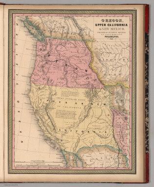
Author
Mitchell, Samuel Augustus
Full Title
Oregon, Upper California & New Mexico. Published By S. Augustus Mitchell. N.E. corner of Market & 7th. Sts. Philadelphia. 1849. Entered ... 1845 by H.N. Burroughs ... Penna.
Publisher
S.A. Mitchell
Author
Mitchell, Samuel Augustus
Full Title
Mexico & Guatemala: Published By S. Augustus Mitchell. N.E. corner of Market & 7th. Streets. Philadelphia. (2 inset maps) Valley of Mexico, and Guatemala.
Publisher
S.A. Mitchell
Author
Mitchell, Samuel Augustus
Full Title
West Indies.
Publisher
S.A. Mitchell
Author
Mitchell, Samuel Augustus
Full Title
South America.
Publisher
S.A. Mitchell
Author
Mitchell, Samuel Augustus
Full Title
Venezuela, New Grenada & Equador. (inset map) Plan of a Proposal Communication Between Atlantic & Pacific Oceans.
Publisher
S.A. Mitchell
Author
Mitchell, Samuel Augustus
Full Title
Brazil. (2 inset maps) Paraguay and Environs of Rio Janeiro.
Publisher
S.A. Mitchell
|