Who What Where WhenREMOVEWHERE
|
Author
Melish, John
Full Title
(Covers to) A General Collection Of Maps, Charts, Views, &c. ... Philadelphia. 1824.
Publisher
No publisher.
Author
Melish, John
Full Title
(Title Page to) A General Collection Of Maps, Charts, Views, &c. ... Philadelphia. 1824.
Publisher
No publisher.
Author
Melish, John
Full Title
A Map of the World from the Best Authorities. Western Hemisphere. Eastern Hemisphere. Thackara & Vallance. (1824)
Publisher
No publisher.
Author
Melish, John
Full Title
Part of North of Europe. (1824)
Publisher
No publisher.
Author
Melish, John
Full Title
Map of the United States of America. Designed to Illustrate the Geological Memoir of Wm. Maclure Esqr. Entered as the Act directs, and Published by John Melish, Philadelphia. Transactions American Philosophical Society Vol. 1 New Series. (1824)
Publisher
John Melish
Author
Melish, John
Full Title
Map of New Orleans and Adjacent Country by John Melish 1815.
Publisher
No publisher.
Author
Melish, John
Full Title
Jamaica. (1824)
Publisher
No publisher.
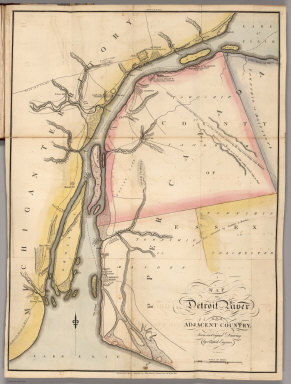
Author
Melish, John
Full Title
Map of Detroit River and Adjacent Country. Fro the Original Drawing by a British Engineer. H.S. Tanner. Entered as the Act Directs. (1824)
Publisher
No publisher.
Author
Melish, John
Full Title
Lakes of Mexico. Front. Vol. II. A. Lawson Sculpt. (1824)
Publisher
No publisher.
Author
Melish, John
Full Title
Anahuac, or the Empire of Mexico, the Kingdoms of Acolhuacan & Michuacan &c as they were in the year 1521. Front. Vol I. A. Lawson, sculp. Front .Vol.I. (1824)
Publisher
No publisher.
Author
Melish, John
Full Title
Greece. (1824)
Publisher
No publisher.
Author
Melish, John
Full Title
Switzerland. Engraved by J. Warr, Jr. (1824)
Publisher
No publisher.
Author
Melish, John
Full Title
Italy. Engraved by J. Warr, Jr. (1824)
Publisher
No publisher.
Author
Melish, John
Full Title
Map of the Course fo the Rhine, in the Environs of Strasbourg Showing the Passage of the Rhine effected by the Army of the Rhine & Moselle. & of the Operations at the Siege of Kehl. J. Bower, Sc. (1824)
Publisher
No publisher.
Author
Melish, John
Full Title
Map of Abyssinia. Copied from the Original Published by Henry Salt, Esqr. Bower, Sc. (1824)
Publisher
No publisher.
Author
Melish, John
Full Title
Bataille de Mont Saint Jean. Ordre de bataille des 2 armees francaise et angle-hollandaise a 10 heurs du matin. (1824)
Publisher
No publisher.
Author
Melish, John
Full Title
Map of Albania. (1824)
Publisher
No publisher.
Author
Melish, John
Full Title
A Map of the Vendee, South of the Loire and North of Brittany North of that River. The Vendon was was carried on both sides of the Loire 1793-4.... (1824)
Publisher
No publisher.
Author
Melish, John
Full Title
A General Chart Showing the Track and Discoveries of H.M. Ships Isabella & Alexander to Davis's Straits & Baffin Islands Bay in an Attempt to Discover a Passage into the Pacific Ocean. Commanded by Capn. Ross R.N. Drawn under his Inspection by J. Bushman, Midn. R.N. (1824)
Publisher
No publisher.
Author
Melish, John
Full Title
The Seven United Provinces of Holland, Groningen, Gelders, Friesland, Overyessel, Utrecht, and Zealand from the Best Authorities. C. Tiebout, Scl. N. York. (1824)
Publisher
No publisher.
Author
Melish, John
Full Title
Sweden, Denmark, Norway, and Finland from the Best Authorities. Engrav'd by S. Hill. Boston. (1824)
Publisher
No publisher.
Author
Melish, John
Full Title
Map of the Country belonging to the Cherokee and Creek Indians From the Original Drawing in the War Department. J. Melish del. (1824)
Publisher
No publisher.
Author
Melish, John
Full Title
Plan of Quebec and Adjacent Country Shewing the Principal Encampments and Works of the British & French Armies during the Siege by General Wolfe in 1759. Reduced fro the M.S.S. Map of Capt. J.B. Glegg by John Melish. Engd. by H.S. Tanner. (1824)
Publisher
No publisher.
Author
Melish, John
Full Title
East End of Lake Ontario and River St. Lawrence from Kingston to French Mills. Reduced from an Original Drawing in the Naval Department by John Melish. H.S. Tanner, Sc. (1824)
Publisher
No publisher.
Author
Melish, John
Full Title
Map of the St. Lawrence and Adjacent Country from Williamsburg to Montreal from an Original Drawing in the War Department. John Melish, del. H.S. Tanner, sc. (1824)
Publisher
No publisher.
Author
Melish, John
Full Title
Chart of the Atlantic Ocean. John Melish, del. Thackara Sculp. (1824)
Publisher
No publisher.
Author
Melish, John
Full Title
Sketch of the Countries Situated between Shiraz and Constantinople; Shewing the Route of His Majesty's Mission under Sir Harford Jones Bart. in 1809, from Bushire to Teheran; and of Mr. Morier from thence to Constantinople. As also the Route of Col. Malcolm in 1801. By J. Rennell. J. Bower, Sc. (1824)
Publisher
No publisher.
Author
Melish, John
Full Title
Sketch of the Action on the Heights of Charlestown (Boston), June 17th 1775, between His Majesty's Troops, under the command of Genl. Howe, and a large body of American Rebels. Copied by I.A. Chapman, from an original Sketch, taken by Henry De Berniere of the 14th Regiment of Infantry, now in the hands of J. Cist Esq. Engraved by Kneass, Young & Co. for the Analeche Magazine. Published by M. Thomas Philada. (1824)
Publisher
M. Thomas.
Author
Melish, John
Full Title
Map of the United States with the contiguous British & Spanish Possessions Compiled from the latest & best Authorities By John Melish. Engraved by J. Vallance & H.S. Tanner. Entered ... 6th day of June 1816. Published by John Melish Philadelphia. (inset) West Indies.
Publisher
John Melish
Author
Melish, John
Full Title
(Covers to) Information and Advice to Emigrants to the United States: and from the Eastern to the Western States: Illustrated by A Map of the United States, and A Chart of the Atlantic Ocean. By John Melish. Philadelphia: Printed for and Published by John Melish, No. 121, Chesnut Street. 1819. (on verso) ...on the nineteenth day of June ... 1819, John Melish ... hath deposited ... a book ... Pennsylvania.
Publisher
John Melish
Author
Melish, John
Full Title
United States...Improved to 1818
Publisher
John Melish
Author
Melish, John
Full Title
Chart of the Atlantic Ocean
Publisher
John Melish
Author
Melish, John
Full Title
(Composite of) Map of the United States with the contiguous British & Spanish Possessions Compiled from the latest & best Authorities By John Melish. Engraved by J. Vallance & H.S. Tanner. Entered ... 16th day of June 1820. Published by James Finlayson Agent Philada. Successor to John Melish, Improved to 1823. (inset) West Indies.
Publisher
James Finlayson
Author
Melish, John
Full Title
(Covers to) Map of the United States with the contiguous British & Spanish Possessions Compiled from the latest & best Authorities By John Melish. Engraved by J. Vallance & H.S. Tanner. Entered ... 6th day of June 1816. Published by John Melish Philadelphia. (inset) West Indies.
Publisher
John Melish
Author
[Darby, William, Melish, John]
Full Title
A Map of the State of Louisiana With Part Of The Mississippi Territory, from Actual Survey By Wm. Darby. Entered ... 8th day of April 1816, by William Darby. Saml. Harrison Sct. Philad. Philadelphia, Published May the 1st 1816, by John Melish.
Publisher
John Melish
Author
Melish, John
Full Title
Map of the United States with the contiguous British & Spanish Possessions Compiled from the latest & best Authorities By John Melish. Engraved by J. Vallance & H.S. Tanner. Entered ... 6th day of June 1816. Published by John Melish Philadelphia. (inset) West Indies.
Publisher
John Melish
Author
Melish, John
Full Title
(Covers to) A Military and Topographical Atlas of the United States; including The British Possessions & Florida ... To Which Is Added, A List Of The Military Districts, A Register Of The Army, And A List Of The Navy Of The United States. By John Melish. Philadelphia, Printed By G. Palmer. November, 1813.
Publisher
John Melish
Author
Melish, John
Full Title
Map of the American Coast, from Lynhaven Bay to Narraganset Bay, by John Melish.
Publisher
John Melish
Author
Melish, John
Full Title
(Title Page to) A Military and Topographical Atlas of the United States; including The British Possessions & Florida ... To Which Is Added, A List Of The Military Districts, A Register Of The Army, And A List Of The Navy Of The United States. By John Melish. Philadelphia, Printed By G. Palmer. November, 1813.
Publisher
John Melish
Author
Melish, John
Full Title
Map of the Seat of War in North America. J. Melish del. H.S. Tanner, Dirext. Entered as the Art Directs, and Published by John Melish, Philadelphia.
Publisher
John Melish
Author
Melish, John
Full Title
View of the Country round the Falls of Niagara.
Publisher
John Melish
Author
Melish, John
Full Title
East End of Lake Ontario.
Publisher
John Melish
Author
Melish, John
Full Title
Plan of Montreal, with a Map of the Islands & adjoining Country.
Publisher
John Melish
Author
Melish, John
Full Title
Southern Section of the United States including Florida &c. by John Melish. Entered ... by John Melish ... 1 March 1813.
Publisher
John Melish
Author
Melish, John
Full Title
Map of Detroit River and Adjacent Country, From an Original Drawing, by a British Engineer.
Publisher
John Melish
Author
Melish, John
Full Title
Plan of Quebec and Adjacent Country Shewing The principal Encampments & Works of the British & French Armies during the Siege by General Wolfe in 1759. Reduced from the M.S.S. Map of Capt. J.B. Glegg, by John Melish.
Publisher
John Melish
Author
Melish, John
Full Title
(Covers to) (Untitled Atlas of 12 Outline and Keyed Maps).
Publisher
(John Melish)
Author
Melish, John
Full Title
A: (Untitled landform map).
Publisher
(John Melish)
Author
Melish, John
Full Title
B: (Untitled outline map of the World).
Publisher
(John Melish)
|