Browse All

1841 Harbours in Admiralty Inlet, Washington. Chart Map Harbours in Admiralty Inlet, Oregon Terr … |

1840 Admiralty Inlet, Washington. Chart Map Ports Orchard and Madison including the … |

1841 (Nanumanga), Maraki Island, Maiana Islan … Chart Map Hudson's Island (Nanumanga), by the U.S. … |
1840 Island of Yendua, Nucumurry Harbour, Wai … Chart Map Island of Yendua, Feejee (Fiji) Group, b … |

1841 Apia or Charlotte Island, Tarawa or Knox … Chart Map Apia or Charlotte Island, Kingsmill Grou … |

1841 (Hereheretue Atoll), (Nukutepipi), (Anua … Chart Map St. Pablo (Hereheretue Atoll), Paumotu G … |

1841 Disappointment Group, Serle (Pukaruha or … Chart Map Disappointment Group, by the U.S.Ex.Ex. … |

1841 Eastern Group, Sheet 1, Feejee (Fiji) Is … Chart Map Eastern Group, Sheet 1, Feejee (Fiji) Is … |

1841 Eastern Group, Sheet 2, Feejee (Fiji) Is … Chart Map Eastern Group, Sheet 2, Feejee (Fiji) Is … |

1841 Island of Ovolau (Ovalau), Feejee (Fiji) … Chart Map Island of Ovolau (Ovalau), Feejee (Fiji) … |

1841 Makatea Island, Tauere, Takurea or Wolco … Chart Map Metia (Makatea) Island, Paumotu Group by … |

1841 Kawahe (Kauehi)or Vincennes Island, Rara … Chart Map Kawahe (Kauehi)or Vincennes Island, Paum … |

1841 Port Safety, Island of Kea (Kioa); Fawn … Chart Map Port Safety, Island of Kea (Kioa), East … |

1839 Islands of Manua (Manu'a), Ofoo (Ofu), O … Chart Map Islands of Manua (Manu'a), Ofoo (Ofu) & … |

1841 Funafuti or Ellices Island, Nukufetau or … Chart Map Funafuti or Ellices Island, by the U.S.E … |

1841 Tatara or King's Island,Henuake, Honden, … Chart Map Tatara or King's Island, by the U.S.Ex.E … |

1841 Hawaiian Group or Sandwich Islands. Chart Map Map of Hawaiian Group or Sandwich Island … |

1841 Deans, Krusensterns, and Lazareff Island … Chart Map Deans, Krusensterns, and Lazareff Island … |

1841 North Side of Vanu Levu from Aramula Pas … Chart Map Channel on the North Side of Vanu Levu f … |

1841 New Dunginess Roads and Budds Harbour (S … Chart Map New Dunginess Roads and Budds Harbour, S … |

1841 Grays Harbour, Oregon Territory (Washing … Chart Map Grays Harbour, Oregon Territory by the U … |
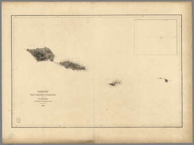
1841 Samoan or Navigator Islands. Chart Map Samoan or Navigator Islands by the U.S. … |

1841 Harbour of Pago Pago, Island of Tutuila. Chart Map Harbour of Pago Pago, Island of Tutuila … |

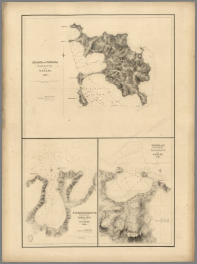
1841 Port Ludlow, Port Gamble, Hoods Canal, O … Chart Map Port Ludlow, Hoods Canal, Oregon Territo … |

1841 St. Juan Harbour, Straits of Fuca, Vanco … Chart Map St. Juan Harbour, Straits of Fuca, Vanco … |

1841 Channel of the North Side of Vanua Levu … Chart Map Channel of the North Side of Vanua Levu … |

1841 Scabock (Seabeck) Harbour, Hooetzen Harb … Chart Map Scabock Harbour, Hoods Canal, Oregon Ter … |