Who What Where WhenREMOVE |
REFINE
Browse All : Chart Map and Oceans/Seas by Sherman & Smith
1-27 of 27
Author
[Wilkes, Charles, United States Exploring Expedition]
Full Title
Harbours in Admiralty Inlet, Oregon Territory by the U.S.Ex.Ex. 1841.
Publisher
C. Sherman
Author
[Wilkes, Charles, United States Exploring Expedition]
Full Title
Ports Orchard and Madison including the Inlets and Passages between them in Admiralty Inlet, Oregon Territory, by the U.S.Ex.Ex. 1840.
Publisher
C. Sherman
Author
[Wilkes, Charles, United States Exploring Expedition]
Full Title
Hudson's Island (Nanumanga), by the U.S.Ex.Ex. 1841. Maraki or Matthews Island, Kingsmill Group, by the U.S.Ex.Ex. 1841. Maiana or Hall's Island, Kingsmill Group, by the U.S.Ex.Ex. 1841. Apamama or Hoppers Island, Kingsmill Group, by the U.S.Ex.Ex. 1841. Kuria and Nanouki Islands, Kingsmill Group, by the U.S.Ex.Ex. 1841.
Publisher
C. Sherman
Author
[Wilkes, Charles, United States Exploring Expedition]
Full Title
Island of Yendua, Feejee (Fiji) Group, by the U.S.Ex.Ex. 1840. Nucumurry Harbour, West End of Vanua Levu, by the U.S.Ex.Ex. 1840. Wailea Bay, North Side of Vanua Levu, by the U.S.Ex.Ex. 1840.
Publisher
C. Sherman
Author
[Wilkes, Charles, United States Exploring Expedition]
Full Title
Apia or Charlotte Island, Kingsmill Group, by the U.S.Ex.Ex. 1841. Tarawa or Knox Island, Kingsmill Group, by the U.S.Ex.Ex. 1841.
Publisher
C. Sherman
Author
[Wilkes, Charles, United States Exploring Expedition]
Full Title
St. Pablo (Hereheretue Atoll), Paumotu Group, by the U.S.Ex.Ex. 1841. Nukutipipi (Nukutepipi) or Margaret Island, Paumotu Group, by the U.S.Ex.Ex. 1841. Heretua (Anuanuraro) or Archangel of Quiros, Paumotu Group, by the U.S.Ex.Ex. 1841. Teku (Anuanurunga) or Four Crowns of Quiros, Paumotu Group, by the U.S.Ex.Ex. 1841.
Publisher
C. Sherman
Author
[Wilkes, Charles, United States Exploring Expedition]
Full Title
Disappointment Group, by the U.S.Ex.Ex. 1839. Serle (Pukaruha) Island, by the U.S.Ex.Ex. 1839. Clermont-Tonnere (Reao), by the U.S.Ex.Ex. 1839.
Publisher
C. Sherman
Author
[Wilkes, Charles, United States Exploring Expedition]
Full Title
Eastern Group, Sheet 1, Feejee (Fiji) Islands, by the U.S.Ex.Ex. 1840.
Publisher
C. Sherman
Author
[Wilkes, Charles, United States Exploring Expedition]
Full Title
Eastern Group, Sheet 2, Feejee (Fiji) Islands, by the U.S.Ex.Ex. 1840.
Publisher
C. Sherman
Author
[Wilkes, Charles, United States Exploring Expedition]
Full Title
Island of Ovolau (Ovalau), Feejee (Fiji) Group by the U.S.Ex.Ex. 1841. Harbour of Levuka, Island of Ovolau.
Publisher
C. Sherman
Author
[Wilkes, Charles, United States Exploring Expedition]
Full Title
Metia (Makatea) Island, Paumotu Group by the U.S.Ex.Ex. 1839. Taweree (Tauere) or St. Simeon or Resolution Island, Paumotu Group, by the U.S.Ex.Ex. 1841. Takurea or Wolconsky Island, Paumotu Group, by the U.S.Ex.Ex. 1841. Seagull Islands, Paumotu Group, by the U.S.Ex.Ex. 1841.
Publisher
C. Sherman
Author
[Wilkes, Charles, United States Exploring Expedition]
Full Title
Kawahe (Kauehi)or Vincennes Island, Paumotu Group by the U.S.Ex.Ex. 1839. Raraka (Rarake) Island, Paumotu Group by the U.S.Ex.Ex. 1839.
Publisher
C. Sherman
Author
[Wilkes, Charles, United States Exploring Expedition]
Full Title
Port Safety, Island of Kea (Kioa), East End of Vanualevu, by the U.S.Ex.Ex. 1839. Fawn Harbour, South Side of Vanua Levu by the U.S.Ex.Ex. 1840. Kombelau Harbour, South Side of Vanua Levu by the U.S.Ex.Ex. 1840. Baino Harbour, South Side of Vanua Levu by the U.S.Ex.Ex. 1840.
Publisher
C. Sherman
Author
[Wilkes, Charles, United States Exploring Expedition]
Full Title
Islands of Manua (Manu'a), Ofoo (Ofu) & Oloosinga (Olosega), Samoan Group, U.S.Ex.Ex. 1839. Island of Tutuila (American Samoa), Samoan Group, U.S.Ex.Ex. 1839.
Publisher
C. Sherman
Author
[Wilkes, Charles, United States Exploring Expedition]
Full Title
Funafuti or Ellices Island, by the U.S.Ex.Ex. 1841. Nukufetau or Depeysters Island, by the U.S.Ex.Ex. 1841. Ellicus Group, by the U.S.Ex.Ex. 1841..
Publisher
C. Sherman
Author
[Wilkes, Charles, United States Exploring Expedition]
Full Title
Tatara or King's Island, by the U.S.Ex.Ex. 1839. Henuake, Honden, or Dog Id., by the U.S.Ex.Ex. 1839. Penrhyn's Island, by the U.S.Ex.Ex. 1841. Two Groups (Dawhaida I. and Manaka I.), by the U.S.Ex.Ex. 1841.
Publisher
C. Sherman
Author
[Wilkes, Charles, United States Exploring Expedition]
Full Title
Map of Hawaiian Group or Sandwich Islands, by the U.S.Ex.Ex. 1841.
Publisher
C. Sherman
Author
[Wilkes, Charles, United States Exploring Expedition]
Full Title
Deans, Krusensterns, and Lazareff Islands, by the U.S.Ex.Ex. 1839.
Publisher
C. Sherman
Author
[Wilkes, Charles, United States Exploring Expedition]
Full Title
Channel on the North Side of Vanu Levu from Aramula Passage to Muthuata Island, Feejee (Fiji) Islands, by the U.S.Ex.Ex. 1840.
Publisher
C. Sherman
Author
[Wilkes, Charles, United States Exploring Expedition]
Full Title
New Dunginess Roads and Budds Harbour, Straits of Fuca, Oregon Territory, the U.S.Ex.Ex. 1841.
Publisher
C. Sherman
Author
[Wilkes, Charles, United States Exploring Expedition]
Full Title
Grays Harbour, Oregon Territory by the U.S.Ex.Ex. 1841.
Publisher
C. Sherman
Author
[Wilkes, Charles, United States Exploring Expedition]
Full Title
Samoan or Navigator Islands by the U.S. Ex.Ex., Charles Wilkes Esq. Commander 1839.
Publisher
C. Sherman
Author
[Wilkes, Charles, United States Exploring Expedition]
Full Title
Harbour of Pago Pago, Island of Tutuila by the U.S.Ex.Ex. 1839.
Publisher
C. Sherman
Author
[Wilkes, Charles, United States Exploring Expedition]
Full Title
Port Ludlow, Hoods Canal, Oregon Territory by the U.S.Ex.Ex. 1841. Port Gamble, Hoods Canal, Oregon Territory by the U.S.Ex.Ex. 1841.
Publisher
C. Sherman
Author
[Wilkes, Charles, United States Exploring Expedition]
Full Title
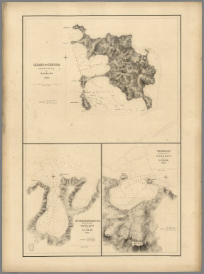
St. Juan Harbour, Straits of Fuca, Vancouver Island by the U.S.Ex.Ex. 1841. Scarborough Harbour, Straits of Fuca, Oregon Territory by the U.S.Ex.Ex. 1841. Port Discovery, Straits of Fuca, Oregon Territory by the U.S.Ex.Ex. 1841.
Publisher
C. Sherman
Author
[Wilkes, Charles, United States Exploring Expedition]
Full Title
Channel of the North Side of Vanua Levu from Muthuata Island to Ivaca Peak, Feejee (Fiji) Islands by the U.S.Ex.Ex. 1840.
Publisher
C. Sherman
Author
[Wilkes, Charles, United States Exploring Expedition]
Full Title
Scabock Harbour, Hoods Canal, Oregon Territory by the U.S.Ex.Ex. 1841. Hooetzen Harbour, Hoods Canal, Oregon Territory by the U.S.Ex.Ex. 1841. Tzu-Sa-Ted Cove, Hoods Canal, Oregon Territory by the U.S.Ex.Ex. 1841.
Publisher
C. Sherman
1-27 of 27
|