Browse All

1846 Cover: Provinces of Canada. Case Map (Covers to) Map Of The Provinces Of Cana … |

1846 Map Of The Provinces Of Canada. Case Map Map Of The Provinces Of Canada, New Brun … |

1845 Broom Road, Tahiti. Exploration Book Broom Road, Tahiti. (Sketched by) A.T. A … |

1845 Tahiti. Exploration Book Island of Tahiti. Engd. by Sherman & Smi … |

1845 Samoan or Navigator Islands. Exploration Book Samoan or Navigator Islands by the U.S. … |

1845 Crater of Kilauea. Exploration Book Crater of Kilauea, Hawaii by the U.S. Ex … |

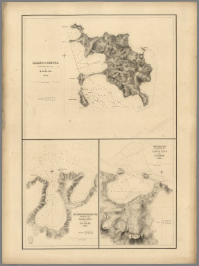
1850 Harbor of Hyannis. Chart Atlas The Harbor of Hyannis. From a trigonomet … |

1847 Holmes' Hole, Tarpaulin Cove. Chart Atlas The harbor of Holmes' Hole ... The harbo … |

1850 New Bedford. Chart Atlas The harbor of New Bedford. Founded upon … |

1846 New Haven Harbor. Chart Atlas New Haven Harbor. Founded upon a trigono … |

1847 Oyster or Syosset Bay. Chart Atlas Oyster or Syosset Bay. Founded upon a tr … |

1850 Cat & Ship Island harbors. Chart Atlas Cat and Ship Island harbors. From a trig … |

1845 Covers: The Western Tourist Or Emigrant' … Guide Book (Covers to) The Western Tourist Or Emigr … |

1845 Title Page: The Western Tourist Or Emigr … Guide Book (Title Page to) The Western Tourist Or E … |

1845 The Western Tourist Or Emigrant's Guide Guide Book Guide Through Ohio, Michigan, Indiana, I … |

1851 Covers: Colton's Western Tourist And Emi … Guide Book (Covers to)The Western Tourist And Emigr … |

1851 Title Page: Western Tourist And Emigrant … Guide Book (Title Page to)The Western Tourist And E … |

1851 Western Tourist And Emigrant's Guide Guide Book Guide through Ohio, Michigan, Indiana, I … |

1839 Covers: The Western Tourist and Emigrant … Guide Book (Covers to) The Western Tourist and Emig … |

1839 Title Page: The Western Tourist and Emig … Guide Book (Title Page to) The Western Tourist and … |

1839 The Western Tourist and Emigrant's Guide Guide Book Guide Through Ohio, Michigan, Indiana, I … |

1855 Covers: Colton's Western Tourist And Emi … Guide Book (Covers to) The Western Tourist And Emig … |

1855 Title Page: The Western Tourist And Emig … Guide Book (Title Page to) The Western Tourist And … |

1855 The Western Tourist And Emigrant's Guide Guide Book Guide Through Ohio, Michigan Indiana, Il … |

1853 Covers: Colton's Western Tourist And Emi … Guide Book (Covers to) The Western Tourist And Emig … |

1853 Title Page: Western Tourist And Emigrant … Guide Book (Title Page to) The Western Tourist And … |

1853 Western Tourist And Emigrant Guide Guide Book Guide Through Ohio, Michigan Indiana, Il … |

1850 Covers: New England, New-York And Canada Pocket Map (Covers to) Sherman & Smith's Railroad, … |

1850 New England, New-York And Canada Pocket Map Sherman & Smith's Railroad, Steam Boat & … |

1847 Covers: Guide for Travelers Through The … Guide Book (Covers to) The Illustrated Hand-Book, A … |

1847 Title Page: Illustrated Hand Book for Tr … Guide Book (Title Page to) The Illustrated Hand-Boo … |

1847 Guide for Travelers Through The United S … Guide Book The Illustrated Hand-Book, A New Guide f … |

1849 Covers: Illustrated Hand-Book, Through T … Guide Book (Covers to) The Illustrated Hand-Book, A … |

1849 Title Page: Illustrated Hand-Book, Throu … Guide Book (Title Page to) The Illustrated Hand-Boo … |

1849 Travellers Guide Through The United Stat … Guide Book A New Map For Travellers Through the Uni … |

1852 Covers: United States Pocket Map (Covers to) A New Map For Travelers Thro … |

1852 United States Pocket Map A New Map For Travelers Through the Unit … |

1853 Covers: New Map For Travelers Through th … Pocket Map (Covers to) A New Map For Travelers Thro … |

1853 A New Map For Travelers Through the Unit … Pocket Map A New Map For Travelers Through the Unit … |

1842 Covers: New-York State Guide Guide Book (Covers to) The New-York State Guide; Co … |

1842 Title Page: New-York State Guide Guide Book (Title Page to) The New-York State Guide … |

1842 New-York State Guide Guide Book The New-York State Guide; Containing An … |

1841 Harbours in Admiralty Inlet, Washington. Chart Map Harbours in Admiralty Inlet, Oregon Terr … |

1840 Admiralty Inlet, Washington. Chart Map Ports Orchard and Madison including the … |

1841 (Nanumanga), Maraki Island, Maiana Islan … Chart Map Hudson's Island (Nanumanga), by the U.S. … |
1840 Island of Yendua, Nucumurry Harbour, Wai … Chart Map Island of Yendua, Feejee (Fiji) Group, b … |

1841 Apia or Charlotte Island, Tarawa or Knox … Chart Map Apia or Charlotte Island, Kingsmill Grou … |

1841 (Hereheretue Atoll), (Nukutepipi), (Anua … Chart Map St. Pablo (Hereheretue Atoll), Paumotu G … |

1841 Disappointment Group, Serle (Pukaruha or … Chart Map Disappointment Group, by the U.S.Ex.Ex. … |

1841 Eastern Group, Sheet 1, Feejee (Fiji) Is … Chart Map Eastern Group, Sheet 1, Feejee (Fiji) Is … |