Who What Where WhenREMOVE |
Author
[Edward Stanford Ltd., Stanford, Edward]
Full Title
New South Wales. London atlas series. Stanford's Geogl. Estabt. London : Edward Stanford, 26 & 27, Cockspur St., Charing Cross, S.W. (1901)
Publisher
Edward Stanford
Author
[Edward Stanford Ltd., Stanford, Edward]
Full Title
Victoria. London atlas series. Stanford's Geographical Establishment. London : Edward Stanford, 26 & 27 Cockspur St., Charing Cross, S.W. (1901)
Publisher
Edward Stanford
Author
[Edward Stanford Ltd., Stanford, Edward]
Full Title
South Australia. London atlas series. Stanford's Geogl. Estabt. London : Edward Stanford, 26 & 27, Cockspur St., Charing Cross, S.W. (1901)
Publisher
Edward Stanford
Author
[Edward Stanford Ltd., Stanford, Edward]
Full Title
Western Australia. London atlas series. Stanford's Geographical Establishment. London : Edward Stanford, 26 & 27, Cockspur St., Charing Cross, S.W. (1901)
Publisher
Edward Stanford
Author
[Edward Stanford Ltd., Stanford, Edward]
Full Title
Tasmania. Fiji Archipelago. London atlas series. Stanford's Geogl. Establishment, London. London : Edward Stanford, 26 & 27, Cockspur St., Charing Cross, S.W. (1901)
Publisher
Edward Stanford
Author
[Edward Stanford Ltd., Stanford, Edward]
Full Title
New Zealand. London atlas series. Stanford's Geographical Estabt. London : Edward Stanford, 12, 13 & 14, Long Acre, W.C. (1901)
Publisher
Edward Stanford
Author
[Edward Stanford Ltd., Stanford, Edward]
Full Title
The Pacific Islands on Mercator's projection. London atlas series. Stanford's Geographical Establishment. London : Edward Stanford, 26 & 27, Cockspur St., Charing Cross, S.W. (1901)
Publisher
Edward Stanford
Author
Stanford, Edward
Full Title
(Covers to) Stanford's London atlas of universal geography exhibiting the physical and political divisions of the various countries of the world. Folio edition. One hundred maps, with a list of latitudes and longitudes. Second issue, revised and enlarged. London, Edward Stanford, Geographer to Her Majesty, 12, 13 & 14 Long Acre, W.C. 1901.
Publisher
Edward Stanford
Author
Stanford, Edward
Full Title
(Half Title Page to) Stanford's London atlas of universal geography exhibiting the physical and political divisions of the various countries of the world. Folio edition. One hundred maps, with a list of latitudes and longitudes. Second issue, revised and enlarged. London, Edward Stanford, Geographer to Her Majesty, 12, 13 & 14 Long Acre, W.C. 1901.
Publisher
Edward Stanford
Author
Stanford, Edward
Full Title
(Title Page to) Stanford's London atlas of universal geography exhibiting the physical and political divisions of the various countries of the world. Folio edition. One hundred maps, with a list of latitudes and longitudes. Second issue, revised and enlarged. London, Edward Stanford, Geographer to Her Majesty, 12, 13 & 14 Long Acre, W.C. 1901.
Publisher
Edward Stanford
Author
Stanford, Edward
Full Title
(Dedication Page to) Stanford's London atlas of universal geography exhibiting the physical and political divisions of the various countries of the world. Folio edition. One hundred maps, with a list of latitudes and longitudes. Second issue, revised and enlarged. London, Edward Stanford, Geographer to Her Majesty, 12, 13 & 14 Long Acre, W.C. 1901.
Publisher
Edward Stanford
Author
Stanford, Edward
Full Title
(Preface to) Stanford's London atlas of universal geography exhibiting the physical and political divisions of the various countries of the world. Folio edition. One hundred maps, with a list of latitudes and longitudes. Second issue, revised and enlarged. London, Edward Stanford, Geographer to Her Majesty, 12, 13 & 14 Long Acre, W.C. 1901.
Publisher
Edward Stanford
Author
Stanford, Edward
Full Title
(Contents to) Stanford's London atlas of universal geography exhibiting the physical and political divisions of the various countries of the world. Folio edition. One hundred maps, with a list of latitudes and longitudes. Second issue, revised and enlarged. London, Edward Stanford, Geographer to Her Majesty, 12, 13 & 14 Long Acre, W.C. 1901.
Publisher
Edward Stanford
Author
Stanford, Edward
Full Title
(Preface to) Stanford's London atlas of universal geography exhibiting the physical and political divisions of the various countries of the world. Folio edition. One hundred maps, with a list of latitudes and longitudes. Second issue, revised and enlarged. London, Edward Stanford, Geographer to Her Majesty, 12, 13 & 14 Long Acre, W.C. 1901.
Publisher
Edward Stanford
Author
Stanford, Edward
Full Title
Colombia, Ecuador and Peru, also Panama. (with Panama Canal Zone). (with) Galapagos Islands, Colon. London: Edward Stanford, Ltd., 12, 13, & 14, Long Acre, W.C. London atlas series. Stanford's Geographical Establishment, London. (1922?)
Publisher
Edward Stanford
Author
Stanford, Edward
Full Title
(Covers to) Colombia, Ecuador and Peru, also Panama. London: Edward Stanford, Ltd., 12, 13, & 14, Long Acre, W.C. London atlas series. Stanford's Geographical Establishment, London. (1922?)
Publisher
Edward Stanford
Author
Stanford, Edward
Full Title
(Inside Covers to) Colombia, Ecuador and Peru, also Panama. London: Edward Stanford, Ltd., 12, 13, & 14, Long Acre, W.C. London atlas series. Stanford's Geographical Establishment, London. (1922?)
Publisher
Edward Stanford
Author
Stanford, Edward
Full Title
Stanford's Map Of The United States And Part Of The Dominion Of Canada. London: Published by Edward Stanford, 55 Charing Cross, September 1st 1875. (inset) Newfoundland, Nova Scotia, Cape Breton & Prince Edward Is.
Publisher
Edward Stanford
Author
Stanford, Edward
Full Title
(Covers to) Stanford's Map Of The United States And Part Of The Dominion Of Canada. London: Published by Edward Stanford, 55 Charing Cross, September 1st 1875. (inset) Newfoundland, Nova Scotia, Cape Breton & Prince Edward Is.
Publisher
Edward Stanford
Author
Stanford, Edward
Full Title
Stanford's Library Map Of North America. Constructed By A. Keith Johnston, F.R.S.E. F.R G.S. &c. London, Edward Stanford, 55 Charing Cross. London, Published July 1st 1863 by Edward Stanford ... Additions to 1875. Engraved by W. & A.K. Johnston, Edinburgh. (inset) Aleutian Islands and Continuation of Aliaska Peninsula.
Publisher
Edward Stanford
Author
Stanford, Edward
Full Title
(Covers to) Stanford's Library Map Of North America. Constructed By A. Keith Johnston, F.R.S.E. F.R G.S. &c. London, Edward Stanford, 55 Charing Cross. London, Published July 1st 1863 by Edward Stanford ... Additions to 1875. Engraved by W. & A.K. Johnston, Edinburgh. (inset) Aleutian Islands and Continuation of Aliaska Peninsula.
Publisher
Edward Stanford
Author
Stanford, Edward
Full Title
Stanford's Library Map Of Asia. New Edition, 1895 ... London: Published by Edward Stanford, 26 & 27, Cockspur St., Charing Cross, S.W,. Decr., 1895. Stanford's Library Series. Stanford's Geographical Establishment.
Publisher
Edward Stanford
Author
Stanford, Edward
Full Title
(Covers to) Stanford's Library Map Of Asia. New Edition, 1895 ... London: Published by Edward Stanford, 26 & 27, Cockspur St., Charing Cross, S.W,. Decr., 1895. Stanford's Library Series. Stanford's Geographical Establishment.
Publisher
Edward Stanford
Author
Stanford, Edward
Full Title
Stanford's Railway & County Map Of The United States And Territories. London. Edward Stanford, 6, Charing Cross. 1861.
Publisher
Edward Stanford
Author
Stanford, Edward
Full Title
(Covers to) Stanford's Railway & County Map Of The United States And Territories. London. Edward Stanford, 6, Charing Cross. 1861.
Publisher
Edward Stanford
Author
Stanford, Edward
Full Title
Stanford's Library Map Of The World On Merctor's Projection. London, Edward Stanford, 26 & 27 Cockspur Street, Charing Cross, S.W. 1900. London: Published by Edward Stanford ... London. Stanford's Geogl. Estabt. (inset) The Arctic Regions. (inset) The Antarctic Regions.
Publisher
Edward Stanford
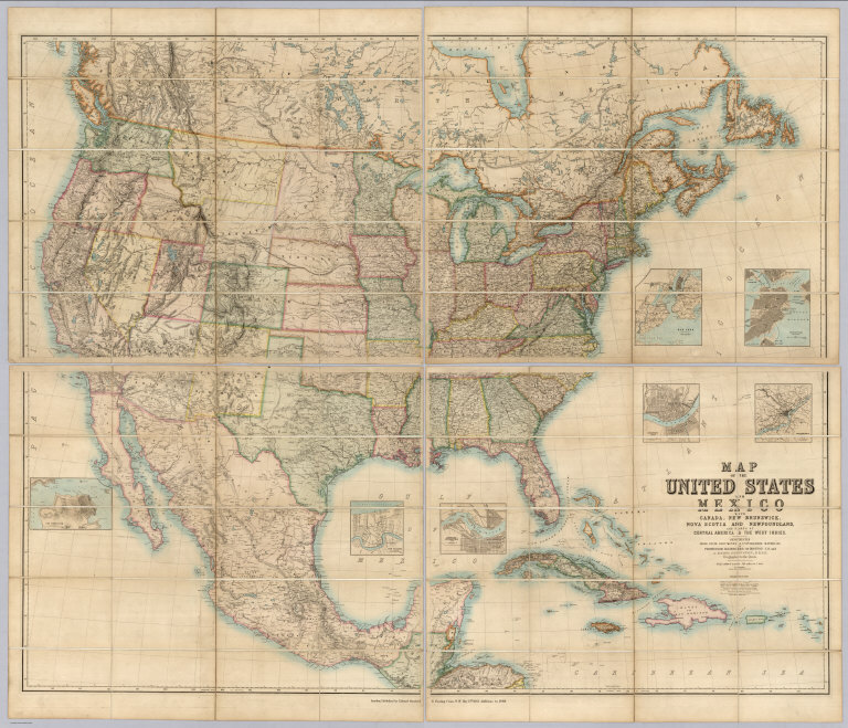
Author
[Johnston, Alexander Keith, 1804-1871, Rogers, Henry Darwin, Stanford, Edward]
Full Title
(Covers to) Map Of The United States And Mexico With Canada, New Brunswick, Nova Scotia and Newfoundland, And Parts Of Central America & The West Indies. Constructed From State Documents & Unpublished Materials By Professor H.D. Rogers of Boston U.S. and A. Keith Johnston, F.R.S.E Geographer to the Queen. London; Published by Edward Stanford, 6 Charing Cross, S.W. May 13th. 1861. Additions to 1869.
Publisher
Edward Stanford
Author
Stanford, Edward
Full Title
Stanford's Map Of India. Based On The Surveys Executed By Order Of The Honourable The East India Company, Special Maps Of The Surveyor General And Other Authorities; Showing The Latest Territorial Acquisitions And The Independent And Protected States, Railways, Canals, &c. 1859. London: Edward Stanford, 6, Charing Cross. Drawn & Engraved by J. & C. Walker. (inset) The Malay Peninsula &c. Showing The British Possessions Beyond The Ganges. (with 3 additional inset maps).
Publisher
Edward Stanford
Author
[Johnston, Alexander Keith, 1804-1871, Rogers, Henry Darwin, Stanford, Edward]
Full Title
(Covers to) Map Of The United States And Mexico With Canada, New Brunswick, Nova Scotia and Newfoundland, And Parts Of Central America & The West Indies. Constructed From State Documents & Unpublished Materials By Professor H.D. Rogers of Boston U.S. and A. Keith Johnston, F.R.S.E Geographer to the Queen. London; Published by Edward Stanford, 6 Charing Cross, S.W. May 13th. 1861. Additions to 1869.
Publisher
Edward Stanford
Author
Stanford, Edward
Full Title
(Covers to) Stanford's Map Of India. Based On The Surveys Executed By Order Of The Honourable The East India Company, Special Maps Of The Surveyor General And Other Authorities; Showing The Latest Territorial Acquisitions And The Independent And Protected States, Railways, Canals, &c. 1859. London: Edward Stanford, 6, Charing Cross. Drawn & Engraved by J. & C. Walker. (inset) The Malay Peninsula &c. Showing The British Possessions Beyond The Ganges. (with 3 additional inset maps).
Publisher
Edward Stanford
|