Who What Where WhenWHAT |
REFINE
Browse All : Atlas Map and National Atlas by Tanner, Henry S.
1-27 of 27
Author
Tanner, Henry S.
Full Title
Part Of Maine &c. with The Boundary Claimed by GRt. Britain. (to accompany) A New Pocket Atlas of the United States With The Roads and Distances, Designed For the Use of Travelers. By H.S. Tanner. Philadelphia: Published by the Author. 1828. (on verso) ...on the seventeenth day of November ... 1828, Henry S. Tanner ... hath deposited ... a book ... Pennsylvania.
Publisher
H.S.Tanner
Author
Tanner, Henry S.
Full Title
New England. (to accompany) A New Pocket Atlas of the United States With The Roads and Distances, Designed For the Use of Travelers. By H.S. Tanner. Philadelphia: Published by the Author. 1828. (on verso) ...on the seventeenth day of November ... 1828, Henry S. Tanner ... hath deposited ... a book ... Pennsylvania.
Publisher
H.S.Tanner
Author
Tanner, Henry S.
Full Title
New York. (to accompany) A New Pocket Atlas of the United States With The Roads and Distances, Designed For the Use of Travelers. By H.S. Tanner. Philadelphia: Published by the Author. 1828. (on verso) ...on the seventeenth day of November ... 1828, Henry S. Tanner ... hath deposited ... a book ... Pennsylvania.
Publisher
H.S.Tanner
Author
Tanner, Henry S.
Full Title
Falls Of Niagara and Adjacent Country. (to accompany) A New Pocket Atlas of the United States With The Roads and Distances, Designed For the Use of Travelers. By H.S. Tanner. Philadelphia: Published by the Author. 1828. (on verso) ...on the seventeenth day of November ... 1828, Henry S. Tanner ... hath deposited ... a book ... Pennsylvania.
Publisher
H.S.Tanner
Author
Tanner, Henry S.
Full Title
Pennsylvania and New Jersey. (to accompany) A New Pocket Atlas of the United States With The Roads and Distances, Designed For the Use of Travelers. By H.S. Tanner. Philadelphia: Published by the Author. 1828. (on verso) ...on the seventeenth day of November ... 1828, Henry S. Tanner ... hath deposited ... a book ... Pennsylvania.
Publisher
H.S.Tanner
Author
Tanner, Henry S.
Full Title
Virginia, Maryland And Delaware. (to accompany) A New Pocket Atlas of the United States With The Roads and Distances, Designed For the Use of Travelers. By H.S. Tanner. Philadelphia: Published by the Author. 1828. (on verso) ...on the seventeenth day of November ... 1828, Henry S. Tanner ... hath deposited ... a book ... Pennsylvania.
Publisher
H.S.Tanner
Author
Tanner, Henry S.
Full Title
Ohio And Indiana. (to accompany) A New Pocket Atlas of the United States With The Roads and Distances, Designed For the Use of Travelers. By H.S. Tanner. Philadelphia: Published by the Author. 1828. (on verso) ...on the seventeenth day of November ... 1828, Henry S. Tanner ... hath deposited ... a book ... Pennsylvania.
Publisher
H.S.Tanner
Author
Tanner, Henry S.
Full Title
Kentucky and Tennessee. (engraved by) J. Knight. Sc. (to accompany) A New Pocket Atlas of the United States With The Roads and Distances, Designed For the Use of Travelers. By H.S. Tanner. Philadelphia: Published by the Author. 1828. (on verso) ...on the seventeenth day of November ... 1828, Henry S. Tanner ... hath deposited ... a book ... Pennsylvania.
Publisher
H.S.Tanner
Author
Tanner, Henry S.
Full Title
North & South Carolina. (engraved by) J. Knight. Sc. (to accompany) A New Pocket Atlas of the United States With The Roads and Distances, Designed For the Use of Travelers. By H.S. Tanner. Philadelphia: Published by the Author. 1828. (on verso) ...on the seventeenth day of November ... 1828, Henry S. Tanner ... hath deposited ... a book ... Pennsylvania.
Publisher
H.S.Tanner
Author
Tanner, Henry S.
Full Title
Georgia and Alabama. (engraved by) J. Knight. Sc. (to accompany) A New Pocket Atlas of the United States With The Roads and Distances, Designed For the Use of Travelers. By H.S. Tanner. Philadelphia: Published by the Author. 1828. (on verso) ...on the seventeenth day of November ... 1828, Henry S. Tanner ... hath deposited ... a book ... Pennsylvania.
Publisher
H.S.Tanner
Author
Tanner, Henry S.
Full Title
Louisiana And Mississippi. (engraved by) J. Knight. Sc. (to accompany) A New Pocket Atlas of the United States With The Roads and Distances, Designed For the Use of Travelers. By H.S. Tanner. Philadelphia: Published by the Author. 1828. (on verso) ...on the seventeenth day of November ... 1828, Henry S. Tanner ... hath deposited ... a book ... Pennsylvania.
Publisher
H.S.Tanner
Author
Tanner, Henry S.
Full Title
Illinois And Missouri. (engraved by) J. Knight. Sc. (inset) Missouri River, West Part. (to accompany) A New Pocket Atlas of the United States With The Roads and Distances, Designed For the Use of Travelers. By H.S. Tanner. Philadelphia: Published by the Author. 1828. (on verso) ...on the seventeenth day of November ... 1828, Henry S. Tanner ... hath deposited ... a book ... Pennsylvania.
Publisher
H.S.Tanner
Author
Melish, John
Full Title
Map of the American Coast, from Lynhaven Bay to Narraganset Bay, by John Melish.
Publisher
John Melish
Author
Melish, John
Full Title
Map of the Seat of War in North America. J. Melish del. H.S. Tanner, Dirext. Entered as the Art Directs, and Published by John Melish, Philadelphia.
Publisher
John Melish
Author
Melish, John
Full Title
East End of Lake Ontario.
Publisher
John Melish
Author
Melish, John
Full Title
Plan of Montreal, with a Map of the Islands & adjoining Country.
Publisher
John Melish
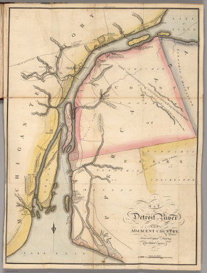
Author
Melish, John
Full Title
Map of Detroit River and Adjacent Country, From an Original Drawing, by a British Engineer.
Publisher
John Melish
Author
Melish, John
Full Title
Plan of Quebec and Adjacent Country Shewing The principal Encampments & Works of the British & French Armies during the Siege by General Wolfe in 1759. Reduced from the M.S.S. Map of Capt. J.B. Glegg, by John Melish.
Publisher
John Melish
Author
Melish, John
Full Title
Map of the Seat of War in North America. J. Melish del. H.S. Tanner, Dirext. Entered as the Art Directs, and Published by John Melish, Philadelphia.
Publisher
John Melish
Author
Melish, John
Full Title
East End of Lake Ontario.
Publisher
John Melish
Author
Melish, John
Full Title
Plan of Montreal, with a Map of the Islands & adjoining Country.
Publisher
John Melish
Author
Melish, John
Full Title
Map of the American Coast, from Lynhaven Bay to Narraganset Bay, by John Melish.
Publisher
John Melish
Author
Melish, John
Full Title
Map of Detroit River and Adjacent Country, From an Original Drawing, by a British Engineer.
Publisher
John Melish
Author
Melish, John
Full Title
Plan of Quebec and Adjacent Country Shewing The principal Encampments & Works of the British & French Armies during the Siege by General Wolfe in 1759. Reduced from the M.S.S. Map of Capt. J.B. Glegg, by John Melish.
Publisher
John Melish
Author
Melish, John
Full Title
East End of Lake Ontario and River St. Lawrence From Kingston to French Mills Reduced from an Original Drawing in the Naval Department by John Melish.
Publisher
John Melish
Author
Melish, John
Full Title
Map of the River St. Lawrence and Adjacent Country From Williamsburg to Montreal from and Original Drawing in the War Department.
Publisher
John Melish
1-27 of 27
|