Browse All

1832 Introduction: Atlas of Scotland. National Atlas (Introduction to) The atlas of Scotland, … |

1832 Index 1: Edinburghshire. National Atlas (Index Page to) The atlas of Scotland, c … |

1832 Index 2-3: Haddington, Berwick Shires. National Atlas (Index Page to) The atlas of Scotland, c … |

1832 Index 4-6: Roxburgh, Selkirk, Dumfries S … National Atlas (Index Page to) The atlas of Scotland, c … |

1832 Index 7-8: Kirkcudbright, Wigton Shirer. National Atlas (Index Page to) The atlas of Scotland, c … |

1832 Index 9-10: Ayr, Peebles Shires. National Atlas (Index Page to) The atlas of Scotland, c … |

1832 Index 11: Lanarkshire. National Atlas (Index Page to) The atlas of Scotland, c … |

1832 Index 12-14: Renfrew, Linlithgow, Stirli … National Atlas (Index Page to) The atlas of Scotland, c … |

1832 Index 14-16: Stirling, Dumbarton, Bute S … National Atlas (Index Page to) The atlas of Scotland, c … |

1832 Index 17-18: Argyle, Perth, Clackmannan … National Atlas (Index Page to) The atlas of Scotland, c … |

1832 Index 24-25: Western Islands, Ross, Crom … National Atlas (Index Page to) The atlas of Scotland, c … |

1832 Index 26-28: Sutherland, Caithness Shire … National Atlas (Index Page to) The atlas of Scotland, c … |

1832 Index 28-29: Orkney, Shetland Islands. National Atlas (Index Page to) The atlas of Scotland, c … |

1832 Composite: Ayrshire National Atlas (Composite of) Ayrshire. Compiled from e … |

1817 Cover: New general atlas World Atlas (Covers to) A new general atlas, consist … |

1817 Title Page: New general atlas World Atlas (Title Page to) A new general atlas, con … |

1817 Contents: New general atlas World Atlas (Contents to) A new general atlas, consi … |

1817 Contents: New general atlas World Atlas (Contents to) A new general atlas, consi … |
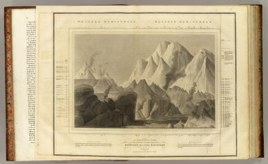
1817 Heights of mountains. World Atlas A comparative view of the heights of the … |

1814 Hydrographical chart of the World. World Atlas Hydrographical chart of the World on Wri … |

1814 N. Hemisphere. World Atlas Northern Hemisphere. Kirkwood sculp. Dra … |

1814 S. Hemisphere. World Atlas Southern Hemisphere. Kirkwood sculp. Dra … |

1815 E. Hemisphere. World Atlas Eastern Hemisphere. Drawn & engraved for … |

1815 W. Hemisphere. World Atlas Western Hemisphere. Drawn & engraved for … |

1816 N. Hemisphere, plane of London. World Atlas Northern Hemisphere projected on the pla … |

1816 S. Hemisphere, plane of London. World Atlas Southern Hemisphere projected on the pla … |

1817 Europe. World Atlas Europe. J. & G. Menzies sculpt. (1817) |

1815 British Isles. World Atlas British Isles. Drawn & engraved by Hewit … |

1815 Ireland. World Atlas Ireland. Neale (i.e. Neele) sculpt., Str … |

1815 Scotland. World Atlas Scotland. Drawn & engraved by Hewitt, Br … |

1814 England. World Atlas England. Neele sculpt., Strand, London. … |

1817 Remote British islands. World Atlas Remote British islands. Drawn & engraved … |

1814 British Channel. World Atlas The British Channel. J. & G. Menzies scu … |

1816 North, Baltic seas. World Atlas Chart of the North and Baltic seas, &c. … |

1817 Scandinavia. World Atlas Scandinavia, or Sweden, Denmark & Norway … |

1814 Denmark, Iceland, Feroe Islands. World Atlas Denmark. (with) Iceland. (with) Feroe Is … |

1816 Germany N. of Mayne. World Atlas Germany north of the Mayne. Neele sc., S … |

1814 Holland. World Atlas Holland. Neele sculpt., London. Drawn & … |

1815 Belgium. World Atlas Belgium or the Netherlands. Drawn and en … |

1817 France. World Atlas France. Engd. by Kirkwood & Son, Edinr. … |

1814 France, provinces. World Atlas France, in provinces. Kirkwood sculpt. D … |

1815 Spain, Portugal. World Atlas Spain & Portugal. J. & G. Menzies sculpt … |

1817 Mediterranean Sea. World Atlas Chart of the Mediterranean Sea. (with) B … |

1815 Attica, Turkey in Europe. World Atlas Attica. Turkish dominions in Europe. E. … |

1814 Italy. World Atlas Italy. (with) Island of Elba. R. Scott, … |

1816 Venetian States. World Atlas Venetian States. Drawn & engraved by N.R … |

1814 Swisserland, Mt. Blanc. World Atlas Swisserland (with view) Mont Blanc, near … |

1816 Germany S. of Mayne. World Atlas Germany south of the Mayne. Neele sc., L … |

1816 Austrian Dominions. World Atlas Austrian Dominions. Neele, sculp., 352, … |

1817 Prussian Dominions. World Atlas Prussian Dominions. Engd. by W. Dassauvi … |