|
REFINE
Browse All : Images by U.S. Coast and Geodetic Survey of Alaska
1-13 of 13
Author
[U.S. General Land Office, King, Harry, Hendges, M.]
Full Title
Map of Alaska. Compiled from the official records of the General Land Office, U.S. Coast & Geodetic Survey, U.S. Geological Survey, Canadian and other sources, under the direction of Harry King, C. E., Chief of Drafting Division G.L.O. 1898. (at head of title) Department of the Interior General Land Office Hon. Binger Hermann, Commissioner. Compiled and drawn by M. Hendges. The Friedennwald Co. Photo. Lith. Balto. (Insets) From Juneau to Forty Mile Creek, and Aleutian Islands.
Publisher
Dept. of the Interior, General Land Office
Author
United States. Alaska Road Commission
Full Title
Map of Alaska By the Alaska Road Commission. 1909. (Upper left sheet) Compiled from Surveys of the Alaska Road Commission, the U.S. Coast and Geodetic Survey, U.S. Geological Survey, U.S. Army Surveys, and the Canadian Geological Survey. Drawn by Jas. H. Watson. C.E. Superintendent A.R.C. Andrew B. Graham Co., lithographers, Washington, D.C. (insets) Aleutian Islands ; (St. Lawrence, Nunivak Island, and Pribilof Islands.)
Publisher
Alaska Road Commission ; Andrew B. Graham Co.
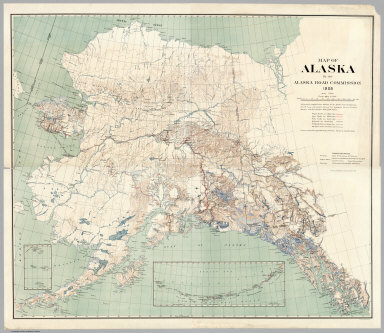
Author
United States. Alaska Road Commission
Full Title
Map of Alaska By the Alaska Road Commission. 1909. (Upper right sheet) Compiled from Surveys of the Alaska Road Commission, the U.S. Coast and Geodetic Survey, U.S. Geological Survey, U.S. Army Surveys, and the Canadian Geological Survey. Drawn by Jas. H. Watson. C.E. Superintendent A.R.C. Andrew B. Graham Co., lithographers, Washington, D.C. (insets) Aleutian Islands ; (St. Lawrence, Nunivak Island, and Pribilof Islands.)
Publisher
Alaska Road Commission ; Andrew B. Graham Co.
Author
United States. Alaska Road Commission
Full Title
Map of Alaska By the Alaska Road Commission. 1909. (Lower left sheet) Compiled from Surveys of the Alaska Road Commission, the U.S. Coast and Geodetic Survey, U.S. Geological Survey, U.S. Army Surveys, and the Canadian Geological Survey. Drawn by Jas. H. Watson. C.E. Superintendent A.R.C. Andrew B. Graham Co., lithographers, Washington, D.C. (insets) Aleutian Islands ; (St. Lawrence, Nunivak Island, and Pribilof Islands.)
Publisher
Alaska Road Commission ; Andrew B. Graham Co.
Author
United States. Alaska Road Commission
Full Title
Map of Alaska By the Alaska Road Commission. 1909. (Lower right sheet) Compiled from Surveys of the Alaska Road Commission, the U.S. Coast and Geodetic Survey, U.S. Geological Survey, U.S. Army Surveys, and the Canadian Geological Survey. Drawn by Jas. H. Watson. C.E. Superintendent A.R.C. Andrew B. Graham Co., lithographers, Washington, D.C. (insets) Aleutian Islands ; (St. Lawrence, Nunivak Island, and Pribilof Islands.)
Publisher
Alaska Road Commission ; Andrew B. Graham Co.
Author
United States. Alaska Road Commission
Full Title
(Composite Map to) Map of Alaska By the Alaska Road Commission. 1909. Compiled from Surveys of the Alaska Road Commission, the U.S. Coast and Geodetic Survey, U.S. Geological Survey, U.S. Army Surveys, and the Canadian Geological Survey. Drawn by Jas. H. Watson. C.E. Superintendent A.R.C. Andrew B. Graham Co., lithographers, Washington, D.C. (insets) Aleutian Islands ; (St. Lawrence, Nunivak Island, and Pribilof Islands.)
Publisher
Alaska Road Commission ; Andrew B. Graham Co.
Author
[U.S. Coast and Geodetic Survey, Alaskan Boundary Tribunal, Nichols, H.E.]
Full Title
(Facsimile) No. 10. Tracing by the Coast Survey, showing the features of the region on the north shore of Portland Inlet near its mouth. U.S. Coast and Geodetic Survey. F.M. Thorn, Superintendent. Portland Inlet, Alaska. Surveyed by Lieut. Comdr. H.E. Nichols, U.S.N. in 1882. (Reduced from original scale). Photo. Lith. by A. Hoen & Co. Baltimore, MD.
Publisher
(U.S.) Government Printing Office
Author
[U.S. Coast and Geodetic Survey, Alaskan Boundary Tribunal, Nichols, H.E.]
Full Title
(Facsimile) U.S. Coast and Geodetic Survey, F.M. Thorn, Superintendent. N.W. Shore of Portland Inlet, Alaska. Surveyed by Lt. Comd. H.E. Nichols, U.S.N. Assistant. 1888. Photo. Lith. by A. Hoen & Co. Baltimore, MD. No. 10 - Tracing by the Coast Survey, showing the features of the region on the north shore of Portland Inlet near its mouth. (Reduced from original scale).
Publisher
(U.S.) Government Printing Office
Author
[U.S. Coast and Geodetic Survey, Alaskan Boundary Tribunal]
Full Title
(Facsimile) General Map Adjacent Parts of North America and Asia. Prepared at the Office of the Coast and Geodetic Survey. Alaskan Boundary Tribunal, 1903. No. 1. Photo. Lith. by A. Hoen & Co. Baltimore, MD.
Publisher
Government Printing Office
Author
[U.S. Coast and Geodetic Survey, Alaskan Boundary Tribunal]
Full Title
(Facsimile) Map of Southeastern Alaska. Prepared at the Office of the U.S. Coast and Geodetic Survey from the Latest Official U.S. and Canadian Surveys. Alaskan Boundary Tribunal, 1903. 2. Photo. Lith. by A. Hoen & Co. Baltimore, MD.
Publisher
Government Printing Office
Author
[U.S. Coast and Geodetic Survey, Alaskan Boundary Tribunal]
Full Title
(Facsimile) Map of Southeastern Alaska. Showing the Four Boundary Lines proposed by Sir Charles Bagot during the British-Russian Negotiations. Prepared at the Office of the U.S. Coast and Geodetic Survey from the Latest Official U.S. and Canadian Surveys. Alaskan Boundary Tribunal, 1903. 3. Photo. Lith. by A. Hoen & Co. Baltimore, MD.
Publisher
Government Printing Office
Author
[U.S. Coast and Geodetic Survey, Alaskan Boundary Tribunal, Emmons, G.T.]
Full Title
(Facsimile) Map of Southeastern Alaska. Showing locations of the principal Indian villages, as fixed by Lieut. G.T. Emmons, U.S.N. Prepared at the Office of the U.S. Coast and Geodetic Survey from the Latest Official U.S. and Canadian Surveys. Alaskan Boundary Tribunal, 1903. 25. Photo. Lith. by A. Hoen & Co. Baltimore, MD.
Publisher
Government Printing Office
Author
[U.S. Coast and Geodetic Survey, Alaskan Boundary Tribunal]
Full Title
(Facsimile) Map of Southeastern Alaska. Prepared at the Office of the U.S. Coast and Geodetic Survey from the Latest Official U.S. and Canadian Surveys. Showing also in red the boundary now claimed by Great Britain (See Case of Great Britain, Appendix, Vol. II, Map 37) and by tints the division between the drainage systems of the pacific slope of the interior rivers. Alaskan Boundary Tribunal, 1903. 26. Andrew B Graham. Photo-Litho. Washington.D.C.
Publisher
Government Printing Office
1-13 of 13
|