Browse All

1937 Southwestern National Monuments. Separate Map Southwestern National Monuments. Headqua … |

1876 View: Trap Dyke, Pope's Well, S. of Sant … Exploration Book (View) Trap Dyke, Pope's Well, S. of San … |

1876 View: Plate I. Abiquiu Peak, Looking Wes … Exploration Book (View) Plate I. Abiquiu Peak, Looking We … |

1876 View: Plate II. Near Vado Del Chama, Upp … Exploration Book (View) Plate II. Near Vado Del Chama, Up … |

1876 View: The Pagosa, S.W. Colorado, San Jua … Exploration Book (View) The Pagosa, S.W. Colorado, San Ju … |

1876 View: Plate IV. The Pagosa & San Juan Ri … Exploration Book (View) Plate IV. The Pagosa & San Juan R … |

1876 View: Plate III. La Piedra Parada, Looki … Exploration Book (View) Plate III. La Piedra Parada, Look … |

1876 View: Plate V. Rio Dolores & Sierra de l … Exploration Book (View) Plate V. Rio Dolores & Sierra de … |

1876 View: Plate VI. Casa Colorado & La Sal-M … Exploration Book (View) Plate VI. Casa Colorado & La Sal- … |

1876 View: Ruins of Stone Houses Cliffs, Laby … Exploration Book (View) Ruins of Stone Houses Cliffs, Lab … |

1876 View: Plate VII. Head of Labyrinth Creek … Exploration Book (View) Plate VII. Head of Labyrinth Cree … |

1876 View: Plate VIII. Head of Canon (Canyon) … Exploration Book (View) Plate VIII. Head of Canon (Canyon … |

1876 View: Plate IX. Lower San Juan, Looking … Exploration Book (View) Plate IX. Lower San Juan, Looking … |
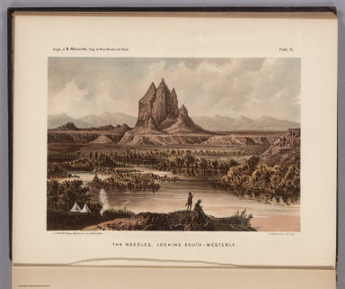
1876 View: Plate X. The Needles, Looking Sout … Exploration Book (View) Plate X. The Needles, Looking Sou … |

1876 View: Plate XI. The Cabazon from near Ca … Exploration Book (View) Plate XI. The Cabazon from near C … |

1876 Text and View: Plate I. Cretaceous Fossi … Exploration Book (Text and View) Plate I. Cretaceous Foss … |

1876 Text and View: Plate II. Cretaceous Foss … Exploration Book (Text and View) Plate II. Cretaceous Fos … |

1876 Text and View: Plate III. Carboniferous … Exploration Book (Text and View) Plate III. Carboniferous … |

1876 Text and View: Plate IV. (Carboniferous … Exploration Book (Text and View) Plate IV. (Carboniferous … |

1876 Text and View: Plate V. (Carboniferous & … Exploration Book (Text and View) Plate V. (Carboniferous … |

1876 Text and View: Plate VI. (Carboniferous … Exploration Book (Text and View) Plate VI. (Carboniferous … |

1876 Text and View: Plate VII. (Carboniferous … Exploration Book (Text and View) Plate VII. (Carboniferou … |

1876 Text and View: Plate VIII. (Carboniferou … Exploration Book (Text and View) Plate VIII. (Carbonifero … |

1895 Title Page: Atlas official records Union … Military Atlas (Title Page to) Atlas to accompany the o … |

1895 Preface. Military Atlas (Text Page to) Atlas to accompany the of … |

1895 Contents: Atlas official records Union a … Military Atlas (Contents to) Atlas to accompany the off … |

1895 Contents: Atlas official records Union a … Military Atlas (Contents to) Atlas to accompany the off … |

1895 Ft. Moultrie, Ft. Johnson, Morris I., Cu … Military Atlas Fort Moultrie as seen from Fort Sumter, … |

1895 Cumming's Pt. batteries, works. Military Atlas Appearance of the batteries on Cumming's … |

1895 Bull Run, Manassas. Military Atlas Plan of the battle-field at Bull Run, Ju … |

1895 Charleston defenses, Belmont battlefield … Military Atlas Map of the defenses of Charleston City a … |

1895 Youngs Branch; Columbus, Ky. Military Atlas Battle-field of Youngs Branch or Manassa … |

1895 Defenses Washington. Military Atlas Defenses of Washington. Map of the groun … |

1895 N.E. Virginia, Washington 1. Military Atlas Surveys for military defenses. Map of no … |
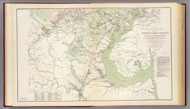
1895 N.E. Virginia, Washington 2. Military Atlas Surveys for military defenses. Map of no … |

1895 Valverde, Shiloh, Ft. Craig, Roanoke Isl … Military Atlas Engagement at Valverde, N.M., February 2 … |

1895 Monterey, Tenn.-Corinth, Miss. Military Atlas Map of the country between Monterey, Ten … |

1895 Siege of Yorktown. Military Atlas Reconnaissance of secession works and pl … |

1895 Yorktown, Gloucester, Va. Military Atlas Reconnaissance of the secession works at … |

1895 SE Virginia, Ft. Monroe. Military Atlas Part of the map of the Military Departme … |

1895 SE Virginia, Ft. Monroe, approaches to R … Military Atlas Part of the map of the Military Departme … |

1895 Dept. of Virginia, Yorktown to Williamsb … Military Atlas Copy of a map. Sheet no. 1 military reco … |

1895 White House-Harrison's Landing. Military Atlas Campaign maps, Army of the Potomac. Map … |

1895 Battle-grounds Richmond, Va. Military Atlas Map of the Battle-grounds in the vicinit … |

1895 Hanover, Hanover C.H., New Bridge, Mecha … Military Atlas Rough sketch of reconnaissance, May 24th … |

1895 Cav. Brigade, Cedar Mtn., Manassas, Bull … Military Atlas Map of the operations of the Cavalry Bri … |

1895 1st Corps Army of Virginia; Secessionvil … Military Atlas Map of route and positions, First Corps, … |

1895 Army of the Cumberland. Military Atlas Section of map prepared to exhibit the c … |

1895 Battle of Corinth; Iuka; Bayou Fourche; … Military Atlas Plan of the battle of Corinth fought on … |

1895 Suffolk & vicinity. Military Atlas Military map of Suffolk and vicinity for … |