Who What Where WhenWHEREShow More |
REFINE
Browse All : Images by U.S. War Department, Topographical Engineers of Maryland
1-4 of 4
Author
U.S. War Department, Topographical Engineers
Full Title
Part of Washington County, MD. Bureau of Topographical Engineers September, 1862.
Publisher
Bureau of Topographical Engineers
Author
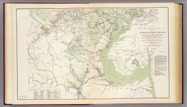
[Hesselbach, W., U.S. War Department, Topographical Engineers, United States. War Department, Young, J. J.]
Full Title
Surveys for military defenses. Map of northeastern Virginia and vicinity of Washington. Sheet 1. Compiled in Topographical Engineers Office at division headquarters of General Irvin McDowell, Arlington, January 1, 1862. Corrected from recent surveys and reconnaissances under direction of the Bureau of Topographical Engineers, August 1, 1862. Drawn by J.J. Young and W. Hesselbach. Julius Bien & Co., Lith., N.Y. (1891-1895)
Publisher
U.S. Government Printing Office
Author
[Hesselbach, W., U.S. War Department, Topographical Engineers, United States. War Department, Young, J. J.]
Full Title
Surveys for military defenses. Map of northeastern Virginia and vicinity of Washington. Sheet 2. Compiled in Topographical Engineers Office at division headquarters of General Irvin McDowell, Arlington, January 1, 1862. Corrected from recent surveys and reconnaissances under direction of the Bureau of Topographical Engineers, August 1, 1862. Drawn by J.J. Young and W. Hesselbach. Julius Bien & Co., Lith., N.Y. (1891-1895)
Publisher
U.S. Government Printing Office
Author
U.S. War Department, Topographical Engineers
Full Title
Part of map of portions of the military departments of Washington, Pennsylvania, Annapolis and Northeastern Virginia. Compiled in the Bureau of Topographical Engrs., War Department &c., July 1861 ... report of Maj. Gen. Geo. B. McClellan ... and Maj. A.J. Myer ... Battle-fields of South Mountain showing the positions of the forces of the United States and of the enemy during the battle fought by the Army of the Potomac under the command of Maj. Gen. Geo. B. McClellan, Sept. 14, 1862. Prepared in the Bureau of Topographical Engineers. (with) Map accompanying Lieutenant General Pemberton's report of operations near Vicksburg, Miss., December 21, 1862, January 2, 1863. Surveyed and drawn by H.A. Pattison, Civil Engr. Julius Bien & Co., Lith., N.Y. (1891-1895)
Publisher
U.S. Government Printing Office
1-4 of 4
|