Browse All

1877 Winnemucca, Ft. Fred Steele, Laramie, Gr … Exploration Book Sketch of Winnemucca, Nevada showing pos … |

1877 Pioche, Virginia City, Hughes, Colorado … Exploration Book Sketch of Pioche, Nevada showing positio … |

1877 Beaver, Cheyenne, Fort Union, Georgetown … Exploration Book Sketch of Beaver, Utah showing position … |

1877 Diurnal barometric curves. Exploration Book Diurnal barometric curves. Horary curves … |

1877 Diurnal barometric curves. Exploration Book Diurnal barometric curves. Horary curves … |

1877 Diurnal barometric curves. Exploration Book Diurnal barometric curves. Trinidad, Col … |

1877 Diurnal barometric curves. Exploration Book Diurnal barometric curves. Prescott, Ari … |

1877 Diurnal temperature. Exploration Book Diurnal temperature. Georgetown, Col. Sa … |

1877 Diurnal temperature. Exploration Book Diurnal temperature. Beaver, Utah. Camp … |

1877 Diurnal temperature. Exploration Book Diurnal temperature. Trinidad, Col. Pres … |

1877 Differences, wet, dry bulb thermometers. Exploration Book Mean differences, wet and dry bulb therm … |

1877 Differences, wet, dry bulb thermometers. Exploration Book Mean differences, wet and dry bulb therm … |

1877 Differences, wet, dry bulb thermometers. Exploration Book Mean differences, wet and dry bulb therm … |

1877 Diurnal force of vapor. Exploration Book Diurnal force of vapor. Colorado Springs … |

1877 Diurnal force of vapor. Exploration Book Diurnal force of vapor. Beaver, Utah. Co … |

1880 1880. Progress Map Of The U.S. Geographi … National Atlas 1880. Progress Map Of The U.S. Geographi … |

1882 1882. Progress Map Of The U.S. Geographi … National Atlas 1882. Progress Map Of The U.S. Geographi … |

1873 Map Of The Areas Of Drainage To The Atla … National Atlas Map Of The Areas Of Drainage To The Atla … |

1881 32C. Land Classification Map Of Part Of … National Atlas Land Classification Map Of Part Of South … |

1874 Mean temperature US. Statistical Atlas U.S. Signal Service chart showing the me … |

1874 Barometer, air movement US. Statistical Atlas U.S. Signal Service chart, showing annua … |

1874 Hypsometric sketch US. Statistical Atlas Hypsometric sketch of the United States. … |

1874 Coal fields US. Statistical Atlas Map of the coal fields of the United Sta … |

1874 Geological map US. Statistical Atlas Geological map of the United States comp … |

1874 Acquisition of territory US. Statistical Atlas Map showing the acquisition of territory … |

1874 US Population 1790-1820. Statistical Atlas The progress of the nation, 1790-1820. M … |

1874 US Population 1830, 1840. Statistical Atlas Map showing, in five degrees of density, … |

1874 US Population 1850. Statistical Atlas Map showing in five degrees of density, … |

1874 US Population 1860. Statistical Atlas Map showing in five degrees of density, … |

1874 US Population 1870. Statistical Atlas Map showing, in five degrees of density, … |

1874 Population by state. Statistical Atlas Chart showing the principal constitution … |

1874 Colored population density 1870. Statistical Atlas Map showing in five degrees of density t … |

1874 Colored population proportion 1870. Statistical Atlas Map showing the proportion of the colore … |

1874 Foreign parentage 1870. Statistical Atlas Map showing, in five degrees of density, … |

1874 Foreign parentage proportion 1870. Statistical Atlas Map showing the proportion to the aggreg … |

1874 Foreign population 1870. Statistical Atlas Map showing five degrees of density the … |

1874 Foreign population proportion 1870. Statistical Atlas Map showing the proportion of the foreig … |

1874 Irish, German population 1870. Statistical Atlas Maps showing the distribution, within th … |

1874 British American, English, Welsh, Swedis … Statistical Atlas (Maps showing the distribution, within t … |

1874 Illiteracy 1870. Statistical Atlas Map showing the illiteracy of the aggreg … |

1874 White male illiteracy. Statistical Atlas Map showing the illiteracy of the adult … |
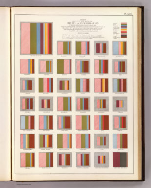
1874 Church accommodation. Statistical Atlas Chart showing the ratio of Church accomm … |
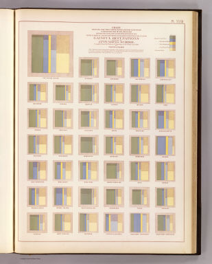
1874 Occupations, school attendance. Statistical Atlas Chart showing for the United States and … |

1874 Wealth distribution US. Statistical Atlas Map showing the distribution of wealth. … |

1874 Public indebtedness US. Statistical Atlas Map showing the degree of public indebte … |

1874 Taxation per capita US. Statistical Atlas Map showing the degree of taxation per c … |

1874 Fiscal chart US. Statistical Atlas Fiscal chart of the United States showin … |

1874 Crops US. Statistical Atlas Maps showing the range, and within the r … |

1874 Farms, production, corn, dairy. Statistical Atlas Improved land in farms. Total agricultur … |

1874 Pacific Coast subjects. Statistical Atlas Maps of the Pacific Coast exhibiting var … |