Browse All

1816 Map of the United States with the contig … Case Map Map of the United States with the contig … |

1823 Composite: United States with the contig … Case Map (Composite of) Map of the United States … |

1816 Composite: Map of the United States with … Case Map Map of the United States with the contig … |

1815 Covers: An Atlas Of Ten Select Maps Of A … Classical Atlas (Covers to) An Atlas Of Ten Select Maps … |

1815 Title Page: An Atlas Of Ten Select Maps … Classical Atlas (Title Page to) An Atlas Of Ten Select M … |

1815 Contents: An Atlas Of Ten Select Maps Of … Classical Atlas (Contents to) An Atlas Of Ten Select Map … |

1815 Terra Veteribus Nota Classical Atlas Terra Veteribus Nota. Engraved for Mayo' … |

1815 Romanum Imperium Classical Atlas Romanum Imperium. Engraved for Mayo's An … |

1815 Orientis Tabula Classical Atlas Orientis Tabula. Engraved for Mayo's Anc … |

1815 Graecia Antiqua Classical Atlas Graecia Antiqua. Engraved for Mayo's Anc … |

1815 Italia Antiqua Classical Atlas Italia Antiqua. Engraved for Mayo's Anci … |

1815 The Places Recorded in the Five Books of … Classical Atlas The Places Recorded in the Five Books of … |

1815 The Land of Moriah or Jerusalem and the … Classical Atlas The Land of Moriah or Jerusalem and the … |

1815 State of Nations at the Christian aera F … Classical Atlas State of Nations at the Christian aera F … |
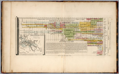
1815 An Historical Chart representing ... of … Classical Atlas An Historical chart representing in a ch … |

1811 A Map Of The State Of Pennsylvania. Pocket Map A Map Of The State Of Pennsylvania By Re … |

1811 Cover: Pennsylvania. Pocket Map (Covers to) A Map Of The State Of Pennsy … |

1813 View of the Country round the Falls of N … National Atlas View of the Country round the Falls of N … |

1823 (NW Part only) United States with the co … Case Map (Northwestern Part only of) Map of the U … |

1820 Europe. School Atlas Europe. No. V. Published 1st June 1816 b … |

1820 Africa. School Atlas Africa. No. VI. (Published 1st June 1816 … |

1795 State of North Carolina. National Atlas The State of North Carolina from the bes … |

1831 Orientis Tabula. [Classical Atlas, World Atlas] Orientis Tabula. J. Vallance fc. Publish … |

1831 Historical Chart ... of the prinicipal E … [Classical Atlas, World Atlas] An Historical Chart representing in a Ch … |

1815 View of the Country round the Falls of N … National Atlas View of the Country round the Falls of N … |

1812 View of the Country round Pittsburg. Exploration Book View of the Country round Pittsburg. Dra … |

1812 Kentucky. Exploration Book Kentucky. Drawn by J. Melish. J. Vallanc … |

1812 Ohio. Exploration Book Ohio. Drawn by J. Melish. J. Vallance sc … |

1812 View of the Country round Zanesville. Exploration Book View of the Country round Zanesville. Dr … |

1812 View of the Country round the Falls of N … Exploration Book View of the Country round the Falls of N … |

1823 United States with the contiguous Britis … Case Map Map of the United States with the contig … |