Who What Where WhenREMOVE |
REFINE
Browse All : Images by Velhagen & Klasing of Ireland
1-3 of 3
Full Title
Grossbritannien und Irland. (with) Die Canal Inseln. (with) Die Shetland Inseln. (Richard Andree. Herausgegeben von der Geographischen Anstalt von Velhagen & Klasing in Leipzig. 1881)
Publisher
Velhagen & Klasing
Author
[Andree, Richard, Scobel, Albert]
Full Title
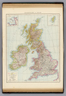
Ubersichtskarte von Groszbritannien und Irland. Mai.1905. Bearb. v. G. Jungk. Lithogr. v. P. Franke, H. Anschutz u. A.Soeder. Flachentreue Azmut-Projektion. (insets : nebenkarten) Shetland und Orkney-Inseln ; Umgebung von London ; Britische Kolonien.
Publisher
Velhagen & Klasing
1-3 of 3
|