|
Author
[United States. Census Office, Walker, Francis Amasa, 1840-1897]
Full Title
(Covers to) Statistical atlas of the United States based on the results of the ninth census 1870 with contributions from many eminent men of science and several departments of the government. Compiled under authority of Congress by Francis A. Walker, M.A., Superintendent of the 9th Census, professor of political economy and history, Sheffield Scientific School of Yale College. Julius Bien, Lith., 1874.
Publisher
U.S.
Author
[United States. Census Office, Walker, Francis Amasa, 1840-1897]
Full Title
(Title Page to) Statistical atlas of the United States based on the results of the ninth census 1870 with contributions from many eminent men of science and several departments of the government. Compiled under authority of Congress by Francis A. Walker, M.A., Superintendent of the 9th Census, professor of political economy and history, Sheffield Scientific School of Yale College. Julius Bien, Lith., 1874.
Publisher
U.S.
Author
[United States. Census Office, Walker, Francis Amasa, 1840-1897]
Full Title
(Index to) Statistical atlas of the United States based on the results of the ninth census 1870 with contributions from many eminent men of science and several departments of the government. Compiled under authority of Congress by Francis A. Walker, M.A., Superintendent of the 9th Census, professor of political economy and history, Sheffield Scientific School of Yale College. Julius Bien, Lith., 1874.
Publisher
U.S.
Author
[Steinwehr, A. von (Adolph), 1822-1877, United States. Census Office, Walker, Francis Amasa, 1840-1897]
Full Title
Map of the river systems of the United States compiled by A. von Steinwehr. To which are added certain statistics compiled from the returns of population and industry at the ninth census 1870 by Francis A. Walker. (Julius Bien, Lith., 1874)
Publisher
U.S.
Author
[Hitchcock, Charles H. (Charles Henry), 1836-1919, United States. Census Office, Walker, Francis Amasa, 1840-1897]
Full Title
Map of the coal fields of the United States, compiled from state reports and data specially furnished by Prof. W.B. Rogers, E.T. Cox, A.H. Worthen, S.S. Lyon, Richard Owen, A.B. Roessler, R.P. Rothwell, Jas. MacFarlane, G.C. Swallow and W.C. Kerr, by Charles Hitchcock. To which are added the statistics of coal product for the years ending June 1st compiled from the statistics of industry, ninth census, 1870 by Francis A. Walker. (with) Map of the first and second anthracite coal fields of Pennsylvania. (Julius Bien, Lith., 1874)
Publisher
U.S.
Author
[United States. Census Office, Walker, Francis Amasa, 1840-1897]
Full Title
The progress of the nation, 1790-1820. Maps showing in five degrees of density the distribution within the territory east of the 100th meridian of the population of the United States, excluding Indians not taxed. Compiled from the returns of the population at the first, second, third and fourth censuses of the United States, 1790-1800-1810-1820 by Francis A. Walker. (Julius Bien, Lith., 1874)
Publisher
U.S.
Author
[United States. Census Office, Walker, Francis Amasa, 1840-1897]
Full Title
Map showing, in five degrees of density, the distribution, within the territory east of the 100th Meridian, of the population of the United States, excluding Indians not taxed. Compiled from the returns of population at the fifth census of the United States 1830 ... sixth census of the United States 1840, by Francis A. Walker. (Julius Bien, Lith., 1874)
Publisher
U.S.
Author
[United States. Census Office, Walker, Francis Amasa, 1840-1897]
Full Title
Map showing in five degrees of density, the distribution, within the territory east of the 100th Meridian, of the population of the United States, excluding Indians not taxed. Compiled from the returns of population at the seventh census by Francis A. Walker. (Julius Bien, Lith., 1874)
Publisher
U.S.
Author
[United States. Census Office, Walker, Francis Amasa, 1840-1897]
Full Title
Map showing in five degrees of density, the distribution, within the territory east of the 100th Meridian, of the population of the United States, excluding Indians not taxed. Compiled from the returns of population at the eighth census by Francis A. Walker. (Julius Bien, Lith., 1874)
Publisher
U.S.
Author
[United States. Census Office, Walker, Francis Amasa, 1840-1897]
Full Title
Map showing, in five degrees of density, the distribution, within the territory of the United States, of the constitutional population, i.e., excluding Indians not taxed. Compiled from the returns of population at the ninth census of the United States, 1870. By Francis A. Walker. To which is added a sketch of the principal Indian reservations and ranges from information furnished by the Office of Indian Affairs of date 1871. (Julius Bien, Lith., 1874)
Publisher
U.S.
Author
[United States. Census Office, Walker, Francis Amasa, 1840-1897]
Full Title
Chart showing the principal constitutional elements of the population of each state, as foreign, native, colored, and native white, and as born within or without the state of residence. Compiled from the returns of population at the ninth census 1870. By Francis A. Walker. (Julius Bien, Lith., 1874)
Publisher
U.S.
Author
[United States. Census Office, Walker, Francis Amasa, 1840-1897]
Full Title
Map showing in five degrees of density the distribution of the colored population within the territory of the United States east of the 100th Meridian. Compiled from the returns of population at the ninth census of the United States 1870, by Francis A. Walker. (Julius Bien, Lith., 1874)
Publisher
U.S.
Author
[United States. Census Office, Walker, Francis Amasa, 1840-1897]
Full Title
Map showing the proportion of the colored to the aggregate population. Compiled from the returns of population at the ninth census of the United States, 1870. By Francis A. Walker. (Julius Bien, Lith., 1874)
Publisher
U.S.
Author
[United States. Census Office, Walker, Francis Amasa, 1840-1897]
Full Title
Map showing, in five degrees of density, the distribution, within the territory of the United States east of the 100th Meridian, of that portion of the population which is, in whole, or in part, of foreign parentage, embracing i.e. all persons having father or mother or both foreign. Compiled from the returns of population at the ninth census of the United States, 1870. By Francis A. Walker. (Julius Bien, Lith., 1874)
Publisher
U.S.
Author
[United States. Census Office, Walker, Francis Amasa, 1840-1897]
Full Title
Map showing the proportion to the aggregate population, of persons having one or both parents of foreign birth. Compiled from the returns of population at the ninth census of the United States 1870. By Francis A. Walker. (Julius Bien, Lith., 1874)
Publisher
U.S.
Author
[United States. Census Office, Walker, Francis Amasa, 1840-1897]
Full Title
Map showing five degrees of density the distribution of the foreign population within the territory of the United States east of the 100th Meridian. Compiled from the returns of population at the ninth census of the United States 1870. By Francis A. Walker. (Julius Bien, Lith., 1874)
Publisher
U.S.
Author
[United States. Census Office, Walker, Francis Amasa, 1840-1897]
Full Title
Map showing the proportion of the foreign to the aggregate population. Compiled from the returns of population at the ninth census of the United States 1870. By Francis A. Walker. (Julius Bien, Lith., 1874)
Publisher
U.S.
Author
[United States. Census Office, Walker, Francis Amasa, 1840-1897]
Full Title
Maps showing the distribution, within the territory of the United States, east of the 100th Meridian, of certain foreign elements of the population. I. according to their number to the square mile, absolute. II. according to their proportion to the aggregate population, relative. Compiled from the returns of population at the ninth census 1870. By Francis A. Walker. (Julius Bien, Lith., 1874)
Publisher
U.S.
Full Title
(Maps showing the distribution, within the territory of the United States, east of the 100th Meridian, of certain foreign elements of the population. I. according to their number to the square mile, absolute. II. according to their proportion to the aggregate population, relative. Compiled from the returns of population at the ninth census 1870. By Francis A. Walker. Julius Bien, Lith., 1874)
Publisher
U.S.
Author
[United States. Census Office, Walker, Francis Amasa, 1840-1897]
Full Title
Map showing the illiteracy of the aggregate population. Compiled from the returns of population at the ninth census of the United States 1870. By Francis A. Walker. (Julius Bien, Lith., 1874)
Publisher
U.S.
Author
[United States. Census Office, Walker, Francis Amasa, 1840-1897]
Full Title
Map showing the illiteracy of the adult white male population. Compiled from the returns of population at the ninth census of the United States 1870. By Francis A. Walker. (Julius Bien, Lith., 1874)
Publisher
U.S.
Author
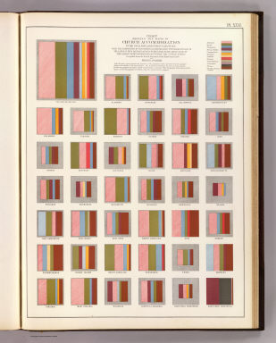
[United States. Census Office, Walker, Francis Amasa, 1840-1897]
Full Title
Chart showing the ratio of Church accommodation to the total population over 10 years of age with the proportion of such church accommodation furnished by each of the largest four denominations within each state and by each of the largest eight denominations within the United States. Compiled from the social statistics of the ninth census 1870. By Francis A. Walker. (Julius Bien, Lith., 1874)
Publisher
U.S.
Author
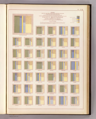
[United States. Census Office, Walker, Francis Amasa, 1840-1897]
Full Title
Chart showing for the United States and for each state with distinction of sex, the ratio between the total population over 10 years of age and the number of persons reported as engaged in each principal class of gainful occupations and also as attending school. Compiled from the returns of population at the ninth census 1870. By Francis A. Walker. (Julius Bien, Lith., 1874)
Publisher
U.S.
Author
[United States. Census Office, Walker, Francis Amasa, 1840-1897]
Full Title
Map showing the distribution of wealth. Compiled from the tables of "true valuation," ninth census of the United States, 1870. By Francis A. Walker. (Julius Bien, Lith., 1874)
Publisher
U.S.
Author
[United States. Census Office, Walker, Francis Amasa, 1840-1897]
Full Title
Map showing the degree of public indebtedness per capita. Contracted by state, county or municipal authority, at the close of the fiscal year nearest the census year. Compiled from the statistics of wealth, taxation and public indebtedness at the ninth census of the United States 1870. By Francis A. Walker. (Julius Bien, Lith., 1874)
Publisher
U.S.
Author
[United States. Census Office, Walker, Francis Amasa, 1840-1897]
Full Title
Map showing the degree of taxation per capita imposed by state, county or municipal authority, within the fiscal year nearest the census year. Compiled from the statistics of wealth, taxation and public indebtedness at the ninth census of the United States 1870. By Francis A. Walker. (Julius Bien, Lith., 1874)
Publisher
U.S.
Author
[United States. Census Office, Walker, Francis Amasa, 1840-1897]
Full Title
Fiscal chart of the United States showing the course of the public debt by years 1789 to 1870 together with the proportion of the total receipts from each principal source of revenue and the proportion of total expenditures for each principal department of the public service. Compiled from the report of the Secretary of the Treasury for the year 1872, by Francis A. Walker. (Julius Bien, Lith., 1874)
Publisher
U.S.
Author
[United States. Census Office, Walker, Francis Amasa, 1840-1897]
Full Title
Maps showing the range, and within the range, the degree of cultivation of certain principal crops. Compiled from the statistics of agriculture, ninth census 1870, by Francis A. Walker. (Julius Bien, Lith., 1874)
Publisher
U.S.
Author
[United States. Census Office, Walker, Francis Amasa, 1840-1897]
Full Title
Improved land in farms. Total agricultural production. Corn. Dairy products. (By Francis A. Walker. Julius Bien, Lith., 1874)
Publisher
U.S.
Author
[United States. Census Office, Walker, Francis Amasa, 1840-1897]
Full Title
Map of predominating sex showing the local excess of males or of females in the distribution of population over the territory of the United States east of the 100th Meridian. Compiled from the statistics of population at the ninth census 1870. By Francis A. Walker. (Julius Bien, Lith., 1874)
Publisher
U.S.
Author
[United States. Census Office, Walker, Francis Amasa, 1840-1897]
Full Title
Charts showing the distribution by age and sex of the population of the United States at the date of enumeration June 1st in the aggregate and with distinction of race, color and nativity for the United States and in the aggregate and as native or foreign for each state and territory. Compiled from the returns of population at the ninth census 1870 by Francis A. Walker. To which are added ... figures for 1850 and 1860 ... (Julius Bien, Lith., 1874)
Publisher
U.S.
Full Title
(Charts showing the distribution by age and sex of the population of the United States at the date of enumeration June 1st in the aggregate and with distinction of race, color and nativity for the United States and in the aggregate and as native or foreign for each state and territory. Compiled from the returns of population at the ninth census 1870 by Francis A. Walker. To which are added ... figures for 1850 and 1860 ... Julius Bien, Lith., 1874)
Publisher
U.S.
Author
[United States. Census Office, Walker, Francis Amasa, 1840-1897]
Full Title
Map showing, in five degrees of density, the birth rate prevailing in the territory of the United States east of the 100th Meridian, so far as the same is indicated by the ratio between the total population and the number of children under one year of age surviving at the date of enumeration, June 1st. Compiled from the returns of population at the ninth census of the United States, 1870. By Francis A. Walker. (Julius Bien, Lith., 1874)
Publisher
U.S.
Author
[United States. Census Office, Walker, Francis Amasa, 1840-1897]
Full Title
Map showing the proportion of deaths from consumption to deaths from all causes. Compiled from the returns of mortality at the ninth census of the United States 1870. By Francis A. Walker. (Julius Bien, Lith., 1874)
Publisher
U.S.
Author
[United States. Census Office, Walker, Francis Amasa, 1840-1897]
Full Title
Map showing the proportion of deaths from malarial diseases to deaths from all causes. Compiled from the returns of mortality at the ninth census of the United States 1870. By Francis A. Walker. (Julius Bien, Lith., 1874)
Publisher
U.S.
Author
[United States. Census Office, Walker, Francis Amasa, 1840-1897]
Full Title
Chart showing the distribution by age and sex of the deaths occurring during the census year, ending June 1st, compiled from the returns of mortality at the ninth census 1870. By Francis A. Walker. (Julius Bien, Lith., 1874)
Publisher
U.S.
Author
[United States. Census Office, Walker, Francis Amasa, 1840-1897]
Full Title
Chart showing the distribution of the deaths occurring during the census year, ending June 1st by sex and month of death and according to race and nationality, compiled from the returns of mortality at the ninth census 1870. By Francis A. Walker. (Julius Bien, Lith., 1874)
Publisher
U.S.
Author
[United States. Census Office, Walker, Francis Amasa, 1840-1897]
Full Title
Map showing the proportion of deaths from intestinal diseases to deaths from all causes. Compiled from the returns of mortality at the ninth census of the United States 1870. By Francis A. Walker. (Julius Bien, Lith., 1874)
Publisher
U.S.
Author
[United States. Census Office, Walker, Francis Amasa, 1840-1897]
Full Title
Map showing the proportion of deaths from enteric, cerebro-spinal and typhus fevers to deaths from all causes. Compiled from the returns of mortality at the ninth census of the United States 1870. By Francis A. Walker. (Julius Bien, Lith., 1874)
Publisher
U.S.
Author
[Brewer, William H., United States. Census Office]
Full Title
Map showing in five degrees of density the distribution of woodland within the territory of the United States, 1873. Compiled by Wm. H. Brewer. (Julius Bien, Lith., 1874)
Publisher
U.S.
Author
[Henry, Joseph, 1797-1878, Schott, Charles A. (Charles Anthony), 1826-1901, United States. Census Office]
Full Title
Rain chart of the United States. Showing the distribution by isohyetal lines of the mean precipitation in rain and melted snow for the year. Constructed under the direction of Prof. Joseph Henry, Sec'y. Smithsonian Institution from materials collected and observations made for the Smithsonian Institution by Chas. A. Schott, Asst., U.S. Coast Survey, with additions to 1872. (Julius Bien, Lith., 1874)
Publisher
U.S.
Author
[United States. Army. Signal Service, United States. Census Office]
Full Title
U.S. Signal Service chart showing the frequency of storm centres. Number of storm centres passing over each point deduced from the average of the two years March 1871 to February 1873 inclusive. Compiled from data collected at the Office of the Chief Signal Officer of the Army. (Julius Bien, Lith., 1874)
Publisher
U.S.
Author
[Henry, Joseph, 1797-1878, Schott, Charles A. (Charles Anthony), 1826-1901, United States. Census Office]
Full Title
Temperature chart of the United States. Showing the distribution by isothermal lines of the mean temperature for the year. Constructed under the direction of Prof. Joseph Henry, Sec'y. Smithsonian Institution by Chas. A. Schott, Asst., U.S. Coast Survey in October, 1872. (Julius Bien, Lith., 1874)
Publisher
U.S.
Author
[United States. Army. Signal Service, United States. Census Office]
Full Title
U.S. Signal Service chart showing the mean temperature. At 4.35 P.M. of the hottest week of 1872, in red, and at 7.35 A.M. of the coldest week of 1872 and 1873, in blue. Compiled from data collected at the Office of the Chief Signal Officer of the Army. (Julius Bien, Lith., 1874)
Publisher
U.S.
Author
[United States. Army. Signal Service, United States. Census Office]
Full Title
U.S. Signal Service chart, showing annual means of barometer and total movement of air with resultants from June 1872 to May 1873 inclusive. Compiled from data collected at the Office of the Chief Signal Officer of the Army. (Julius Bien, Lith., 1874)
Publisher
U.S.
Author
[Guyot, A. (Arnold), 1807-1884, Schott, Charles A. (Charles Anthony), 1826-1901, United States. Census Office]
Full Title
Hypsometric sketch of the United States. The level curves of 400 and 800 feet of elevation constructed by A. Guyot. The level curves of 2000, 4000 and 8000 feet of elevation constructed by Chas. A. Schott, Asst., U.S. Coast Survey. (Julius Bien, Lith., 1874)
Publisher
U.S.
Author
[Blake, William P. (William Phipps), 1826-1910, Hitchcock, Charles H. (Charles Henry), 1836-1919, United States. Census Office]
Full Title
Geological map of the United States compiled by C.H. Hitchcock and W.P. Blake from sources mentioned in the text. 1874. Lith. by J. Bien, N.Y.
Publisher
U.S.
Author
[Stocking, S. W., United States. Census Office]
Full Title
Map showing the acquisition of territory and its distribution among political divisions, 1776-1874. Compiled by S.W. Stocking. (with) Alaska. (Julius Bien, Lith., 1874)
Publisher
U.S.
Author
[Galpin, S. A., United States. Census Office]
Full Title
Maps of the Pacific Coast exhibiting various subjects. Compiled from the statistics of the eight and ninth census of the United States by S.A. Galpin. (Julius Bien, Lith., 1874)
Publisher
U.S.
Author
Wines, Frederick Howard
Full Title
Chart showing the distribution by age and sex of blindness. Prepared for the statistical atlas of the United States by Fred H. Wines, Secy. Illinois State Board of Charities. Ninth census 1870 ... Eighth census 1860. (Julius Bien, Lith., 1874)
Publisher
U.S.
|