Who What Where WhenREMOVE |
REFINE
Browse All : School Atlas and Atlas Map by Willard, Emma
1-30 of 30
Author
Willard, Emma
Full Title
Introductory Map. To Accompany Willard's History Of The United States. Locations and Wanderings Of The Aboriginal Tribes. (Arrow) Shows The Direction Of their Wanderings. Engraved & Printed by Saml. Maverick.
Publisher
White, Gallaher, & White
Author
Willard, Emma
Full Title
First Map Or Map Of 1578. To Accompany Willard's History Of The United States. (Inset) Queen Elizabeth Signs for Sir Humphrey Gilbert. The First patent Granted by an English Sovereign to Lands Within the Territory of the United States 1578. Engraved & Printed by Saml. Maverick.
Publisher
White, Gallaher, & White
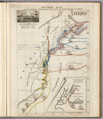
Author
Willard, Emma
Full Title
Second Map. To Accompany Willard's History Of The United States 1620. (Inset) The Pilgrims Land at Plymouth on the 22nd. of Dec. 1620. (inset map) Places Near The Mouth of the Hudson Visited by the Dutch. Engraved & Printed by Saml. Maverick.
Publisher
White, Gallaher, & White
Author
Willard, Emma
Full Title
Third Map or Map Of 1643. To Accompany Willard's History Of The United States. (Inset) The Commencement of the Confederacy in the Union of Plymouth and Massachusetts and New Haven and Connecticut 1643. (inset map) Places Mentioned in the History of the Pequod War. Engraved & Printed by Saml. Maverick N.Y.
Publisher
White, Gallaher, & White
Author
Willard, Emma
Full Title
Fourth Map or Map Of 1692. To Accompany Willard's History Of The United States. (Inset) Massachusetts Receives a New Charter, Including Maine and Other Large Territories by the Arrival of Sir Wm. Phipps. (inset map) Places Mentioned in the History of King Philip's War. (Engraved & Printed by) Saml. Maverick & Co. N.Y.
Publisher
White, Gallaher, & White
Author
Willard, Emma
Full Title
Fifth Map or Map Of 1733. To Accompany Willard's History Of The United States. (Inset) Genl. Oglethorpe with a Colony Commence the Settlement of Georgia 1733. He meets the Indian Chief's in Council at Savannah. (Engraved & Printed by) Saml. Maverick & Co. N.Y.
Publisher
White, Gallaher, & White
Author
Willard, Emma
Full Title
Sixth Map or Map Of 1763. To Accompany Willard's History Of The United States. (Inset) The Death of Gen. Wolf Occurs at the Time of Quebec's Being Taken by the English ... that leads to the Peace of Paris 1763. (inset map) Quebec. Engraved & Printed by Saml. Maverick.
Publisher
White, Gallaher, & White
Author
Willard, Emma
Full Title
Seventh Map or Map Of 1776. To Accompany Willard's History Of The United States. (Inset) A Committee of Five draw up the Declaration of Independence. 1776. (inset map) Boston and Vicinity. (inset) (untitle map showing Lake George and surroundings). (inset) Charleston and Vicinity. Engraved & Printed by Saml. Maverick &Co. N.Y.
Publisher
White, Gallaher, & White
Author
Willard, Emma
Full Title
Eighth Map or Map Of 1789. To Accompany Willard's History Of The United States. (Inset) Federal Government Commen CD 1789. (2 untitled inset maps). (Engraved & Printed by) Saml. Maverick & Co. N.Y.
Publisher
White, Gallaher, & White
Author
Willard, Emma
Full Title
Principal Seat of the Revolutionary War in the Southern Section of the U.S. To Accompany Willard's History Of The United States. (inset map) Principal Seat of the Revolutionary War in the northern section of the U.S. Engraved & Printed by Saml. Maverick.
Publisher
White, Gallaher, & White
Author
Willard, Emma
Full Title
Ninth Map Or Map Of 1826. To Accompany Willard's History Of The United States. Referred to in the History, As the Map of the President Day. 1826. Saml. Maverick & Co. N.Y.
Publisher
White, Gallaher, & White
Author
Willard, Emma
Full Title
Principal Seat of the War of 1812-13-14. To Accompany Willard's History Of The United States. Engraved & Printed by Saml. Maverick. N.Y.
Publisher
White, Gallaher, & White
Author
Willard, Emma
Full Title
The Ancient World According to Strabo. (Accompany) Ancient Geography, As Connected With Chronology, And Preparatory to the Study of Ancient History: By Emma Willard ... Hartford: Oliver D. Cooke & Sons. 1824. (on verso) ... on the eleventh day of June ... (1824). (with) A System of Universal Geography, On The Principles of Comparison and Classification; By William Channing Woodbridge ... Illustrated With Maps and Engravings; And Accompanied by an Atlas ... William C. Woodbridge ... and Emma Willard ... have deposited ... a Book ... Connecticut.
Publisher
Oliver D. Cooke & Sons
Author
Willard, Emma
Full Title
Map No. 1. Countries Known To The Ancients. So Arranged as to Show by the Characters & Colours Used during Which of the Six Epocha's into Which Ancient Time is Divided, Each Century Become Known. Entered according to act of Congress 5th. Day of September 1827 by Oliver D. Cooke & Co. of the State of Connecticut.
Publisher
Belknap and Hamersley
Author
Willard, Emma
Full Title
Map No. II. The World As Known To The Ancients. The Modern Name of Places Inserted on this Map... Placed under the Ancient names... Entered according to act of Congress 5th. Day of September 1827 by Oliver D. Cooke & Co. of the State of Connecticut.
Publisher
Belknap and Hamersley
Author
Willard, Emma
Full Title
Map No. III. Italy, Greece, Asia Minor, Syria. The Modern Name of Places Inserted on this Map... Placed under the Ancient names... Entered according to act of Congress 5th. Day of September 1827 by Oliver D. Cooke & Co. of the State of Connecticut.
Publisher
Belknap and Hamersley
Author
Willard, Emma
Full Title
Craecia Antiqua. Map No. IV. The Modern Name of Places Inserted on this Map... Placed under the Ancient names... Entered according to act of Congress 5th. Day of September 1827 by Oliver D. Cooke & Co. of the State of Connecticut. (inset map) Creta.
Publisher
Belknap and Hamersley
Author
Willard, Emma
Full Title
Mesopotamia Assyria, Babylonia Chaldea. Map No. V. Entered according to act of Congress 5th. Day of September 1827 by Oliver D. Cooke & Co. of the State of Connecticut. (inset map) Palestine.
Publisher
Belknap and Hamersley
Author
Willard, Emma
Full Title
Map No. VI. Migrations, Settlements &c Of Barbarous Tribes. Illustrating the Account which is given to Them in Willard's Ancient Geography. (arrow on the map) Shows the direction of the Wondering Tribes. Entered according to act of Congress 5th. Day of September 1827 by Oliver D. Cooke & Co. of the State of Connecticut.
Publisher
Belknap and Hamersley
Author
Woodbridge, William C.
Full Title
Counties Of England. (Accompany) A System of Universal Geography, On The Principles of Comparison and Classification; By William Channing Woodbridge ... Illustrated With Maps and Engravings; And Accompanied by an Atlas ... (with) Ancient Geography, As Connected With Chronology, And Preparatory to the Study of Ancient History: By Emma Willard ... Hartford: Oliver D. Cooke & Sons. 1824. (on verso) ... on the eleventh day of June ... (1824) ... William C. Woodbridge ... and Emma Willard ... have deposited ... a Book ... Connecticut.
Publisher
Oliver D. Cooke & Sons
Author
Woodbridge, William C.
Full Title
German States. (Accompany) A System of Universal Geography, On The Principles of Comparison and Classification; By William Channing Woodbridge ... Illustrated With Maps and Engravings; And Accompanied by an Atlas ... (with) Ancient Geography, As Connected With Chronology, And Preparatory to the Study of Ancient History: By Emma Willard ... Hartford: Oliver D. Cooke & Sons. 1824. (on verso) ... on the eleventh day of June ... (1824) ... William C. Woodbridge ... and Emma Willard ... have deposited ... a Book ... Connecticut.
Publisher
Oliver D. Cooke & Sons
Full Title
The World. (By William C. Woodbridge of the state of Connecticut. 1824?)
Publisher
Oliver D. Cook & Sons
Author
Woodbridge, William C.
Full Title
Chart of the inhabited World; exhibiting the prevailing religion, form of government, degree of civilization & population of each country. Entered ... 1821 by William C. Woodbridge of the state of Connecticut. (1824?)
Publisher
Oliver D. Cook & Sons
Author
Woodbridge, William C.
Full Title
North America. Entered ... 1821 by William C. Woodbridge of the state of Connecticut. (1824?)
Publisher
Oliver D. Cook & Sons
Author
Woodbridge, William C.
Full Title
United States. Entered ... 1821 by William C. Woodbridge of the state of Connecticut. (1824?)
Publisher
Oliver D. Cook & Sons
Author
Woodbridge, William C.
Full Title
South America. Entered ... 1821 by William C. Woodbridge of the state of Connecticut. (1824?)
Publisher
Oliver D. Cook & Sons
Author
Woodbridge, William C.
Full Title
Europe. Entered ... 1821 by William C. Woodbridge of the state of Connecticut. (1824?)
Publisher
Oliver D. Cook & Sons
Author
Woodbridge, William C.
Full Title
Asia. (with) Australasia. Entered ... 1821 by William C. Woodbridge of the state of Connecticut. (1824?)
Publisher
Oliver D. Cook & Sons
Author
Woodbridge, William C.
Full Title
Africa. Entered ... 1821 by William C. Woodbridge of the state of Connecticut. (1824?)
Publisher
Oliver D. Cook & Sons
Author
Woodbridge, William C.
Full Title
Isothermal chart, or view of climates & production, drawn from the accounts of Humboldt & others, by W.C. Woodbridge. Entered ... 1823 by William C. Woodbridge of the state of Connecticut. (1824?)
Publisher
Oliver D. Cook & Sons
1-30 of 30
|