Browse All

1811 General chart. World Atlas A general chart exhibiting the discoveri … |

1811 (Colombia Prima, S. America) N sheet. World Atlas (Colombia Prima or South America. North … |

1811 Colombia Prima, S. America. S sheet. World Atlas Colombia Prima or South America. (South … |

1802 E. Hemisphere. World Atlas Eastern Hemisphere. London, published by … |

1802 W. Hemisphere. World Atlas Western Hemisphere. London, published by … |
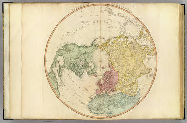
1802 N. Hemisphere. World Atlas Northern Hemisphere. London, published b … |

1802 S. Hemisphere. World Atlas Southern Hemisphere. London, published b … |

1791 Europe. World Atlas Europe, exhibiting its principal states … |

1801 England, Wales, Scotland. World Atlas A map of England, Wales & Scotland, desc … |

1778 N. Britain, Scotland. World Atlas North Britain or Scotland, divided into … |

1798 Ireland. World Atlas A map of Ireland divided into provinces … |

1781 Jersey, Guernsey. World Atlas A chart of the islands of Jersey and Gue … |

1794 Seven United Provinces. World Atlas A map of the Seven United Provinces with … |

1789 Netherlands or Low Countries. World Atlas A map of the Austrian possessions in the … |

1790 France. World Atlas France, divided into provinces. By W. Fa … |

1792 France. World Atlas France, divided into metropolitan circle … |

1795 N. France. World Atlas A map of the northern part of France, wi … |

1799 SE France. World Atlas The southeastern part of France which in … |

1796 Spain, Portugal. World Atlas Spain and Portugal; divided into their r … |

1797 Portugal. World Atlas Chorographical map of the Kingdom of Por … |

1785 Mediterranean W. World Atlas A map of the Mediterranean Sea with the … |

1785 Mediterranean E. World Atlas (A map of the Mediterranean Sea with the … |

1783 Gibraltar. World Atlas Plan of the bay, rock and town of Gibral … |

1800 Italy N. World Atlas Italy with the addition of the southern … |

1800 Italy S. World Atlas (Italy with the addition of the southern … |

1799 Suisse. World Atlas Nouvelle carte de la Suisse dans laquell … |

1788 German Empire. World Atlas A new map of the German Empire, and the … |

1788 German Empire. World Atlas A new map of the German Empire, and the … |

1789 Brunswick-Luneburg. World Atlas A new map of the King of Great Britain's … |

1799 Poland, Prussia. World Atlas A map of the Kingdom of Poland and Grand … |

1794 Scandia, Scandinavia. World Atlas Scandia or Scandinavia, comprehending Sw … |

1790 Denmark. World Atlas A map of the Kingdom of Denmark, with th … |

1804 Holstein. World Atlas A map of the Dutchy of Holstein, with th … |

1799 Russian Empire. World Atlas A new map of the Russian Empire, divided … |

1795 Turkey In Europe. World Atlas European dominions of the Ottomans, or T … |

1791 Greece, Anadoli. World Atlas Greece, Archipelago and part of Anadoli. … |

1808 Asia. World Atlas Asia. London, published by W. Faden, Geo … |

1794 Turkey in Asia. World Atlas A new map of Turkey in Asia by Monsr. d' … |

1800 Hind, Hindoostan, or India. World Atlas Hind, Hindoostan, or India. By L.S. de l … |

1786 Bengal, Bahar, Oude, Allahabad. World Atlas A map of Bengal, Bahar, Oude & Allahabad … |

1800 India peninsula N. World Atlas (A map of the peninsula of India from th … |

1800 India peninsula S. World Atlas A map of the peninsula of India from the … |

1803 Africa. World Atlas Africa. Auctor L.S. de la Rochette, 1782 … |

1802 Lower Egypt, Palestine. World Atlas Lower Egypt and the adjacent deserts, wi … |

1795 Cape of Good Hope. World Atlas The Dutch Colony of the Cape of Good Hop … |

1797 America. World Atlas A map of America or the New World, where … |

1808 NW America, NE Asia. World Atlas Chart of the N.W. coast of America and t … |

1796 United States Of North America. World Atlas The United States of North America: with … |

1796 West India Islands. World Atlas A general chart of the West India Island … |

1784 Antilles, Charibbee Islands. World Atlas A chart of the Antilles, or Charibbee, o … |