Who What Where WhenREMOVEWHOWHEN |
Author
Bowen, Emanuel
Full Title
The Solar System, with the orbits of 5 remarkable comets. (By Emanuel Bowen. London: Printed for William Innys, Richard Ware, Aaron Ward, J. and P. Knapton, John Clarke, T. Longman and T. Shewell, Thomas Osborne, Henry Whitridge ... M.DCC.XLVII)
Publisher
William Innys [et al.]
Author
Bowen, Emanuel
Full Title
A circle of winds consisting of 32 points commonly called the mariners compass. The artificial sphere. (By Emanuel Bowen. London: Printed for William Innys, Richard Ware, Aaron Ward, J. and P. Knapton, John Clarke, T. Longman and T. Shewell, Thomas Osborne, Henry Whitridge ... M.DCC.XLVII)
Publisher
William Innys [et al.]
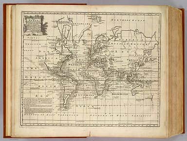
Author
Bowen, Emanuel
Full Title
A new & accurate chart of the world. Drawn from authentic surveys, assisted by the most approved modern maps & charts & regulated by astronl. observations, whereon are described lines, shewing the variation of the magnetical needle, according to observations made by several experienced navigators about the year 1744. By Eman: Bowen, Geographer to His Majesty. (London: Printed for William Innys, Richard Ware, Aaron Ward, J. and P. Knapton, John Clarke, T. Longman and T. Shewell, Thomas Osborne, Henry Whitridge ... M.DCC.XLVII)
Publisher
William Innys [et al.]
Author
Bowen, Emanuel
Full Title
A new and accurate map of Europe. Collected from the best authorities, assisted by the most approv'd modern maps & charts. The whole being regulated & adjusted by astronl. observations, by Emanl. Bowen. (London: Printed for William Innys, Richard Ware, Aaron Ward, J. and P. Knapton, John Clarke, T. Longman and T. Shewell, Thomas Osborne, Henry Whitridge ... M.DCC.XLVII)
Publisher
William Innys [et al.]
Author
Bowen, Emanuel
Full Title
A new and accurate map of Great Britain & Ireland, together with their respective islands &c. Drawn from surveys and the most approved maps and charts. The whole being regulated by astronomical observations, by Emanl. Bowen. (London: Printed for William Innys, Richard Ware, Aaron Ward, J. and P. Knapton, John Clarke, T. Longman and T. Shewell, Thomas Osborne, Henry Whitridge ... M.DCC.XLVII)
Publisher
William Innys [et al.]
Author
Bowen, Emanuel
Full Title
A new and very accurate map of South Britain, or England and Wales. Drawn from a great number of particular surveys, assisted by some of the most approved maps & charts. Containing all the cities, boroughs, market towns &c. With the principal direct & cross roads, also exhibiting the distances between the towns situated upon each road; together with the post stages &c. The whole being regulated by astronomical observatns. By Eman. Bowen. (London: Printed for William Innys, Richard Ware, Aaron Ward, J. and P. Knapton, John Clarke, T. Longman and T. Shewell, Thomas Osborne, Henry Whitridge ... M.DCC.XLVII)
Publisher
William Innys [et al.]
Author
Bowen, Emanuel
Full Title
A new & accurate map of Scotland or North Britain. Drawn from surveys and most approved maps and charts, & regulated by astronl. observns. With several imrovemts. not to be found in any other map extant. By Eman. Bowen. (London: Printed for William Innys, Richard Ware, Aaron Ward, J. and P. Knapton, John Clarke, T. Longman and T. Shewell, Thomas Osborne, Henry Whitridge ... M.DCC.XLVII)
Publisher
William Innys [et al.]
Author
Bowen, Emanuel
Full Title
A new and accurate map of Ireland. Laid down from the best authorities extant, and regulated by astronoml. observatns. By Emanl. Bowen. (London: Printed for William Innys, Richard Ware, Aaron Ward, J. and P. Knapton, John Clarke, T. Longman and T. Shewell, Thomas Osborne, Henry Whitridge ... M.DCC.XLVII)
Publisher
William Innys [et al.]
Author
Bowen, Emanuel
Full Title
A new and accurate map of France with its aquisitions, composed from the latest surveys, assisted by the most approved modern maps & charts, & regulated by astronl. observatns. By Emanl. Bowen. (London: Printed for William Innys, Richard Ware, Aaron Ward, J. and P. Knapton, John Clarke, T. Longman and T. Shewell, Thomas Osborne, Henry Whitridge ... M.DCC.XLVII)
Publisher
William Innys [et al.]
Author
Bowen, Emanuel
Full Title
A new & accurate map of Spain and Portugal. Drawn from surveys assisted by ye. most approved modern maps and charts. The whole being regulated by astronomical observations. By Eman. Bowen. (London: Printed for William Innys, Richard Ware, Aaron Ward, J. and P. Knapton, John Clarke, T. Longman and T. Shewell, Thomas Osborne, Henry Whitridge ... M.DCC.XLVII)
Publisher
William Innys [et al.]
Author
Bowen, Emanuel
Full Title
A new and accurate map of Portugal. Composed from the latest improvemts. and adjusted by the most authentic astronl. observats. By Eman: Bowen. (London: Printed for William Innys, Richard Ware, Aaron Ward, J. and P. Knapton, John Clarke, T. Longman and T. Shewell, Thomas Osborne, Henry Whitridge ... M.DCC.XLVII)
Publisher
William Innys [et al.]
Author
Bowen, Emanuel
Full Title
A new & accurate map of the Netherlands or Low Countries. Laid down from the best authorities, assisted by the most approved modern maps and regulated by astronl. observations. By Eman. Bowen. (London: Printed for William Innys, Richard Ware, Aaron Ward, J. and P. Knapton, John Clarke, T. Longman and T. Shewell, Thomas Osborne, Henry Whitridge ... M.DCC.XLVII)
Publisher
William Innys [et al.]
Author
Bowen, Emanuel
Full Title
A new and accurate map of the Seven United Provinces. Compiled from the most approv'd maps & charts and adjusted by astronoml. observations. By Emanl. Bowen. (London: Printed for William Innys, Richard Ware, Aaron Ward, J. and P. Knapton, John Clarke, T. Longman and T. Shewell, Thomas Osborne, Henry Whitridge ... M.DCC.XLVII)
Publisher
William Innys [et al.]
Author
Bowen, Emanuel
Full Title
A new & accurate map of Germany, divided into its circles & drawn from the most approv'd maps &c. and regulated by astronoml. observatns. By Emanl. Bowen. (London: Printed for William Innys, Richard Ware, Aaron Ward, J. and P. Knapton, John Clarke, T. Longman and T. Shewell, Thomas Osborne, Henry Whitridge ... M.DCC.XLVII)
Publisher
William Innys [et al.]
Author
Bowen, Emanuel
Full Title
A new & accurate map of the South West part of Germany. Comprehending the Archbishopricks of Mentz and Treves; the Electoral Palat: of the Rhine; Duchy of Wirtemberg; Franconia, Swabia, Alsace, Lorrain &c. Drawn from the best authorities and most approved maps and regulated by astronl. observations. By Emanl. Bowen. (London: Printed for William Innys, Richard Ware, Aaron Ward, J. and P. Knapton, John Clarke, T. Longman and T. Shewell, Thomas Osborne, Henry Whitridge ... M.DCC.XLVII)
Publisher
William Innys [et al.]
Author
Bowen, Emanuel
Full Title
A new & accurate map of the South East part of Germany, containing the Electorate of Bavaria, A.Bp. of Saltzburg, K. of Bohemia, with the Queen of Hungary's hereditary dominions of Austria, Moravia, Styria, Carinthia, Carniola, Trent, Tirol. &c. Drawn from the best authorities & most approv'd maps, & regulated by astronomical observations. By Emanl. Bowen. (London: Printed for William Innys, Richard Ware, Aaron Ward, J. and P. Knapton, John Clarke, T. Longman and T. Shewell, Thomas Osborne, Henry Whitridge ... M.DCC.XLVII)
Publisher
William Innys [et al.]
Author
Bowen, Emanuel
Full Title
A new & accurate map of the North East part of Germany, containing the dominions of the Electors of Saxony & Brandenburg with Silesia, ceded to the K. of Prussia by the Treaty of Breslaw. Also the Duchys of Mecklenburg, Pomerania &c. Laid down from the best authorities & most approv'd maps, & adjusted by astronomical observations. By Emanl. Bowen. (London: Printed for William Innys, Richard Ware, Aaron Ward, J. and P. Knapton, John Clarke, T. Longman and T. Shewell, Thomas Osborne, Henry Whitridge ... M.DCC.XLVII)
Publisher
William Innys [et al.]
Author
Bowen, Emanuel
Full Title
A new & accurate map of the North West part of Germany, containing Westphalia & Lowr. Saxony, wherein are included ye. domins. of ye. Electors of Brunswick Lunenburg or Hannover Cologne &c., Landgrave of Hesse, Duchys of Holstein, Juliers &c., with the Bishopricks of Munster, Osnabrug &c. Laid down from the best authorities and regulated by astronomical observations. By Emanl. Bowen. (London: Printed for William Innys, Richard Ware, Aaron Ward, J. and P. Knapton, John Clarke, T. Longman and T. Shewell, Thomas Osborne, Henry Whitridge ... M.DCC.XLVII)
Publisher
William Innys [et al.]
Author
Bowen, Emanuel
Full Title
A new & accurate map of Switzerland with its allies and subjects. Composed from ye. most approv'd maps &c. and regulated by astronoml. observatns. By Emanl. Bowen. (London: Printed for William Innys, Richard Ware, Aaron Ward, J. and P. Knapton, John Clarke, T. Longman and T. Shewell, Thomas Osborne, Henry Whitridge ... M.DCC.XLVII)
Publisher
William Innys [et al.]
Author
Bowen, Emanuel
Full Title
A new and accurate map of Savoy, Piemont, and Montferrat. Exhibiting the present seat of war. Collected from the best authorities and most approved modern maps. The whole being regulated by astronl. observations. By Eman. Bowen. (London: Printed for William Innys, Richard Ware, Aaron Ward, J. and P. Knapton, John Clarke, T. Longman and T. Shewell, Thomas Osborne, Henry Whitridge ... M.DCC.XLVII)
Publisher
William Innys [et al.]
Author
Bowen, Emanuel
Full Title
A new and accurate map of Italy. Drawn from the latest and best authorities, and regulated by the most approved astronl. observations. By Eman. Bowen. (London: Printed for William Innys, Richard Ware, Aaron Ward, J. and P. Knapton, John Clarke, T. Longman and T. Shewell, Thomas Osborne, Henry Whitridge ... M.DCC.XLVII)
Publisher
William Innys [et al.]
Author
Bowen, Emanuel
Full Title
A new and accurate map of the northern parts of Italy. Comprehending Savoy, Piemont, Milan, Parma, Mantua, Modena, Tuscany, with the Republicks of Venice, Genoa and Lucca. Drawn from the latest & best authorities & regulated by astronl. obserns. By Emanl. Bowen. (London: Printed for William Innys, Richard Ware, Aaron Ward, J. and P. Knapton, John Clarke, T. Longman and T. Shewell, Thomas Osborne, Henry Whitridge ... M.DCC.XLVII)
Publisher
William Innys [et al.]
Author
Bowen, Emanuel
Full Title
A new & accurate map of the Kingdoms of Naples & Sicily. Drawn from the most approv'd foreign maps & charts, and regulated by astronl. observations. By Emanl. Bowen. (London: Printed for William Innys, Richard Ware, Aaron Ward, J. and P. Knapton, John Clarke, T. Longman and T. Shewell, Thomas Osborne, Henry Whitridge ... M.DCC.XLVII)
Publisher
William Innys [et al.]
Author
Bowen, Emanuel
Full Title
A new and accurate map of Scandinavia, or the northern crowns of Sweden, Denmark, and Norway, drawn from the most approv'd maps and charts and adjusted by astronoml. observations. By Emanl. Bowen. (London: Printed for William Innys, Richard Ware, Aaron Ward, J. and P. Knapton, John Clarke, T. Longman and T. Shewell, Thomas Osborne, Henry Whitridge ... M.DCC.XLVII)
Publisher
William Innys [et al.]
Author
Bowen, Emanuel
Full Title
A new & accurate map of Negroland and the adjacent countries; also Upper Guinea, shewing the principal European settlements, & distinguishing wch. belong to England, Denmark, Holland &c. The sea coast & some of the rivers being drawn from surveys & the best modern maps and charts, & regulated by astron. observns. By Eman. Bowen. (London: Printed for William Innys, Richard Ware, Aaron Ward, J. and P. Knapton, John Clarke, T. Longman and T. Shewell, Thomas Osborne, Henry Whitridge ... M.DCC.XLVII)
Publisher
William Innys [et al.]
Author
Bowen, Emanuel
Full Title
A new & accurate map of the southern parts of Africa. Containing Lower Guinea, Monoemugi, Zanguebar, and Empire of Monomotapa, county of the Cafres &c. and the Isld. of Madagascar. Drawn from the best authorities, assisted by the most approved charts & maps & adjusted by astronl. observations. By Eman. Bowen. (London: Printed for William Innys, Richard Ware, Aaron Ward, J. and P. Knapton, John Clarke, T. Longman and T. Shewell, Thomas Osborne, Henry Whitridge ... M.DCC.XLVII)
Publisher
William Innys [et al.]
Author
Bowen, Emanuel
Full Title
Particular draughts of some of the chief African Islands in the Mediterranean, as also in the Atlantic and Ethiopic Oceans. By Eman. Bowen. (London: Printed for William Innys, Richard Ware, Aaron Ward, J. and P. Knapton, John Clarke, T. Longman and T. Shewell, Thomas Osborne, Henry Whitridge ... M.DCC.XLVII)
Publisher
William Innys [et al.]
Author
Bowen, Emanuel
Full Title
A new general map of America. Drawn from several accurate particular maps and charts, and regulated by astronomical observations. By Eman. Bowen. (London: Printed for William Innys, Richard Ware, Aaron Ward, J. and P. Knapton, John Clarke, T. Longman and T. Shewell, Thomas Osborne, Henry Whitridge ... M.DCC.XLVII)
Publisher
William Innys [et al.]
Author
Bowen, Emanuel
Full Title
A new & accurate map of Brasil. Divided into its captainships. Drawn from the most approved modern maps & charts, and regulated by astronomical observations. By Eman. Bowen. (London: Printed for William Innys, Richard Ware, Aaron Ward, J. and P. Knapton, John Clarke, T. Longman and T. Shewell, Thomas Osborne, Henry Whitridge ... M.DCC.XLVII)
Publisher
William Innys [et al.]
Author
Bowen, Emanuel
Full Title
A new and accurate map of Paraguay, Rio de la Plata, Tucumania, Guaria &c. Laid down from the latest improvements, and regulated by astronomical observations. By Eman: Bowen. (London: Printed for William Innys, Richard Ware, Aaron Ward, J. and P. Knapton, John Clarke, T. Longman and T. Shewell, Thomas Osborne, Henry Whitridge ... M.DCC.XLVII)
Publisher
William Innys [et al.]
Author
Bowen, Emanuel
Full Title
A new and accurate map of Chili, Terra Magellanica, Terra del Fuego &c. Laid down according to the latest improvements and regulated by astronl. observatns. By Eman: Bowen. (London: Printed for William Innys, Richard Ware, Aaron Ward, J. and P. Knapton, John Clarke, T. Longman and T. Shewell, Thomas Osborne, Henry Whitridge ... M.DCC.XLVII)
Publisher
William Innys [et al.]
Author
Bowen, Emanuel
Full Title
A new and accurate map of Peru, and the country of the Amazones. Drawn from the most authentick French maps &c. and regulated by astronomical observations. By Eman. Bowen. (London: Printed for William Innys, Richard Ware, Aaron Ward, J. and P. Knapton, John Clarke, T. Longman and T. Shewell, Thomas Osborne, Henry Whitridge ... M.DCC.XLVII)
Publisher
William Innys [et al.]
Author
Bowen, Emanuel
Full Title
A new and accurate map of Terra Firma and the Caribbe Islands. Drawn from the most approved modern maps & charts, & adjusted by astronl. observatns. By Eman. Bowen. (London: Printed for William Innys, Richard Ware, Aaron Ward, J. and P. Knapton, John Clarke, T. Longman and T. Shewell, Thomas Osborne, Henry Whitridge ... M.DCC.XLVII)
Publisher
William Innys [et al.]
Author
Bowen, Emanuel
Full Title
An accurate map of the West Indies. Drawn from the best authorities, assisted by the most approved modern maps and charts, and regulated by astronomical observations. By Eman: Bowen. (London: Printed for William Innys, Richard Ware, Aaron Ward, J. and P. Knapton, John Clarke, T. Longman and T. Shewell, Thomas Osborne, Henry Whitridge ... M.DCC.XLVII)
Publisher
William Innys [et al.]
Author
Bowen, Emanuel
Full Title
A new & accurate map of Mexico or New Spain together with California, New Mexico &c. Drawn from the best modern maps & charts & regulated by astronl. observns. By Eman: Bowen. (London: Printed for William Innys, Richard Ware, Aaron Ward, J. and P. Knapton, John Clarke, T. Longman and T. Shewell, Thomas Osborne, Henry Whitridge ... M.DCC.XLVII)
Publisher
William Innys [et al.]
Author
Bowen, Emanuel
Full Title
A new & accurate map of Louisiana, with part of Florida and Canada, and the adjacent countries. Drawn from surveys, assisted by the most approved English & French maps & charts. The whole being regulated by astronomical observations. By Eman. Bowen. (London: Printed for William Innys, Richard Ware, Aaron Ward, J. and P. Knapton, John Clarke, T. Longman and T. Shewell, Thomas Osborne, Henry Whitridge ... M.DCC.XLVII)
Publisher
William Innys [et al.]
Author
Bowen, Emanuel
Full Title
A new and accurate map of the island of Antigua or Antego, taken from surveys, and adjusted by astronl. observations. Containing all the towns, parish churches, forts, castles, windmills, roads &c. By Eman. Bowen. (London: Printed for William Innys, Richard Ware, Aaron Ward, J. and P. Knapton, John Clarke, T. Longman and T. Shewell, Thomas Osborne, Henry Whitridge ... M.DCC.XLVII)
Publisher
William Innys [et al.]
Author
Bowen, Emanuel
Full Title
Particular draughts and plans of some of the principal towns and harbours belonging to the English, French, and Spaniards, in America and West Indies. Collected from the best authorities, by Eman. Bowen. (London: Printed for William Innys, Richard Ware, Aaron Ward, J. and P. Knapton, John Clarke, T. Longman and T. Shewell, Thomas Osborne, Henry Whitridge ... M.DCC.XLVII)
Publisher
William Innys [et al.]
Author
Bowen, Emanuel
Full Title
An accurate map of the Island of Barbadoes. Drawn from an actual survey containing all the towns, churches, fortifications, roads, paths, plantations &c. By Eman. Bowen. (London: Printed for William Innys, Richard Ware, Aaron Ward, J. and P. Knapton, John Clarke, T. Longman and T. Shewell, Thomas Osborne, Henry Whitridge ... M.DCC.XLVII)
Publisher
William Innys [et al.]
Author
Bowen, Emanuel
Full Title
A new & accurate map of the North Pole, with all the countries hitherto discovered situated near or adjacent to it, as well as some others more remote. Drawn from the latest and best authorities and regulated by astronoml. observatns. By Eman. Bowen. (London: Printed for William Innys, Richard Ware, Aaron Ward, J. and P. Knapton, John Clarke, T. Longman and T. Shewell, Thomas Osborne, Henry Whitridge ... M.DCC.XLVII)
Publisher
William Innys [et al.]
Author
Bowen, Emanuel
Full Title
A map of old Greenland or Oster Bygd & Wester Bygd, agreeable to Egede's late description of Greenland. By Eman. Bowen. (London: Printed for William Innys, Richard Ware, Aaron Ward, J. and P. Knapton, John Clarke, T. Longman and T. Shewell, Thomas Osborne, Henry Whitridge ... M.DCC.XLVII)
Publisher
William Innys [et al.]
Author
Bowen, Emanuel
Full Title
(Title Page to) A complete system of geography. Being a description of all the countries, islands, cities, chief towns, harbours, lakes, and rivers, mountains, mines, &c. of the known world ... In two volumes. The whole illustrated with seventy maps, by Emanuel Bowen, Geographer to His Majesty, being all new-drawn and ingraved according to the latest discoveries and surveys; making, of themselves, a complete atlas, for the sse of gentlemen, merchants, mariners, and others, who delight in history and geography ... Vol. 1. London: Printed for William Innys, Richard Ware, Aaron Ward, J. and P. Knapton, John Clarke, T. Longman and T. Shewell, Thomas Osborne, Henry Whitridge ... M.DCC.XLVII.
Publisher
William Innys [et al.]
Author
Bowen, Emanuel
Full Title
(Index to) A complete system of geography. Being a description of all the countries, islands, cities, chief towns, harbours, lakes, and rivers, mountains, mines, &c. of the known world ... In two volumes. The whole illustrated with seventy maps, by Emanuel Bowen, Geographer to His Majesty, being all new-drawn and ingraved according to the latest discoveries and surveys; making, of themselves, a complete atlas, for the sse of gentlemen, merchants, mariners, and others, who delight in history and geography ... Vol. 1. London: Printed for William Innys, Richard Ware, Aaron Ward, J. and P. Knapton, John Clarke, T. Longman and T. Shewell, Thomas Osborne, Henry Whitridge ... M.DCC.XLVII.
Publisher
William Innys [et al.]
Author
Bowen, Emanuel
Full Title
(Title Page to) A complete system of geography. Being a description of all the countries, islands, cities, chief towns, harbours, lakes, and rivers, mountains, mines, &c. of the known world ... In two volumes. The whole illustrated with seventy maps, by Emanuel Bowen, Geographer to His Majesty, being all new-drawn and ingraved according to the latest discoveries and surveys; making, of themselves, a complete atlas, for the sse of gentlemen, merchants, mariners, and others, who delight in history and geography ...Vol. 2. London: Printed for William Innys, Richard Ware, Aaron Ward, J. and P. Knapton, John Clarke, T. Longman and T. Shewell, Thomas Osborne, Henry Whitridge ... M.DCC.XLVII.
Publisher
William Innys [et al.]
Author
Bowen, Emanuel
Full Title
A new & accurate map of the Islands of the Archipelago, together with the Morea, and the neighbouring countries in Greece &c. Drawn from the most approved modern maps & charts, & regulated by astronl. observatns. By Eman. Bowen. (London: Printed for William Innys, Richard Ware, Aaron Ward, J. and P. Knapton, John Clarke, T. Longman and T. Shewell, Thomas Osborne, Henry Whitridge ... M.DCC.XLVII)
Publisher
William Innys [et al.]
Author
Bowen, Emanuel
Full Title
A new & accurate map of Asia. Drawn from actual surveys, and otherwise collected from journals; assisted by the most approved modern maps & charts. The whole being regulated by astronl. observations. By Eman. Bowen. (London: Printed for William Innys, Richard Ware, Aaron Ward, J. and P. Knapton, John Clarke, T. Longman and T. Shewell, Thomas Osborne, Henry Whitridge ... M.DCC.XLVII)
Publisher
William Innys [et al.]
Author
Bowen, Emanuel
Full Title
A new & accurate map of Turky in Asia, Arabia &c. Drawn from the best authorities, assisted by the most approved modern maps & charts. The whole being regulated by astronl. observatns. By Eman: Bowen. (London: Printed for William Innys, Richard Ware, Aaron Ward, J. and P. Knapton, John Clarke, T. Longman and T. Shewell, Thomas Osborne, Henry Whitridge ... M.DCC.XLVII)
Publisher
William Innys [et al.]
Author
Bowen, Emanuel
Full Title
A new and accurate map of Anatolia or Asia Minor, with Syria and such other provinces of the Turkish Empire as border thereupon. Laid down according to the best authorities, & regulated by astronomical observations. By Eman. Bowen. (London: Printed for William Innys, Richard Ware, Aaron Ward, J. and P. Knapton, John Clarke, T. Longman and T. Shewell, Thomas Osborne, Henry Whitridge ... M.DCC.XLVII)
Publisher
William Innys [et al.]
Author
Bowen, Emanuel
Full Title
An accurate map of Asia Minor, as divided into its provinces, before it became posses'd by the Turks. Laid down from the most approved maps. By Eman. Bowen. (London: Printed for William Innys, Richard Ware, Aaron Ward, J. and P. Knapton, John Clarke, T. Longman and T. Shewell, Thomas Osborne, Henry Whitridge ... M.DCC.XLVII)
Publisher
William Innys [et al.]
Author
Bowen, Emanuel
Full Title
An accurate map of the Holy Land divided into the XII Tribes of Israel. Accommodated to Sacred History, & describing the travels of Jesus Christ. By Eman. Bowen. (London: Printed for William Innys, Richard Ware, Aaron Ward, J. and P. Knapton, John Clarke, T. Longman and T. Shewell, Thomas Osborne, Henry Whitridge ... M.DCC.XLVII)
Publisher
William Innys [et al.]
|