Browse All

1874 Tyrone. Altay. Weston, New York. County Atlas Tyrone, Town of Tyrone. Altay, Town of T … |

1845 Covers: School Atlas, To Accompany Moder … School Atlas (Covers to) Modern Atlas, Physical, Poli … |

1845 Title Page: Modern Atlas, Physical, Poli … School Atlas (Title Page to) Modern Atlas, Physical, … |

1845 Statistical Table: Geographical And Stat … School Atlas (Statistical Table to) Geographical And … |

1845 Statistical Table: Tables Of The Extent … School Atlas (Statistical Tables to) Tables Of The Ex … |

1845 Statistical Table: Tables Of The Extent … School Atlas (Statistical Tables to) Tables Of The Po … |

1845 Map Of The World School Atlas Map Of The World. Adapted To Woodbridge' … |

1845 Moral And Political Chart Of the Inhabit … School Atlas Moral And Political Chart Of the Inhabit … |

1845 Isothermal Chart Or View Of Climates School Atlas Isothermal Chart Or View Of Climates: Sh … |

1845 Political Map Of North America School Atlas Political Map Of North America. Adapted … |

1845 Physical Map Of North America School Atlas Physical Map Of North America. Adapted T … |

1845 Physical Map Of The United States. School Atlas Physical Map Of The United States. Adapt … |

1845 Political Map Of The United States, Mexi … School Atlas Political Map Of The United States, Mexi … |

1845 Physical & Political Map Of The North Ea … School Atlas Physical & Political Map Of The N. Easte … |

1845 Political Map Of the Northern Division O … School Atlas Political Map Of the Northern Division O … |

1845 Political Map Of the Southern Division O … School Atlas Physical & Political Map Of the Southern … |

1845 Physical Map Of America & Africa And The … School Atlas Physical Map Of America & Africa And The … |

1845 Political Map Of South America & Africa School Atlas Political Map Of South America and Afric … |

1845 Physical Map Of Europe School Atlas Physical Map Of Europe. Adapted To Woodb … |

1845 Political Map Of Europe School Atlas Political Map Of Europe. Adapted To Wood … |

1845 Political Map Of Great Britain And Irela … School Atlas Political Map Of Great Britain And Irela … |

1845 Political Map Of Germany School Atlas Political Map Of Germany. Adapted To Woo … |

1845 Physical Map Of Asia School Atlas Physical Map Of Asia. Adapted To Woodbri … |

1845 Political Map Of Asia School Atlas Political Map Of Asia. Adapted To Woodbr … |

1845 Oceanica And The Pacific Ocean School Atlas Oceanica And The Pacific Ocean. Adapted … |

1845 Comparative Chart Of The Extent Of Count … School Atlas Comparative Chart Of The Extent Of Count … |

1878 Covers: Howden & Odbert's Atlas Of Warre … County Atlas (Covers to) Howden & Odbert's Atlas Of W … |

1865 Map of Asia Showing its Gt. Political Di … World Atlas Map of Asia Showing its Gt. Political Di … |

1865 Map of Persia, Turkey in Asia. Afghanist … World Atlas Map of Persia, Turkey in Asia. Afghanist … |

1865 A New map of Palestine or the Holy Land World Atlas A New map of Palestine or the Holy Land. … |

1865 Map of Hindoostan, Farther India, China, … World Atlas Map of Hindoostan, Farther India, China, … |

1865 Map of Oceanica, exhibiting its Various … World Atlas Map of Oceanica, exhibiting its Various … |

1865 Map Of Africa, Showing Its Most Recent D … World Atlas Map Of Africa, Showing Its Most Recent D … |

1865 Covers: Mitchell's New General Atlas World Atlas (Covers to) Mitchell's New General Atlas … |

1865 Text Page: Dedication note to A.F. Scrut … World Atlas (Text Page to) Mitchell's New General At … |

1865 Title Page: Mitchell's New General Atlas World Atlas (Title Page to) Mitchell's New General A … |

1865 Contents: List of Maps World Atlas (Contents to) Mitchell's New General Atl … |

1865 The World in Hemispheres. With others Pr … World Atlas The World in Hemispheres. With others Pr … |

1865 A Time Table World Atlas A time table indicating the difference i … |

1865 Map of the World in Mercator projection World Atlas Map of the World in Mercator projection. … |

1865 Map of North America World Atlas Map of North America. Showing its politi … |

1865 County map of Nova Scotia, New Brounswic … World Atlas County map of Nova Scotia, New Brounswic … |

1865 Map of Canada East in Counties World Atlas Map of Canada East in Counties. Entered … |

1865 Map of Canada West in Counties World Atlas Map of Canada West in Counties. Entered … |

1865 Map of the United States, and Territorie … World Atlas Map of the United States, and Territorie … |
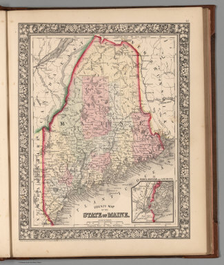
1865 County map of the State of Maine World Atlas County map of the State of Maine. Entere … |

1865 New Hampshire and Vermont World Atlas New Hampshire and Vermont. Drawn and Eng … |

1865 County map of Massachusetts, Connecticut … World Atlas County map of Massachusetts, Connecticut … |

1865 County map of the State of New York, New … World Atlas County map of the State of New York, New … |

1865 Plan of New York &c. World Atlas Plan of New York &c. Entered ... 1860 by … |