Search Results:

1895 Galveston, Charleston Harbor, Port Hudso … Military Atlas Galveston, Tex. and its fortifications. … |

1895 Rappahannock R., Chancellorsville, Frede … Military Atlas Map of the Rappahannock River from Port … |

1895 Carthage, Missouri. County Atlas Map of Carthage, County Seat of Jasper C … |

1895 Webb City and Carterville, Missouri. County Atlas Maps of the Cities of Webb City and Cart … |

1895 Joplin, Missouri. County Atlas Map of Joplin. |

1895 Missouri. County Atlas Missouri. (inset) (Vicinity of St. Louis … |

1895 Outline Map of Jasper County, Missouri. County Atlas Outline Map of Jasper County, Missouri. |

1895 Plat of Duval, Missouri. County Atlas Plat of Duval. |

1895 Plat of Galena, Missouri. Howard, Zincit … County Atlas Plat of Galena. Howard, Zincite P.O. Dub … |

1895 Plat of Jackson, Missouri. County Atlas Plat of Jackson. |

1895 Scotland. Burch Center. Burch City, Miss … County Atlas Scotland. Burch Center. Burch City. |

1895 Plat of Jasper, Missouri. County Atlas Plat of Jasper. |

1895 East Opolis. Galesburg, Missouri. County Atlas East Opolis. Galesburg. |

1895 (Plat of) Joplin, Missouri. County Atlas (Plat of) Joplin. |

1895 Asbury. Georgia City, Missouri. County Atlas Asbury. Georgia City. |

1895 Plat of Lincoln, Missouri. Medoc. County Atlas Plat of Lincoln. Medoc. |

1895 Plat of Madison, Missouri. County Atlas Plat of Madison. |

1895 Alba, Missouri. County Atlas Alba. |

1895 Plat of Marion, Missouri. County Atlas Plat of Marion. |

1895 Plat of a Part of Marion Township, Misso … County Atlas Plat of a Part of Marion Twp. |

1895 Plat of Mineral, Missouri. County Atlas Plat of Mineral. |

1895 Oronogo, Originally Minersville, Missour … County Atlas Oronogo, Originally Minersville. |

1895 Plat of McDonald, Missouri. County Atlas Plat of McDonald. |

1895 Avilla, Missouri. County Atlas Avilla. |

1895 Plat of Preston, Missouri. County Atlas Plat of Preston. |

1895 Preston, Brest P.O. Carytown, Originally … County Atlas Preston, Brest P.O. Carytown, Originally … |

1895 Jasper, Missouri. County Atlas Jasper. |

1895 Plat of Sarcoxie, Missouri. County Atlas Plat of Sarcoxie. |

1895 Reeds, Missouri. County Atlas Reeds. |

1895 West Part of Sarcoxie, Missouri. County Atlas West Part of Sarcoxie. |

1895 Plat of Sheridan, Missouri. County Atlas Plat of Sheridan. |

1895 Plat of Twin Groves, Missouri. County Atlas Plat of Twin Groves. |

1895 East Part of Sarcoxie. County Atlas East Part of Sarcoxie. |

1895 Waco, Missouri. County Atlas Waco. |

1895 Smithfield, Missouri. County Atlas Smithfield. |

1895 West Part of Carl Junction. County Atlas West Part of Carl Junction. |

1895 Plat of Union, Missouri. County Atlas Plat of Union. |

1895 East Part of Carl Junction, Missouri. County Atlas East Part of Carl Junction. |

1895 Principal Meridians and Base Lines in th … County Atlas Map Showing the Principal Meridians and … |

1895 United States. State Atlas Map of the United States. Reduced from t … |

1895 New York. State Atlas Map of the state of New York. Copyright … |

1895 N.Y. land grants, patents, purchases. State Atlas Map of the state of New York showing the … |

1895 NY rainfall, population, elevation, temp … State Atlas Map of the state of New York showing the … |

1895 N.Y., Kings, Queens, Richmond, Rockland, … State Atlas New York, Kings, Queens, Richmond, Rockl … |

1895 N.Y. City, Brooklyn. State Atlas City of New York. City of Brooklyn. Copy … |

1895 Suffolk County. State Atlas Suffolk County. Copyright 1895, Julius B … |

1895 Dutchess County. State Atlas Dutchess County. Copyright 1895, Julius … |

1895 Ulster, Orange counties. State Atlas Ulster and Orange counties. Copyright 18 … |

1895 Fulton, Montgomery, Schenectady, Schohar … State Atlas Fulton, Montgomery, Schenectady, Schohar … |
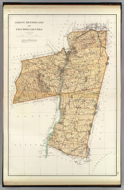
1895 Albany, Rensselaer, Columbia counties. State Atlas Albany, Rensselaer and Columbia counties … |