Search Results:

1840 A new map of New York with its canals, r … Guide Book A new map of New York with its canals, r … |

1840 A new map of Pennsylvania with its canal … Guide Book A new map of Pennsylvania with its canal … |

1840 Profile of the Erie Canal. Profile of th … Guide Book Profile of the Erie Canal N.Y. ; Profile … |

1840 Profile of the Florida Canal ; Morris Ca … Guide Book Florida Canal ; Morris Canal N. J. ; Uni … |

1840 Text Page: Catalogue of atlases, maps, a … Guide Book (Text Page to) Catalogue of atlases, map … |

1840 Text Page: (Continues) Catalogue of Text … Guide Book (Text Page to) Catalogue of atlases, map … |

1840 Text Page: (Continues) Catalogue of atla … Guide Book (Text Page to) Catalogue of atlases, map … |

1840 Map of the canals & railroads of the Uni … Guide Book Map of the canals & railroads of the Uni … |

1915 Canals, Lighthouses and sailing routes o … National Atlas Canals, Lighthouses and sailing routes o … |

1858 Covers: Carte D'Etude Pour Le Trace Et L … Survey Book (Covers to) Carte D'Etude Pour Le Trace … |

1858 Title Page: Carte D'Etude Pour Le Trace … Survey Book (Title Page to) Carte D'Etude Pour Le Tr … |

1858 TextPage: Trace et profils du canal de N … Survey Book (Text Page to) Trace et profils du canal … |
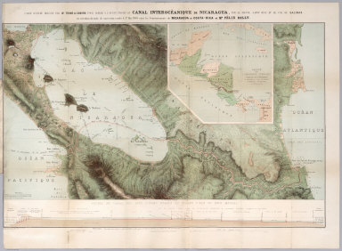
1858 Carte D'Etude Pour Le Trace Et Le Profil … Survey Book Carte d'etude dressee par Mr. Thome de G … |

1922 The West Indies. World Atlas The West Indies. (with) Panama Canal. (w … |

1834 Etats-Unis d'Amerique. National Atlas Carte generale des Etats-Unis d'Amerique … |

1834 Canal de la Chesapeake a l'Ohio. National Atlas Canal de la Chesapeake a l'Ohio. Plan ge … |

1834 Canal, Mississippi au Lac Pontchartrain. National Atlas Plan du canal de jonction du Mississippi … |

1834 Canal Morris. National Atlas Canal Morris. Plan du trace et profiles … |

1834 Canal du Cap-Cod. National Atlas Canal du Cap-Cod. Etat du Massachusetts. … |

1834 Floride, Delta du Mississippi canal. National Atlas Carte generale de la Floride et du Delta … |

1880 South America. World Atlas Map of South America, showing its politi … |

1890 Mexico, Central America, West Indies. World Atlas Map of Mexico, Central America, and the … |

1870 South America. [State Atlas, World Atlas] Map of South America, showing its politi … |

1801 England, Wales, Scotland. World Atlas A map of England, Wales & Scotland, desc … |

1838 United States, exhibiting the railroads … World Atlas United States, exhibiting the railroads … |

1838 Text page: Canals and railroads World Atlas (Text Page to) Canals and railroads. (to … |

1845 Maryland and Delaware National Atlas Maryland and Delaware. (inset) District … |

1832 New-York State, surrounding country. State Atlas Map of the State of New-York and the sur … |

1830 Title Page: Connected view of the whole … Geography Book (Title Page to) A Connected View of The … |

1830 A Connected View of The Whole Internal N … Geography Book A Connected View of The Whole Internal N … |

1837 England canals, railways. World Atlas England with its canals and railways. Pu … |

1897 Colombia, Venezuela. World Atlas Rand, McNally & Co.'s indexed atlas of t … |

1948 Great Lakes including Canals and Tributa … World Atlas The Northern and Northwestern Lakes incl … |

1912 Panama Canal. Military Atlas Profile of (Panama) Canal. Copyright 191 … |

1884 Mexico, Central America, West Indies. World Atlas Map of Mexico, Central America, and the … |

1886 Mexico, Central America, West Indies. World Atlas Map of Mexico, Central America, and the … |