Search Results:

1873 Livermore, Androscoggin County, Maine. L … County Atlas Livermore. (insets) Livermore Village. W … |

1873 Minot, Androscoggin County, Maine. County Atlas Minot. |

1873 Mechanic Falls, Androscoggin County, Mai … County Atlas Mechanic Falls. |

1873 Poland, Androscoggin County, Maine. Pola … County Atlas Poland, Androscoggin County, Maine. (ins … |

1873 Turner, Androscoggin County, Maine. County Atlas Turner. |

1873 Turner Village, Androscoggin County, Mai … County Atlas Turner Village. |

1873 Wales, Androscoggin County, Maine. County Atlas Wales. |

1873 South Turner. Lisbon Plains. Sabbasville … County Atlas South Turner. Lisbon Plains. Sabbasville … |

1873 Webster, Androscoggin County, Maine. County Atlas Webster. |

1875 Counties of St. John & Kings, New Brunsw … County Atlas Plan of the Counties of St. John & Kings … |
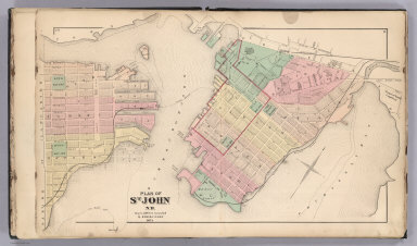
1875 St. John, N.B. (New Brunswick). County Atlas Plan of St. John, N.B. by Roe & Colby. ! … |

1875 St. John: Dukes & Sydney Wards. (New Bru … County Atlas Plan of St. John, Dukes & Sydney Wards. … |

1875 Plan of St. John, Queens Ward. (New Brun … County Atlas Plan of St. John, Queens Ward. (New Brun … |

1875 St. John: Kings Ward. (New Brunswick). County Atlas Plans of St. John, Kings Ward. (New Brun … |

1875 St. John: Wellington & Prince Wards. (Ne … County Atlas Plans of St. John, Wellington & Prince W … |

1875 St. John: Brooks Ward, Carleton. (New Br … County Atlas Plans of St. John, Brooks Ward, Carleton … |

1875 St. John: Guys & Albert Wards, Carleton. … County Atlas Plans of St. John, Guys & Albert Wards, … |

1875 Composite: St. John City. (New Brunswick … County Atlas (Composite of) St. John City. (New Bruns … |

1875 Portland (New Brunswick). County Atlas Town of Portland. (New Brunswick). |

1875 Portland, Village Plan No. 1. (New Bruns … County Atlas Portland, Village Plan No. 1. (New Bruns … |

1875 Portland, Village Plan No. 2. (New Bruns … County Atlas Portland, Village Plan No. 2. (New Bruns … |

1875 Portland, Village Plan No. 3. (New Bruns … County Atlas Portland, Village Plan No. 3. (New Bruns … |

1875 Portland, Village Plan No. 4. (New Bruns … County Atlas Portland, Village Plan No. 4. (New Bruns … |

1875 Parish of Lancaster. (New Brunswick). County Atlas Parish of Lancaster. (New Brunswick). |

1875 Part of the Parish of Lancaster No. 1. ( … County Atlas Part of the Parish of Lancaster No. 1. ( … |

1875 Part of the Parish of Lancaster No. 2. ( … County Atlas Part of the Parish of Lancaster No. 2. ( … |

1875 Fairville. (New Brunswick). County Atlas Fairville. (New Brunswick). |

1875 Musquash. (New Brunswick). County Atlas Musquash. (New Brunswick). |

1875 South Bay. (New Brunswick). County Atlas South Bay. (New Brunswick). |

1875 Parish of Simonds. (New Brunswick). County Atlas Parish of Simonds. (New Brunswick). |

1875 Part of Simonds including Crouchville, C … County Atlas Part of Simonds including Crouchville, C … |

1875 Parish of St. Martins. (New Brunswick). County Atlas Parish of St. Martins. (New Brunswick). |

1875 Quaco. (New Brunswick). County Atlas Quaco. (New Brunswick). |

1878 Railroad and Township Map of Kansas. County Atlas Rail Road and Township Map of Kansas. 18 … |

1878 Sectional Map of Leavenworth County, Kan … County Atlas Sectional Map of Leavenworth County, Kan … |

1878 Text: Patron's Directory (continued), Le … County Atlas (Text Page) Patron's Directory (continue … |

1878 Township 12 South, Range 22 E., Leavenwo … County Atlas Map of Township 12 South, Range 22 E. 6t … |

1878 Township 11 South, Range 22 E., Leavenwo … County Atlas Map of Township 11 South, Range 22 E. 6t … |

1878 Township 10 South, Range 22 E., Leavenwo … County Atlas Map of Township 10 South, Range 22 E. 6t … |

1878 Townships 9 and 10 South, Range 23 E., L … County Atlas Map of Township 9 & 10 South, Range 23 E … |

1878 Township 9 South, Range 22 E., Leavenwor … County Atlas Map of Township 9 South, Range 22 E. 6th … |

1878 Township 8 S, Range 22 & 23 E., Leavenwo … County Atlas Township 8 S, Range 22 & 23 E. 6th. P.M. |

1878 Tonganoxie. Fall Leaf. Kickapoo. Springd … County Atlas Tonganoxie. Fall Leaf. Kickapoo. Springd … |

1878 Townships 7 and 8 S. Range 21 E. 6th P.M … County Atlas Map of Townships 7 and 8 S. Range 21 E. … |

1878 Township 9 South, Range 21 East, Leavenw … County Atlas Map Township 9 South, Range 21 East 6 P. … |

1878 Township 10 South, Range 21 E., Leavenwo … County Atlas Map of Township 10 South, Range 21 E. 6t … |

1878 Township 11 South , Range 21 E., Leavenw … County Atlas Map of Township 11 South, Range 21 E. 6t … |

1878 Township 12 South, Ranges 21 E. and 20 E … County Atlas Map of Township 12 South, Range 21 E. 6t … |

1878 Townships 12 and 11 South, Range 20th E. … County Atlas Map of Township 12 South, Range 20 E. 6t … |

1878 Townships 10 and 9 South, Range 20 E., L … County Atlas Map of Townships 10 & 9 South, Range 20 … |