Search Results:

1876 Map of Gibson County. State Atlas Map of Gibson County. (Published by Bask … |

1876 Plan of Mount Vernon, Posey County (with … State Atlas Plan of Mount Vernon, Posey County. (wit … |

1876 Map of Posey County. State Atlas Map of Posey County. (Published by Baski … |

1876 St. Lawrence Catholic Church and School, … State Atlas St. Lawrence Catholic Church and School, … |

1876 Map of Vanderburgh County. State Atlas Map of Vanderburgh County. (Published by … |

1876 Plan of Evansville, Vanderburgh Co. State Atlas Plan of Evansville, Vanderburgh Co. (Pub … |

1876 Map of Floyd County. State Atlas Map of Floyd County. (Published by Baski … |

1876 Plan of the City of New Albany, Floyd Co … State Atlas Plan of the City of New Albany, Floyd Co … |

1876 Map of Crawford County. State Atlas Map of Crawford County. (Published by Ba … |

1876 Map of Warrick County. State Atlas Map of Warrick County. (Published by Bas … |

1876 Map of Spencer County. State Atlas Map of Spencer County. (Published by Bas … |

1876 Residence of the late Dr. Seth Hobbs ... … State Atlas Residence of the late Dr. Seth Hobbs ... … |

1876 Map of Perry County. State Atlas Map of Perry County. (Published by Baski … |

1876 Map of Dubois County. State Atlas Map of Dubois County. (Published by Bask … |

1876 Map of Harrison County. State Atlas Map of Harrison County. (Published by Ba … |

1876 Residence and mill of Samuel Cade, Wabas … State Atlas Residence and mill of Samuel Cade, Wabas … |

1876 Plan of Newburgh, Warrick Co. (with) Boo … State Atlas Plan of Newburgh, Warrick Co. (with) Pla … |

1876 Plan of Green Castle, Putnam Co. (with) … State Atlas Plan of Green Castle, Putnam Co. (with) … |

1876 Geological map of Indiana. Climatologica … State Atlas Geological map of Indiana. Climatologica … |

1876 Western Hemisphere. State Atlas Western Hemisphere. (Published by Baskin … |

1876 Eastern Hemisphere. State Atlas Eastern Hemisphere. (Published by Baskin … |

1876 Congressional districts. Judicial distri … State Atlas Congressional districts. Judicial distri … |

1876 Senatorial districts. Representative dis … State Atlas Senatorial districts. Representative dis … |

1876 New railroad map of the United States an … State Atlas New railroad map of the United States an … |

1876 Population - United States census, 1870. … State Atlas Population - United States census, 1870. … |

1876 Population - United States census, 1870. … State Atlas Population - United States census, 1870. … |

1876 Agricultural productions colored by grad … State Atlas Agricultural productions colored by grad … |

1876 Vital statistics, United States census, … State Atlas Vital statistics, United States census, … |

1876 Richmond Agricultural Works, Richmond, I … State Atlas Richmond Agricultural Works, Richmond, I … |

1876 New sectional and township map of Indian … State Atlas New sectional and township map of Indian … |

1876 Earlham College, Richmond, Ind. (with re … State Atlas Earlham College, Richmond, Ind. (with) R … |

1876 Map of Steuben County (Indiana) State Atlas Map of Steuben County (Indiana. Publishe … |

1876 Town of Angola (with) Fremont, Pleasant … State Atlas Town of Angola, Steuben Co., Ind. (with) … |

1876 Map of Lagrange County (with) La Grange, … State Atlas Map of Lagrange County. (with) La Grange … |

1876 Map of Elkhart County. State Atlas Map of Elkhart County. (Published by Bas … |

1876 "Oak Grove Farm" residence of George Neb … State Atlas "Oak Grove Farm" residence of George Neb … |

1876 Town of Elkhart, Elkhart Co. (with) Gosh … State Atlas Town of Elkhart, Elkhart Co. (with) Gosh … |

1876 Map of St. Joseph County. State Atlas Map of St. Joseph County. (Published by … |

1876 Map of La Porte County. State Atlas Map of La Porte County. (Published by Ba … |

1876 Plan of South Bend (with) Mishawaka, Bre … State Atlas Plan of South Bend, St. Joseph Co. (with … |

1876 Northern Indiana Normal School buildings … State Atlas Northern Indiana Normal School buildings … |

1876 Map of Porter County (with) Chesterton, … State Atlas Map of Porter County. (with) Corporate t … |
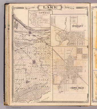
1876 Map of Lake County (with) Lowell, Hobart … State Atlas Map of Lake County. (with) Lowell ... (w … |

1876 City of Valparaiso (with) Monticello, Fr … State Atlas City of Valparaiso. (with) Monticello, W … |

1876 City of La Porte ... Michigan City, La P … State Atlas City of La Porte, La Porte Co. Michigan … |

1876 Map of Starke County (with) Knox, North … State Atlas Map of Starke County. (with) Knox ... (w … |

1876 Map of Marshall County. State Atlas Map of Marshall County. (Published by Ba … |

1876 (Portraits of) Hon. Thomas A. Hendricks … State Atlas (Portraits of) Hon. Thomas A. Hendricks … |

1876 Plan of Warsaw (with) Pierceton, Plymout … State Atlas Plan of Warsaw, Kosciusko Co., Ind. (wit … |

1876 Map of Kosciusko County. State Atlas Map of Kosciusko County. (Published by B … |