Search Results:

1861 Colorado River. Chemehuevis Valley, From … Exploration Book Colorado River. Chemehuevis Valley, From … |

1861 Yuma Shoals. Exploration Book Fig 1. - Yuma Shoals. |

1861 Explorer's Pass. Exploration Book Fig 2. - Explorer's Pass. |

1861 Purple Hills. Exploration Book Fig 3. - Purple Hills. |

1861 Cane Brake Canon, from near Camp 16. Exploration Book Cane Brake Canyon, from near Camp 16. Co … |

1861 Purple Hills Pass. Exploration Book Fig 4. - Purple Hills Pass. |

1861 Red Rock Gate. Exploration Book Fig 5. - Red Rock Gate. |

1861 Sleeper's Bend. Exploration Book Fig 6. - Sleeper's Bend. |

1861 Light-house Rock. Exploration Book Fig 7. - Light-house Rock. |

1861 Riverside Mountains. Exploration Book Fig 8. - Riverside Mountains. |

1861 Chemehuevis. Exploration Book Chemehuevis. Colorado Exploring Expediti … |

1861 Monument Mountains. Exploration Book Fig 9. - Monument Mountains. |

1861 Corner Rock. Exploration Book Fig 10. - Corner Rock. |

1861 Monument Canyon. Exploration Book Fig 11. - Monument Canyon. |

1861 Monument Range from the North. Exploration Book Fig 12. - Monument Range from the North. |

1861 Mount Whipple. Exploration Book Fig 13. - Mount Whipple. |

1861 Remains of Grand Mesa in Chemehuevis Val … Exploration Book Fig 14. - Remains of Grand Mesa in Cheme … |

1861 Mojave Canon. Exploration Book Mojave Canon. Colorado Exploring Expedit … |

1861 Mouth of Mojave Canon. Exploration Book Fig 15. - Mouth of Mojave Canon. |

1861 Colorado River. Mojave Valley, From Moja … Exploration Book Colorado River. Mojave Valley, From Moja … |

1861 Head of Mojave Canon. Exploration Book Fig 16. - Head of Mojave Canon. |

1861 Chimney Peak from the North. Exploration Book Fig 1. Chimney Peak from the North. |

1861 Spire Range. Exploration Book Fig 2. Spire Range. |

1861 The Needles (Mojave Range). Exploration Book The Needles (Mojave Range). Colorado Exp … |

1861 Section of Trough of Colorado at Elephan … Exploration Book Fig 10. Section of Trough of Colorado at … |

1876 Keith residence. County Atlas Res. of P.G. Keith, Santa Clara, Cal. (P … |

1876 Walker, Ball residences. County Atlas Residence of Robert Walker, Redwood Tp., … |

1876 Hargis, Cheney residences. County Atlas Residence of W.F. Hargis, Santa Clara, C … |

1876 Dougherty, Murphy residences. County Atlas Res. of W.P. Dougherty, San Jose, Cal. R … |

1876 St. James Hotel, residence. County Atlas Saint James Hotel, First St., San Jose, … |

1876 Ogier res., Lone-Hill Vineyard. County Atlas Res. and farm of J.H. Ogier, San Jose, C … |

1876 Businesses, residences, San Jose, Mtn. V … County Atlas Rea Block ... San Jose, Cal. Res. of Alf … |

1876 Wright, Putnam residences. County Atlas Res. of Wm. Wright, Mountain View ... Re … |

1891 Bird's eye view, Honey Lake Valley. Separate Map Bird's eye view of Honey Lake Valley. La … |

1868 View: The Yosemite Valley, from the Mari … Guide Book (View) The Yosemite Valley, from the Mar … |
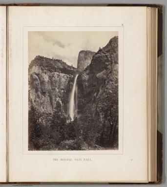
1868 View: The Bridal Veil Fall. Guide Book (View) The Bridal Veil Fall. |

1868 View: El Capitan. Guide Book (View) El Capitan. |

1868 View: El Capitan and Cathedral Rock, Vie … Guide Book (View) El Capitan and Cathedral Rock, Vi … |

1868 View: Cathedral Rock, near view from the … Guide Book (View) Cathedral Rock, near view from th … |

1868 View: Cathedral Rock and Spires. Guide Book (View) Cathedral Rock and Spires. |

1868 View: The Cathedral Spires. Guide Book (View) The Cathedral Spires. |

1868 View: The Three Borthers. Guide Book (View) The Three Borthers. |

1868 View: Sentinel Rock. Guide Book (View) Sentinel Rock. |

1868 View: The Yosemite Falls. Guide Book (View) The Yosemite Falls. |

1868 View: The Yosemite Falls, from Sentinel … Guide Book (View) The Yosemite Falls, from Sentinel … |

1868 View: The North Dome, Royal Arches and W … Guide Book (View) The North Dome, Royal Arches and … |

1868 View: The North Dome. Guide Book (View) The North Dome. |

1868 View: The Half Dome. Guide Book (View) The Half Dome. |

1868 View: View Up the Canyon of the Illiloue … Guide Book (View) View Up the Canyon of the Illilou … |

1868 View: The Vernal Fall. Guide Book (View) The Vernal Fall. |