Search Results:

1810 Mexico 3. Regional Atlas (A new map of Mexico and adjacent provin … |
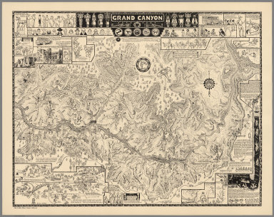
1931 Grand Canyon, 1931 Separate Map Grand Canyon. (Drawn by) Jo Mora. Copyri … |

1931 Grand Canyon Separate Map Grand Canyon. (Drawn by) Jo Mora. Copyri … |

1938 Reg Mannning's Cartoon Map of Arizona. Separate Map Reg Mannning's Cartoon Map of Arizona. |

1873 New Mexico and Arizona. World Atlas Gray's Atlas Map of New Mexico and Arizo … |

1884 Arizona and New Mexico. National Atlas Arizona and New Mexico. |

1878 Arizona. National Atlas Cram's Rail Road & Township Map of Arizo … |

1891 Map of New Mexico and Arizona. 85 World Atlas Map of New Mexico and Arizona. Copyright … |

1939 Rand McNally Road map: Arizona, New Mexi … National Atlas Rand McNally Road map: Arizona, New Mexi … |

1935 Arizona. National Atlas Arizona. |

1875 Topographical Sketch...Diversion of The … National Atlas Topographical Sketch showing the Outward … |

1877 Cover: Arizona, S. California, parts of … Pocket Map (Covers to) New Map Of The Territory Of … |

1877 New Map Of The Territory Of Arizona, Sou … Pocket Map New Map Of The Territory Of Arizona, Sou … |

1882 Cover: Tertiary history, Grand Canon Dis … Geologic Atlas (Covers to) Department Of The Interior, … |

1882 Title Page: Tertiary history of the Gran … Geologic Atlas (Title Page to) Department Of The Interi … |

1882 Index: Tertiary history, Grand Canon Dis … Geologic Atlas (Index to) Department Of The Interior, U … |

1882 Geological Map Of The Western Part Of Th … Geologic Atlas Geological Map Of The Western Part Of Th … |

1882 Sketch Map ... showing The Faults of the … Geologic Atlas Sketch Map of the Western Part of the Pl … |

1882 Looking up the Toroweap from Vulcan's Th … Geologic Atlas Looking up the Toroweap from Vulcan's Th … |

1882 Grand Canon, foot of the Toroweap lookin … Geologic Atlas The Grand Canon at the foot of the Torow … |

1882 Map Of The Uinkaret Plateau. North Half. … Geologic Atlas Map Of The Uinkaret Plateau. North Half. … |

1882 Map Of The Uinkaret Plateau. South Half. Geologic Atlas Map Of The Uinkaret Plateau. South Half. … |

1882 Composite: Uinkaret Plateau. N. & S. hal … Geologic Atlas (Composite) Map Of The Uinkaret Plateau. … |

1882 Views looking east and south from Mt. Tr … Geologic Atlas Views looking east and south from Mt. Tr … |

1882 Views from Mt. Trumbull and Mt. Emma. Geologic Atlas Views from Mt. Trumbull and Mt. Emma. W( … |

1882 Geologic Map Of The Southern Part Of The … Geologic Atlas Geologic Map Of The Southern Part Of The … |

1882 Geologic Map Of The Southern Part Of The … Geologic Atlas Geologic Map Of The Southern Part Of The … |

1882 Geologic Map Of The Southern Part Of The … Geologic Atlas Geologic Map Of The Southern Part Of The … |

1882 Geologic Map Of The Southern Part Of The … Geologic Atlas Geologic Map Of The Southern Part Of The … |

1882 Composite: Geologic map, S. pt. Kaibab P … Geologic Atlas (Composite) Geologic Map Of The Southern … |

1882 Panorama from Point Sublime. [Part I. Lo … Geologic Atlas Panorama from Point Sublime. [Part I. Lo … |

1882 Panorama from Point Sublime. [Part II. L … Geologic Atlas Panorama from Point Sublime. [Part II. L … |

1882 Panorama from Point Sublime. [Part III. … Geologic Atlas Panorama from Point Sublime. [Part III. … |

1882 Composite: Panorama from Pt. Sublime. I- … Geologic Atlas (Composite) Panorama From Point Sublime. … |

1882 The Transept, Kaibab Division, Grand Can … Geologic Atlas The Transept, Kaibab Division, Grand Can … |

1882 Views of the Marble Canon Platform from … Geologic Atlas Views of the Marble Canon Platform from … |

1882 Geologic Map Of The Mesozoic Terraces Of … Geologic Atlas Geologic Map Of The Mesozoic Terraces Of … |

1882 Geologic Map Showing The Kanab, Paria An … Geologic Atlas Geologic Map Showing The Kanab, Paria An … |

1882 Geologic Map Of The Colorado Plateau And … Geologic Atlas Geologic Map Of The Colorado Plateau And … |

1882 Composite: Geologic map sheets XX-XXIII. Geologic Atlas (Composite) Geologic Map Sheets XX-XXIII … |

1889 Territory of Arizona, Nebraska, Nevada, … National Atlas Territory of Arizona, Nebraska, Nevada, … |

1873 Bancroft's Map Of California, Nevada, Ut … Wall Map Bancroft's Map Of California, Nevada, Ut … |

1864 Cover: California, Nevada, Utah, Arizona … Pocket Map (Covers to) Bancroft's Map Of California … |

1864 Bancroft's Map Of California, Nevada, Ut … Pocket Map Bancroft's Map Of California, Nevada, Ut … |

1858 Map No. 1 of the El Paso & Fort Yuma Wag … Exploration Book Map No. 1 of the El Paso & Fort Yuma Wag … |

1858 Map No. 2 of the El Paso & Fort Yuma Wag … Exploration Book Map No. 2 of the El Paso & Fort Yuma Wag … |

1897 Arizona. World Atlas Rand, McNally & Co.'s new business atlas … |

1967 209-210. United States of America, West. … World Atlas 209-210. United States of America, West. … |

1876 75. Cent., W. Arizona. National Atlas Parts Of Central & Western Arizona - Atl … |

1865 California, Nevada, Utah, Colorado, Ariz … World Atlas Colton's Map of California, Nevada, Utah … |