Who What Where WhenREMOVE |
REFINE
Search Results:
1-11 of 11
Author
Emory, William H.
Full Title
(Title Page to) Notes of a Military Reconnoissance, From Fort Leavenworth, In Missouri, To San Diego, In California, Including Part of the Arkansas, Del Norte, and Gila Rivers. By W.H. Emory, Brevet Major, Corps Topographical Engineers. Made in 1846-7, with the Advanced Guard of the "Army of the West." Washington: Wendell and van Benthuysen, Printers. 1848. [Senate] 30th Congress, 1st Session. Executive, No. 7.
Publisher
Wendell and Van Benthuysen
Author
Emory, William H.
Full Title
Military Reconnaissance Of The Arkansas Rio Del Norte And Rio Gila By W.H. Emory, Lieut. Top. Engrs. Assisted ... by J.W. Abert and W.G. Peck, and ... by W.H. Warner and Mr. Norman Bestor, Made in 1846-7, with the advance guard of the "Army of the West". Under Command Of Brig. Gen. Stephn. W. Kearny. Constructed under the orders of Col. J.J. Abert ... 1847. Drawn by Joseph Welch. Engraved on stone by E. Weber & Co. Baltimore.
Publisher
Wendell and Van Benthuysen
Author
Fremont, J.C.
Full Title
(Title Page to) Geographical Memoir upon Upper California In Illustration of His Map of Oregon and California, by John Charles Fremont: Addressed to the Senate of the United States. Washington: Wendell and Van Benthuysen, Printers. 1848. [Senate.] 30th Congress, 1st Session. Miscellaneous. No. 148.
Publisher
Wendell and Van Benthuysen
Author
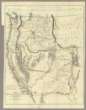
Fremont, J.C.
Full Title
Map Of Oregon And Upper California From the Surveys of John Charles Fremont And other Authorities. Drawn By Charles Preuss Under the Order of the Senate Of The United States, Washington City 1848. Lithy. by E. Weber & Co. Balto. (inset) Profile of the travelling route from the South Pass of the Rocky Mountains to the Bay of San Francisco.
Publisher
Wendell and Van Benthuysen
Author
Ord, Edward Otho Cresap (E.O.C.O.)
Full Title
Topographical Sketch of the Gold & Quicksilver District Of California, July 25th 1848. E. O. C. O. Lt. U.S.A. P.S. Duval's Lith. steam Press Phila.
Publisher
U.S.
Author
Mason, Richard B.
Full Title
Positions of the Upper and Lower Gold Mines on the South Fork of the American River, California. July 20th, 1848. (with, on one sheet) Upper Mines. Nos. 1&8. Lower Mines or Mormon Diggings. No. 3.
Publisher
U.S.
Author
Mason, Richard B.
Full Title
Upper Mines. Nos. 1&8. Lower Mines or Mormon Diggings. No. 3. (with, on one sheet) Positions of the Upper and Lower Gold Mines on the South Fork of the American River, California. July 20th, 1848.
Publisher
U.S.
Author
Ensigns & Thayer
Full Title
Ornamental Map Of The United States & Mexico. Map Of The United States And Mexico Including Oregon, Texas and the Californias. Entered ... 1848, by Ensigns & Thayer ... New York. Published by Ensign & Thayer, 50 Ann Street New York. And 12 Exchange St., Buffalo. Sowle & Ward, 43 Cornhill, Boston. Rufus Blanchard: Cincinatti.
Publisher
[Ensigns & Thayer ; Rufus Blanchard, Sowle & Ward]
Author
[Bourquin, Frederick, Mitchell, Samuel Augustus, Tanner, Henry S.]
Full Title
Oregon, Upper California & New Mexico. Published by S. Augustus Mitchell, N.E. Corner of Market & 7th. Streets Philadelphia. 1849. Entered according to Act of Congress in the 1845 by H.N. Burroughs - in the Clerk's Office of the Eastern District of Penna. 36.
Publisher
S. Augustus Mitchell.
Author
[Bidwell, John, 1819-1900, Larkin, Thomas Oliver, 1802-1858]
Full Title
Map of the Valley of the Sacramento including the Gold Region. This map is a correct tracing of the map of Bidwell, Land Surveyor, by Thos. O. Larkin Esq: late Consul of the U.S. for California; and by him stated to be the best reference in California. Entered according to act of Congress in the year 1848 by J.H. Bufford & Co. in the Clerks office for the District Court of Massachusetts. Table of Distances (distances by sea to California and points in between)
Publisher
J.H. Bufford & Co.
Author
Mitchell, Samuel Augustus
Full Title
Oregon and Upper California. Published by S. Augustus Mitchell, N.E. corner of Market & Seventh Streets. Philadelphia. 1848. Entered according to Act of Congress in the year 1845 by H.N. Burroughs in the ... District Court of the eastern district of Pennsylvania.
Publisher
S.A. Mitchell
1-11 of 11
|