Search Results:

1764 Plan de l'Isle d'Elbe Chart Atlas Plan de l'Isle d'Elbe. |

1764 Plan de Port Ferrare dans l'Isle d'Elbe Chart Atlas Plan de Port Ferrare dans l'Isle d'Elbe. |

1764 Plan de Porto Longon Chart Atlas Plan de Porto Longon. |

1764 Plan du Golphe, Ville et Environs de Nap … Chart Atlas Plan du Golphe, Ville et Environs de Nap … |

1764 Plan de Baye et Poussole Chart Atlas Plan de Baye et Poussole. |

1764 Plan de la ville et baye de Gayette Chart Atlas Plan de la Baye de Gayette. |

1764 Plan de la Baye de Tarante Chart Atlas Plan de la Baye de Tarante. |

1764 Carte du Royaume de Naples Chart Atlas Carte du Royaume de Naples. |

1764 Plan De La Baye De Calvi dans l'Isle de … Chart Atlas Plan De La Baye De Calvi dans l'Isle de … |

1764 Plan de la Ville de Corte dans l'Isle de … Chart Atlas Plan de la Ville de Corte dans l'Isle de … |

1764 Golphe de Campo-Moro et Valinco Chart Atlas Golphe de Campo-Moro et Valinco. |

1764 Plan de Porto Vecchio. Chart Atlas Plan de Porto Vecchio. |

1764 Plan du Port et Ville de Boniface dans l … Chart Atlas Plan du Port et Ville de Boniface dans l … |

1764 l'Isle de Sardaigne Chart Atlas l'Isle de Sardaigne. |

1764 Isle de Sicile Chart Atlas Isle de Sicile. |

1764 Carte de l'Entree du Phare de Messine Chart Atlas Carte de l'Entree du Phare de Messine. |

1995 Europe -- Political Wall Map Die Staaten Europas. |

1825 Europe World Atlas Europe. London, Published Jany. 4.1825 b … |

1825 England World Atlas England. London, Published Jany. 4.1825 … |
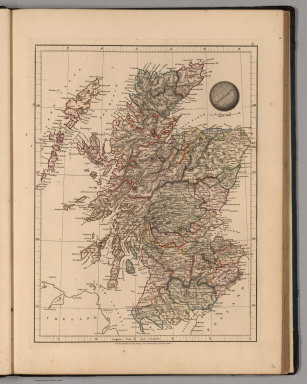
1825 Scotland World Atlas Scotland. London, Published Jany. 4.1825 … |

1825 Ireland World Atlas Ireland. London, Published Jany. 4.1825 … |

1825 Sweden and Norway World Atlas Sweden and Norway. London, Published Jan … |

1825 Russia in Europe World Atlas Russia in Europe. London, Published Jany … |

1825 Denmark World Atlas Denmark. London, Published Jany. 4.1825 … |

1825 Holland World Atlas Holland. London, Published Jany. 4.1825 … |

1825 Kingdom of the Netherlands World Atlas Kingdom of the Netherlands. London, Publ … |

1825 France and Belgium World Atlas France and Belgium. London, Published Ja … |

1825 Spain and Portugal World Atlas Spain and Portugal. London, Published Ja … |

1825 Switzerland World Atlas Switzerland. London, Published Jany. 4.1 … |

1825 Germany World Atlas Germany. London, Published Jany. 4.1825 … |

1825 Northern Italy World Atlas N. Italy. London, Published Jany. 4.1825 … |

1825 Southern Italy World Atlas S. Italy. London, Published Jany. 4.1825 … |

1825 Turkey in Europe World Atlas Turkey in Europe. London, Published Jany … |

1825 Greece World Atlas Greece. London, Published Jany. 4.1825 b … |

2001 Europe -- Physical Wall Map Europe. |

1998 Africa -- Physical Wall Map Africa. |

1996 Africa -- Physical-Political Wall Map Africa. |

1998 Africa -- Political Wall Map Africa. |

1998 Africa -- Physical Wall Map Africa. |

1950 Eurasia -- Physical Wall Map Asien. |

1796 Composite: Map of Europe. Case Map (Composite map of) Map of Europe Drawn f … |

1796 Sheet 1: Map of Europe. Case Map (Sheet 1 of) Map of Europe Drawn from al … |

1796 Sheet 2: Map of Europe. Case Map (Sheet 2 of) Map of Europe Drawn from al … |

1796 Sheet 3: Map of Europe. Case Map (Sheet 3 of) Map of Europe Drawn from al … |

1796 Sheet 4: Map of Europe. Case Map (Sheet 4 of) Map of Europe Drawn from al … |

1906 Chart of the World Shows the Forms and D … World Atlas Chart of the World Shows the Forms and D … |

1906 Mountains, Table Lands, Plains & Valleys … World Atlas The Mountains, Table Lands, Plains & Val … |

1762 Europa World Atlas Europa (engraved by) Tobias Lobeck. Tob. … |

1823 Europe. World Atlas Europe. Engraved & Published by Tanner, … |

1849 Europe World Atlas Europe. |