Search Results:

1907 Europe and Near East - General Commercia … Statistical Atlas Europe & Near East - General Commercial … |

1907 Europe - Industrial. Statistical Atlas Europe - Industrial. |

1907 Central Europe, Industrial. Statistical Atlas Central Europe, Industrial. |

1875 Composite: Sud-West Deutschland, Schweiz … World Atlas (Composite of) Sud-West Deutschland Und … |

1852 Mountains, Table Lakes, Plains & Valleys … Physical Atlas The Mountains, Table Lakes, Plains & Val … |

1808 Europe. World Atlas Europe. |

1817 Europe. World Atlas Europe. |

1808 Europe. World Atlas Europe. |

1802 Europe. World Atlas Europe. |

1822 Patriarchatus Occidentalis. World Atlas Patriarchatus Occidentalis. |

1814 Terra Veteribus Nota. World Atlas Terra Veteribus Nota. |

1821 Imperiorum Antiquorum. World Atlas Imperiorum Antiquorum. |

1818 Romanum Imperium. World Atlas Romanum Imperium. |

1801 The Empire of Charlemagne, A.D. D,CCC (8 … World Atlas The Empire of Charlemagne, A.D. D,CCC (8 … |
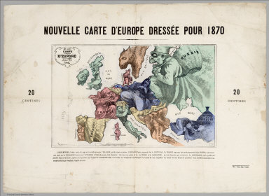
1870 Carte drolatique d'Europe pour 1870 Separate Map Carte drolatique d'Europe pour 1870 ; dr … |

1875 Europa. World Atlas Europa Im Maassstabe von 1:15.000.000. V … |

1811 Europe. World Atlas Europe. London, Published by S.A. Oddy, … |

1883 Europe. World Atlas Europe. |

1883 Europe in the Time of Napoleon I. Sweden … World Atlas Europe in the Time of Napoleon I. Sweden … |

1944 Map I, The Russian Front Separate Map [World War II battlefronts]. Map I, The … |

1944 Map II, The Balkans Separate Map [World War II battlefronts]. Map II, The … |

1944 Map III, Italy & South France Separate Map [World War II battlefronts]. Map III, It … |

1944 Map IV. The Western Front Separate Map [World War II battlefronts]. Map IV. The … |

1825 Europe. World Atlas Europe. American Atlas. Published by H.S … |

1944 Europe as Viewed from the U.S.S.R. Separate Map Europe as Viewed from the U.S.S.R. Newsm … |

1944 Vicinity of Florence, Italy. Guam, Agigu … Separate Map Newsmap. (War front near Florence, Italy … |

1943 Target Berlin. Separate Map Target Berlin. Newsmap. Monday, October … |

1943 Japan from Siberia. Separate Map Japan from Siberia. Newsmap. Monday, May … |

1945 Newsmap. Monday, May 7, 1945. ... Vol. I … Separate Map Newsmap. Monday, May 7, 1945. ... Vol. I … |

1854 133. Carte pour servir a l'histoire de l … World Atlas 133. Carte pour servir a l'histoire de l … |

1854 135. Carte de l'Empire Grec en 1025. 136 … World Atlas 135. Carte de l'Empire Grec en 1025 a la … |

1872 L'Europe en ce moment - fantaisie politi … Separate Map Europe "L'Europe en ce moment - fantaisi … |

1838 Map of cities of Europe World Atlas (Map of cities of Europe). (to accompany … |

1838 Southern Europe World Atlas Southern Europe. (to accompany) A Compre … |

1838 Europe World Atlas Europe. (to accompany) A Comprehensive A … |

1843 Europe. World Atlas Europa I (Europe). |

1843 Europe. World Atlas Europa (II) (Europe). |

1935 Europe World Atlas Europe. Copyright, J.W. Clement Co. Matt … |

1810 Covers: Map Exhibiting the Great Post Ro … Case Map (Covers to) Map Exhibiting the Great Pos … |

1810 (Northwest Section) Map Exhibiting the G … Case Map (Northwest Section) Map Exhibiting the G … |

1810 (Northeast Section) Map Exhibiting the G … Case Map (Northeast Section) Map Exhibiting the G … |
1810 (Southwest Section) Map Exhibiting the G … Case Map (Southwest Section) Map Exhibiting the G … |

1810 (Southeast Section) Map Exhibiting the G … Case Map (Southeast Section) Map Exhibiting the G … |

1810 Composite Map: Map Exhibiting the Great … Case Map (Composite Map) Map Exhibiting the Great … |

1873 Europe. World Atlas Gray's Atlas Map of Europe. |

1844 No. 5: Map of the travels of the Apostle … Religious Atlas No. 5: Map of the travels of the Apostle … |

1877 Europe. National Atlas Gray's New Map of Europe by Frank A. Gra … |

1886 Europe : pour L'Invasiom des Barbares World Atlas Europe : pour L'Invasiom des Barbares. P … |

1886 Europe Feodale. France Feodale World Atlas Europe Feodale ; pendant le Xe. et XIe. … |

1886 Europe : a L"Europe des croisades World Atlas Europe : a L"Europe des croisades. Par M … |