Search Results:

1904 Covers: Sheet 11. National Atlas (Covers to) Sheet 11. |

1904 Sheet 11. National Atlas Sheet 11. |

1904 Covers: Sheet 12. National Atlas (Covers to) Sheet 12. |

1904 Sheet 12. National Atlas Sheet 12. |

1904 Covers: Sheet 13. National Atlas (Covers to) Sheet 13. |

1904 Sheet 13. National Atlas Sheet 13. |

1904 Covers: Sheet 14 National Atlas (Covers to) Sheet 14. |

1904 Sheet 14. National Atlas Sheet 14. |

1904 Covers: Sheet 15. National Atlas (Covers to) Sheet 15. |

1904 Sheet 15. National Atlas Sheet 15. |

1904 Covers: Sheet 16 National Atlas (Covers to) Sheet 16. |

1904 Sheet 16. National Atlas Sheet 16. |
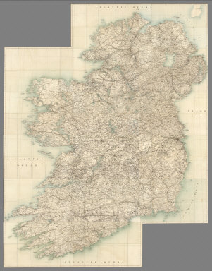
1904 Composite: Sheets 1-16. National Atlas (Composite) Sheets 1-16. |

1798 Ireland. World Atlas A map of Ireland divided into provinces … |

1865 Die Britischen Inseln und das Umliegende … World Atlas Stieler's Hand-Atlas ... No. 15a. Die Br … |

1866 Ireland. World Atlas Stieler's Hand-Atlas ... No. 15d. Irelan … |

1825 England, Schottland und Ireland World Atlas England, Schottland und Ireland; entw. u … |

1824 Ireland World Atlas Jreland: nach A. St's Angabe, entw. U. g … |

1823 Die Britischen Inseln World Atlas Die Britischen Jnseln England, Schotland … |

1824 Composite: England, Schotland, Ireland World Atlas (Composite of) England, Schotland, Irela … |

1807 I: Untitled outline map of Ireland School Atlas I: (Untitled outline map of Ireland). |

1880 Ireland. World Atlas Stieler's Hand-Atlas No. 48. Ireland. (i … |

1880 Composite:Grossbritannien, Ireland. World Atlas (Composite of) Stieler's Hand-Atlas No. … |

1875 Die Britischen Inseln Und Das Umliegende … World Atlas Die Britischen Inseln Und Das Umliegende … |

1875 Ireland. World Atlas Ireland Im Maassstabe Von 1:1.500.000. V … |

1811 Ireland. World Atlas A Map of Ireland According to the best A … |

1850 Die Brittischen Inseln und Die Nord-See. … World Atlas No. XVII. Stieler's Hand-Atlas (No. 15a. … |

1850 Ireland. World Atlas No. XX. Stieler's Hand-Atlas (No. 15d.) … |

1822 Ireland School Atlas Ireland. (to accompany) The Juvenile Atl … |

1907 British Isles, Comparative Value of Land … Statistical Atlas British Isles, Comparative Value of Land … |

1907 British Isles - Industrial. Agricultural … Statistical Atlas British Isles - Industrial. Agricultural … |

1852 The Mountains, Table Lands, Plains & Val … Physical Atlas The Mountains, Table Lands, Plains & Val … |

1808 Ireland. World Atlas Ireland. |

1817 United Kingdoms of Great Britain and Ire … World Atlas United Kingdoms of Great Britain and Ire … |

1817 Ireland. World Atlas Ireland. |

1808 Britain, or the United Kingdom of Englan … World Atlas Britain, or the United Kingdom of Englan … |

1808 Ireland. World Atlas Ireland as Represented in the Imperial P … |

1794 A New Map of Great Britain and Ireland. World Atlas A New Map of Great Britain and Ireland. |

1806 Ireland. World Atlas Ireland as Represented in the Imperial P … |

1823 Die Brittischen Inseln. (British Isles). World Atlas No. XVII. Stielers Hand-Atlas (No. 15). … |

1852 Composite: England und Wales, Schotland, … World Atlas (Composite of) No. XVII, XIX, XX. Stiele … |

1881 Ireland to Illustrate the Religious Cond … Statistical Atlas Ireland to Illustrate the Religious Cond … |

1881 Ireland to Illustrate the Educational Co … Statistical Atlas Ireland to Illustrate the Educational Co … |

1881 Ireland to Illustrate the Industrial Con … Statistical Atlas Ireland to Illustrate the Industrial Con … |

1881 Ireland to Illustrate the Criminal Condi … Statistical Atlas Ireland to Illustrate the Criminal Condi … |

1881 Ireland to Illustrate the Pauperism of t … Statistical Atlas Ireland to Illustrate the Pauperism of t … |

1881 Ireland to Illustrate the Marine Commerc … Statistical Atlas Ireland to Illustrate the Marine Commerc … |

1881 Ireland to Illustrate the Agricultural C … Statistical Atlas Ireland to Illustrate the Agricultural C … |

1881 Ireland to Illustrate the Military Condi … Statistical Atlas Ireland to Illustrate the Military Condi … |

1881 Ireland to Illustrate the Legal Conditio … Statistical Atlas Ireland to Illustrate the Legal Conditio … |