Search Results:

1870 Mexico, Central America, West Indies. [State Atlas, World Atlas] Map of Mexico, Central America, and the … |

1840 United States Of Mexico. World Atlas The United States Of Mexico. (with) Guat … |

1835 Mexico, Guatamala. World Atlas Mexico & Guatamala (sic). Fenner Sc., Pa … |

1884 Railway, steamship lines Southern Pacifi … Timetable Map Correct map of the railway & steamship l … |

1884 Cover: "Sunset Route" Timetable Map (Covers to) "Sunset Route" The Southern … |

1884 Text Page: "Sunset Route" Timetable Map (Text Page to) "Sunset Route" The Southe … |

1886 Missouri Pacific Railway. Timetable Map Map of the South West Railway System. Mi … |

1893 Chicago Milwaukee and St. Paul Ry. and c … Timetable Map Map of the Chicago-Milwaukee & St. Paul … |

1893 Cover: Chicago Milwaukee and St. Paul Ra … Timetable Map (Covers to) Chicago Milwaukee and St. Pa … |

1893 Text Page: Chicago Milwaukee and St. Pau … Timetable Map (Text Page to) Chicago Milwaukee and St. … |

1758 Mexico Or New Spain World Atlas Mexico Or New Spain. (to accompany) Atla … |

1890 United States and territories. Wall Map Map of the United States and territories … |

1905 Vereinigte Staaten von Nordamerika World Atlas Vereinigte Staaten von Nordamerika. Okt. … |

1905 Sudwestliche Vereinigte Staaten und Nord … World Atlas Sudwestliche Vereinigte Staaten und Nord … |

1859 Map of the Republic of Mexico. World Atlas Map of the Republic of Mexico Compiled b … |

1864 Text Page: (Continues) Introduction Exploration Book (Text Page to) Introduction. (to accompa … |

1864 Valley and City of Mexico Exploration Book Valley and City of Mexico. Lith. of Majo … |

1864 Popocatepetl. Iztaccihuatl Exploration Book Popocatepetl. Iztaccihuatl. Lith. of Maj … |

1864 Geological map and profiles of some of t … Exploration Book Geological map and profiles of some of t … |
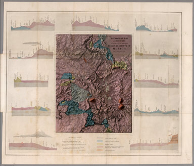
1864 Geological map and profiles of some of t … Exploration Book Geological map and profiles of some of t … |

1943 Mexico World Atlas Mexico. Copyright, J.W. Clement Co., Mat … |

1875 Verein-Staaten Von Nord-America, Mexico, … World Atlas Verein-Staaten Von Nord-America, Mexico, … |

1940 Road map of Mexico National Atlas Rand McNally Road map, Mexico. Copyright … |

1855 Mexico, Texas, Californien, C. America. World Atlas Mexico, Texas und Californien. (with) Di … |

1846 Covers: Mexico and Yucatan Guide Book (Covers to) Description Of The Republic … |

1846 Title Page: Description Of The Republic … Guide Book (Title Page to) Description Of The Repub … |

1846 Contents: Table of contents.Description … Guide Book (Contents to) Table of contents. (to acc … |

1846 Contents: (Continues) Table of contents. … Guide Book (Contents to) Table of contents. (to acc … |

1846 Composite Text: Description Of The Repub … Guide Book (Composite Text to) Description Of The R … |

1846 Map of Mexico including Yucatan Guide Book Map of Mexico including Yucatan. Entered … |

1828 Mexico und Centro-America, 1828 World Atlas Mexico und Centro-America. Nach den best … |

1879 West-Indien in 4 Blattern, Bl. 3 (West I … World Atlas Stieler's Hand-Atlas No. 81. West-Indien … |

1892 Post Route Map of the State of Texas Wall Map Post Route Map of the State of Texas wit … |

1915 Covers: Explorations on the northern fro … Separate Map (Covers to) Explorations on the Northern … |

1915 Explorations on the northern frontier of … Separate Map Explorations on the northern frontier of … |

1885 Map Atlantic Coast Line. Timetable Map Map of the Atlantic Coast Line of railwa … |

1885 Cover: Atlantic Coast Line. Timetable Map (Covers to) The Atlantic Coast Line nort … |

1817 Spanish Dominions in North America. World Atlas Spanish Dominions in North America. |

1885 Map of Mexico National Atlas Map of Mexico. (to accompany) Bradstreet … |

1972 Bahia de Compeche. Geologic Atlas Bahia de Compeche. |

1971 Schematic Block Diagram of the Head of t … Geologic Atlas Schematic Block Diagram of the Head of t … |

1885 Text Page: Atlantic Coast Line. Timetable Map (Text Page to) The Atlantic Coast Line n … |

1903 Route of the California Limited. Timetable Map Route of the California Limited -- "Sant … |

1903 Cover: California Limited. Timetable Map (Covers to) The California Limited. Pict … |

1903 Title Page: California Limited. Timetable Map (Title Page) The California Limited. Pic … |

1904 Santa Fe. Timetable Map Santa Fe. Poole Bros., Chicago. |

1904 Cover: AT&SF Railway, connecting lines. Timetable Map (Covers to) Santa Fe. The Atchison, Tope … |

1844 Cover Vol 1: Exploration du Territoire d … Exploration Book (Covers to Vol 1) Exploration Du Territo … |

1844 Title Page Vol 1: Exploration du Territo … Exploration Book (Title Page to Vol 1) Exploration Du Ter … |

1844 Vue du Port De Monterey Capitale de la N … Exploration Book Vue du Port De Monterey Capitale de la N … |