Search Results:

1885 Frontier, Gosper, Red Willow, Furnas Cos … State Atlas Frontier, Gosper, Red Willow and Furnas … |

1885 Cuming County. State Atlas Cuming County. (Philadelphia, Everts & K … |

1885 West-Point, Wisner. State Atlas West-Point, Cuming Co. (with) Wisner, Cu … |

1885 York Co. State Atlas York Co. (Philadelphia, Everts & Kirk, 1 … |

1890 Kansas, Nebraska. World Atlas County & township map of the states of K … |

1870 Kan., Neb., Colo. [State Atlas, World Atlas] Map of Kansas, Nebraska and Colorado. Sh … |

1880 Kansas, Nebraska. World Atlas County & township map of the states of K … |

1966 Eolian Activity. Transverse and Paraboli … Physical Atlas Eolian Activity. Transverse and Paraboli … |

1859 A New Map of Kansas. World Atlas A New Map of Kansas by W.H. Holmes. Publ … |

1859 Nebraska, Kansas, New Mexico, and Indian … World Atlas A New Map of Nebraska, Kansas, New Mexic … |

1875 Vereinigte Staaten Von Nord-Amerika In 6 … World Atlas Vereinigte Staaten Von Nord-Amerika In 6 … |

1940 Road map of Nebraska National Atlas Rand McNally Road map, Nebraska. Copyrig … |

1873 Vereinigte Staaten von Nord-Amerika in 6 … World Atlas Stieler's Hand-Atlas ... No. 82. Peterma … |

1890 (Birdseye view Great Plains) Timetable Map (Birdseye view of the Great Plains). Kni … |

1890 Cover: World's pictorial line. Timetable Map (Covers to) World's pictorial line. Bird … |

1890 Text Page: World's pictorial line. Timetable Map (Text Page to) World's pictorial line. B … |

1851 Iowa, Illinois, Nebraska, Missouri, West … National Atlas Atlas de Vereenigde Staten No. 9. Iowa, … |

1885 Nebraska National Atlas Nebraska. (to accompany) Bradstreet's Po … |

1920 Nebraska highway map. Pocket Map Highway map and guide of Nebraska. Copyr … |

1920 Cover: Nebraska highway map. Pocket Map (Covers to) Highway map and guide of Neb … |

1920 Text Page: Nebraska highway map. Pocket Map (Text Page to) Highway map and guide of … |

1935 Nebraska. National Atlas Nebraska. |

1904 Nebraska. County Atlas Nebraska. |

1939 Salt Lake - Denver - Cheyenne. Denver - … [Ephemera, Pamphlet] Salt Lake - Denver - Cheyenne. Denver - … |

1939 North Platte - Omaha. Omaha - Iowa City. [Ephemera, Pamphlet] North Platte - Omaha. Omaha - Iowa City. |

1883 Nebraska. World Atlas Nebraska. |

1939 Nebraska, the Cornhusker State Separate Map Nebraska, the Cornhusker State. The Ment … |

1873 Nebraska. World Atlas Gray's Atlas Nebraska. |

1877 Nebraska. National Atlas Nebraska. Copyright 1877 by O.W. Gray & … |

1878 Nebraska. National Atlas Cram's Rail Road & Township Map of Nebra … |

1891 Map of Nebraska. 82 World Atlas Map of Nebraska. Copyright 1891 by Matth … |

1939 Rand McNally Road map: Nebraska National Atlas Rand McNally Road map: Nebraska. Copyrig … |

1891 (Nebraska, Colorado) Railroad Map of the … Case Map Rand, McNally & Co.'s New Shippers' Rail … |

1891 Covers: (Nebraska, Colorado) Railroad Ma … Case Map (Covers to) Rand, McNally & Co.'s New Sh … |

1889 Territory of Arizona, Nebraska, Nevada, … National Atlas Territory of Arizona, Nebraska, Nevada, … |

1859 Map of the Fort Ridgely & South Pass Roa … Exploration Book Map of the Fort Ridgely & South Pass Roa … |
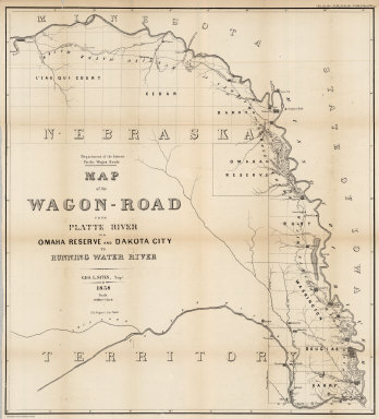
1858 Map of the Wagon-Road from Platte River … Exploration Book Map of the Wagon-Road from Platte River … |

1865 Kansas, and Nebraska and Indian Territor … World Atlas Colton's Map of Kansas, Nebraska, Dakota … |

1869 Nebraska. World Atlas Colton's Nebraska. Published By G. W & C … |

1852 Nebraska, Kansas, Iowa, Missouri. National Atlas (Nebraska, Kansas, Iowa, Missouri). |

1948 Nebraska. Oklahoma. World Atlas Nebraska. 1366. Oklahoma. 5357. |

1865 Iowa And Nebraska. World Atlas Johnson's Iowa And Nebraska Published By … |

1865 Nebraska, Dakota, Idaho, and Montana. World Atlas Johnson's Nebraska, Dakota, Idaho, and M … |

1931 Soil Map of the United States, Section 6 … National Atlas Soil Map of the United States by Curtis … |

1874 Indian Territory (Oklahoma). Nebraska. World Atlas Gray's Atlas Map of Indian Territory (Ok … |

1924 Text Page: Industrial Statistics of the … National Atlas (Text Page) Industrial Statistics of the … |

1924 AutoTrails Map, Iowa, Eastern Nebraska, … National Atlas Commercial Atlas of America. Rand McNall … |

1924 Text Page: Nebraska - Geographical Featu … National Atlas (Text Page) Nebraska - Counties, Creeks, … |

1924 Nebraska. National Atlas Commercial Atlas of America. Rand McNall … |

1924 Text Page: Nebraska - Geographical Featu … National Atlas (Text Page) Nebraska - Counties, Creeks, … |