Search Results:

1872 Toledo, Lucas Co. State Atlas Toledo, Lucas Co. by J.B. Marston, C.E., … |
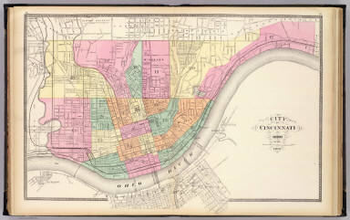
1872 City of Cincinnati, Ohio. State Atlas City of Cincinnati, Ohio. 1872. (Publish … |

1872 Dayton. State Atlas Dayton. (Published by Stedman, Brown & L … |

1872 Springfield, Clarke Co. State Atlas Springfield, Clarke Co. by J. Douglass M … |

1872 Cuyahoga, Erie, Huron, Lorain, Medina, O … State Atlas Topographical atlas of Ohio. Cuyahoga, E … |

1872 Ashtabula, Geauga, Lake, Mahoning, Porta … State Atlas Topographical atlas of Ohio. Ashtabula, … |

1872 Carroll, Columbiana, Harrison, Jefferson … State Atlas Topographical atlas of Ohio. Carroll, Co … |

1872 Athens, Belmont, Fairfield, Guernsey, Ho … State Atlas Topographical atlas of Ohio. Athens, Bel … |

1872 Gallia, Jackson, Lawrence, Meigs, and Vi … State Atlas Topographical atlas of Ohio. Gallia, Jac … |

1872 Adams, Brown, Highland, Pike, and Scioto … State Atlas Topographical atlas of Ohio. Adams, Brow … |

1872 Auglaize, Champaign, Clarke, Darke, Dela … State Atlas Topographical atlas of Ohio. Auglaize, C … |

1872 Clinton, Fayette, Greene, Pickaway, and … State Atlas Topographical atlas of Ohio. Clinton, Fa … |

1872 Butler, Clermont, Hamilton, Montgomery, … State Atlas Topographical atlas of Ohio. Butler, Cle … |

1872 Allen, Crawford, Defiance, Fulton, Hanco … State Atlas Topographical atlas of Ohio. Allen, Craw … |

1872 Ashland, Coshocton, Holmes, Knox, Richla … State Atlas Topographical atlas of Ohio. Ashland, Co … |

1906 Illinois, Indiana, Ohio, Kentucky. World Atlas Illinois, Indiana, Ohio, Kentucky. |

1823 Ohio and Indiana. World Atlas Ohio and Indiana By H.S. Tanner. Engrave … |

1859 Covers: Ohio Pocket Map (Covers to) Colton's Railroad & Township … |

1859 Ohio Pocket Map Colton's Railroad & Township Map of the … |

1886 J.T. Barker's, Rail Road and Township, M … County Atlas J.T. Barker's, Rail Road and Township, M … |

1849 New Map of Ohio with its Canals, Roads & … World Atlas A New Map of Ohio with its Canals, Roads … |

1874 Ohio. County Atlas New Map of Ohio Prepared Especially for … |

1865 County map of Ohio and Indiana World Atlas County map of Ohio and Indiana. Drawn & … |

1865 Plan of Cincinnati and Vicinity World Atlas Plan of Cincinnati and Vicinity. Entered … |

1853 Covers: Ohio Pocket Map (Covers to) Colton's Railroad & Township … |

1853 Ohio Pocket Map Colton's Railroad & Township Map of the … |

1865 Covers: Oil District Of West Virginia An … Pocket Map (Covers to) Colton's Map Of The Oil Dist … |

1865 Oil District Of West Virginia And Ohio Pocket Map Colton's Map Of The Oil District Of West … |

1875 Covers: Ohio Pocket Map (Covers to) New Map Of Ohio. Published B … |

1875 Ohio Pocket Map (Covers to) New Map Of Ohio. Published B … |

1864 Covers: Ohio Pocket Map (Covers to) Colton's Railroad & Township … |

1864 Ohio Pocket Map Colton's Railroad & Township Map of the … |

1890 Covers: Railroad Map Of Ohio Pocket Map (Covers to) Railroad Map Of Ohio. Publis … |

1890 Railroad Map Of Ohio Pocket Map Railroad Map Of Ohio. Published By The S … |

1853 Covers: Railroad & Township Map Of Ohio Pocket Map (Covers to) Railroad & Township Map Of O … |

1853 Railroad & Township Map Of Ohio Pocket Map Railroad & Township Map Of Ohio. Publish … |

1874 County map of Ohio and Indiana World Atlas County map of Ohio and Indiana. Drawn an … |

1874 Plan of Cincinnati and vicinity World Atlas Plan of Cincinnati and vicinity. Entered … |

1845 Map of Portage and adjoining counties Separate Map Map of Portage and adjoining counties. E … |

1877 County map of Ohio and Indiana World Atlas County map of Ohio and Indiana. Drawn an … |

1877 Plan of Cincinnati and vicinity World Atlas Plan of Cincinnati and vicinity. Entered … |

1860 Ohio and Indiana. World Atlas Johnson's Ohio And Indiana, By Johnson & … |

1850 Ohio. World Atlas Map of the State of Ohio. |

1857 A New Map of the State of Ohio World Atlas A New Map of the State of Ohio. Publishe … |

1840 Profile of the Erie Canal. Profile of th … Guide Book Profile of the Erie Canal N.Y. ; Profile … |

1927 Ohio National Atlas Ohio. (Copyrighted by) National Map Comp … |

1868 County map of Ohio and Indiana World Atlas County map of Ohio and Indiana. Drawn an … |

1868 Plan of Cincinnati and Vicinity World Atlas Plan of Cincinnati and Vicinity. Entered … |

1895 Gen. map V. Military Atlas General topographical map. Sheet V. Juli … |

1895 Gen. map VI. Military Atlas General topographical map. Sheet VI. Jul … |