Who What Where WhenREMOVEWHO
WHEN |
REFINE
Search Results:
1-25 of 25
Author
Colton, G.W. & C.B.
Full Title
(Covers to) Colton's New Railroad Map Of The United States & Canada, Published by G.W. And C.B. Colton, & Co. 172 William St. New York. 1869. Entered ... 1861, by J.H. Goldthwait ... New York. (inset) Map Of The Great Railroad Routes from the Middle Atlantic Ports To The Mississippi River. (inset) Map Of The Railroads Of New England And Eastern N. York. (inset) The Northern Hemisphere On A Polar Projection, Showing the time on each meridian as compared with Washington noon, and the longest day for different latitudes.
Publisher
G.W. & C.B. Colton.
Author
Colton, G.W. & C.B.
Full Title
Colton's New Railroad Map Of The United States & Canada, Published by G.W. And C.B. Colton, & Co. 172 William St. New York. 1869. Entered ... 1861, by J.H. Goldthwait ... New York. (inset) Map Of The Great Railroad Routes from the Middle Atlantic Ports To The Mississippi River. (inset) Map Of The Railroads Of New England And Eastern N. York. (inset) The Northern Hemisphere On A Polar Projection, Showing the time on each meridian as compared with Washington noon, and the longest day for different latitudes.
Publisher
G.W. & C.B. Colton.
Author
Freyhold, Edward
Full Title
Office Of The Chief Of Engineers War Department Military Map of the United States compiled and drawn by E. Freyhold 1869. Engraved & printed by Julius Bien, N.Y. (inset map) Territory Of Alaska.
Publisher
Julius Bien
Author
Freyhold, Edward
Full Title
Office Of The Chief Of Engineers War Department Military Map of the United States compiled and drawn by E. Freyhold 1869. Engraved & printed by Julius Bien, N.Y. (inset map) Territory Of Alaska.
Publisher
Julius Bien
Author
Freyhold, Edward
Full Title
Office Of The Chief Of Engineers War Department Military Map of the United States compiled and drawn by E. Freyhold 1869. Engraved & printed by Julius Bien, N.Y. (inset map) Territory Of Alaska.
Publisher
Julius Bien
Author
Freyhold, Edward
Full Title
Office Of The Chief Of Engineers War Department Military Map of the United States compiled and drawn by E. Freyhold 1869. Engraved & printed by Julius Bien, N.Y. (inset map) Territory Of Alaska.
Publisher
Julius Bien
Author
Freyhold, Edward
Full Title
(Composite of) Office Of The Chief Of Engineers War Department Military Map of the United States compiled and drawn by E. Freyhold 1869. Engraved & printed by Julius Bien, N.Y. (inset map) Territory Of Alaska.
Publisher
Julius Bien
Author
Freyhold, Edward
Full Title
Office Of The Chief Of Engineers War Department Military Map of the United States compiled and drawn by E. Freyhold 1869. Engraved & printed by Julius Bien, N.Y. (inset map) Territory Of Alaska.
Publisher
Julius Bien
Author
Freyhold, Edward
Full Title
Office Of The Chief Of Engineers War Department Military Map of the United States compiled and drawn by E. Freyhold 1869. Engraved & printed by Julius Bien, N.Y. (inset map) Territory Of Alaska.
Publisher
Julius Bien
Author
Freyhold, Edward
Full Title
Office Of The Chief Of Engineers War Department Military Map of the United States compiled and drawn by E. Freyhold 1869. Engraved & printed by Julius Bien, N.Y. (inset map) Territory Of Alaska.
Publisher
Julius Bien
Author
Freyhold, Edward
Full Title
Office Of The Chief Of Engineers War Department Military Map of the United States compiled and drawn by E. Freyhold 1869. Engraved & printed by Julius Bien, N.Y. (inset map) Territory Of Alaska.
Publisher
Julius Bien
Author
Freyhold, Edward
Full Title
(Composite of) Office Of The Chief Of Engineers War Department Military Map of the United States compiled and drawn by E. Freyhold 1869. Engraved & printed by Julius Bien, N.Y. (inset map) Territory Of Alaska.
Publisher
Julius Bien
Author
American Photo Lithographic Company
Full Title
The Great Railroad Routes To The Pacific, And Their Connections. 1869. American Photo-Lithographic Company, New York, (Osborne's Process).
Publisher
American Photo Lithographic Company
Author
Titus, Clarence O.
Full Title
Outline & rail road map of the United States of America. Published by C.O. Titus, 320 Chestnut St., Philadelphia, Pa. (1869)
Publisher
C.O. Titus
Author
U.S. General Land Office
Full Title
Map of the United States and Territories, Showing the extent of Public Surveys and other details. Constructed From the Plats and official sources of the General Land Office, Under the direction of the Hon. Jos. S. Wilson, Commissioner, by Joseph Gorlinski, Draughtsman, 1868. Ferd. Mayer & Sons, Mammoth Print, 96 & 98 Fulton St. New York. Department of the Interior General Land Office Nov. 1, 1869. Jos. S. Wilson, Commissioner.
Publisher
General Land Office
Author
Colton, G.W. & C.B.
Full Title
(Covers to) Colton's Railroad & Commercial Atlas Of The United States, Canada Etc. Map No. 5. Michigan, Wisconsin & Minnesota. Published by G.W. & C.B. Colton. & Co. New York, 1869.
Publisher
G.W. & C.B. Colton
Author
Colton, G.W. & C.B.
Full Title
Colton's Railroad & Commercial Atlas Of The United States, Canada Etc. Map No. 5. Michigan, Wisconsin & Minnesota. Published by G.W. & C.B. Colton. & Co. New York, 1869.
Publisher
G.W. & C.B. Colton
Author
Watson, Gaylord
Full Title
Watson's New Map Of The Western States, Territories, Mexico, And Central America. Published by Gaylord Watson, 16 Beekman Street, New York. Chicago: W.W. Wadsworth, 135 So. Water St. Entered ... 1869, by Gaylord Watson ... New York. (inset) Central America.
Publisher
W.W. Wadsworth
Author
Watson, Gaylord
Full Title
(Covers to) Watson's New Map Of The Western States, Territories, Mexico, And Central America. Published by Gaylord Watson, 16 Beekman Street, New York. Chicago: W.W. Wadsworth, 135 So. Water St. Entered ... 1869, by Gaylord Watson ... New York. (inset) Central America.
Publisher
W.W. Wadsworth
Author
Colton, G.W.
Full Title
Colton's United States of America. Published by G. W & C. B. Colton & Co., No. 172 William St. New York.
Publisher
G. W & C. B. Colton & Co.
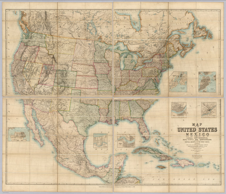
Author
[Johnston, Alexander Keith, 1804-1871, Rogers, Henry Darwin, Stanford, Edward]
Full Title
(Covers to) Map Of The United States And Mexico With Canada, New Brunswick, Nova Scotia and Newfoundland, And Parts Of Central America & The West Indies. Constructed From State Documents & Unpublished Materials By Professor H.D. Rogers of Boston U.S. and A. Keith Johnston, F.R.S.E Geographer to the Queen. London; Published by Edward Stanford, 6 Charing Cross, S.W. May 13th. 1861. Additions to 1869.
Publisher
Edward Stanford
Author
[Gibbes, C.D., Holt, Warren]
Full Title
Map of the States Of California And Nevada. Carefully Compiled from the Latest Authentic Sources. California By Julius H. Von Schmidt, Arthur W. Keddie, And C.D. Gibbes, C.E.'s. Nevada By Chas. Drayton Gibbes C.E. S.B. Linton Engr. & Lithogr. 148-1/2 S. 4th Street, Philadelphia. Comprising Information obtained from the U.S. Coast And Land Surveys; State Geological Surveys, By Prof. J.D. Whitney; Railroad Surveys And The Results Of Explorations Made By Brevet Lieut. Col. R.S. Williamson, U.S.A., Henry DeGroot, C.D. Gibbes, And Others. Published by Warren Holt. No. 411 Kearny Street, San Francisco, Cal. 1869. Entered ... 1868, by Warren Holt ... California. (with 1 inset).
Publisher
Warren Holt
Author
[Alaskan Boundary Tribunal, U.S. Coast Survey]
Full Title
(Facsimile) Tracing of part of "Alaska" shewing "Stakeen (Stickeen) River" from U.S. Coast Survey of 1869. Certified, Domn. Lands Office, Jan. 16th. 1878. The Burland Desbarats Lith. Co. Montreal.
Publisher
(U.S.) Government Printing Office
Author
[Alaskan Boundary Tribunal, Imray, James]
Full Title
(Facsimile) North Pacific (portion), London Published by James Imray and Son, 89 Minories and Tower Hill, 1869. Alaskan Boundary Tribunal, 1903. 33. Andrew B. Graham. Photo-Litho. Washington.D.C.
Publisher
Government Printing Office
1-25 of 25
|