Who What Where WhenREMOVE |
Full Title
L'Europe avec trois mers, trois fleuves & trois chaines de montagnes qui sont comunes a plus d'un pays. (1693)
Publisher
No Publisher
Full Title
L'Europe (avec trois mers, trois fleuves & trois chaines de montagnes qui sont comunes a plus d'un pays. 1693)
Publisher
No Publisher
Author
Mitchell, Samuel Augustus
Full Title
Western Hemisphere. Entered ... 1879 by S. Augustus Mitchell ... Washington. (1880)
Publisher
S.A. Mitchell
Author
Mitchell, Samuel Augustus
Full Title
Eastern Hemisphere. Entered ... 1879 by S. Augustus Mitchell ... Washington. (1880)
Publisher
S.A. Mitchell
Author
Fenner, Rest.
Full Title
A comparative view of the heights of the principal mountains and lengths of the principal rivers of the World. Fenner Sc., Paternoster Row. (London, Joseph Thomas, 1835)
Publisher
Joseph Thomas
Author
Lucas, Fielding Jr.
Full Title
Comparative Height of the Principal Mountains and other Elevations in the World. J. Cone Sc. Published by F. Lucas Jr. Baltimore.
Publisher
Fielding Lucas Jr.
Author
[Boue, Ami, 1794-1881, Johnston, Alexander Keith, 1804-1871]
Full Title
The geological structure of the globe according to Ami Boue, with corrections and additions to 1855. By A.K. Johnston, F.R.G.S. Engraved by W. & A.K. Johnston. William Blackwood & Sons, Edinburgh & London, (1856)
Publisher
William Blackwood & Sons
Author
Johnston, Alexander Keith, 1804-1871
Full Title
Comparative views of remarkable geological phenomena by A.K. Johnston, F.R.G.S. Engraved by W. & A.K. Johnston. William Blackwood & Sons, Edinburgh & London. (1856)
Publisher
William Blackwood & Sons
Author
[Berghaus, Heinrich, Johnston, Alexander Keith, 1804-1871]
Full Title
The river systems of Asia & Europe, showing the boundaries and comparative extent of the river basins & the oceans to which they contribute their waters. Extended from the original designs of Professor Berghaus, Berlin. By A.K. Johnston, F.R.G.S. Engraved by W. & A.K. Johnston. William Blackwood & Sons, Edinburgh & London. (1856)
Publisher
William Blackwood & Sons
Author
[Berghaus, Heinrich, Johnston, Alexander Keith, 1804-1871]
Full Title
The river systems of America, extended from the designs of Professor Berghaus, with additions of detailed maps of some of the principal hydrographical phenomena of the New World by A.K. Johnston, F.R.G.S. Corrected to 1855. Engraved by W. & A.K. Johnston. William Blackwood & Sons, Edinburgh & London. (1856)
Publisher
William Blackwood & Sons
Author
Greenleaf, Moses, 1777-1834
Full Title
Vertical sections, exhibiting the comparative altitudes of the principal highlands and rivers of the State of Maine. By Moses Greenleaf 1828. Engraved by W. Chapin for Greenleaf's Survey of Maine. Published by Shirley & Hyde, Portland, 1829.
Publisher
Shirley & Hyde
Author
Stieler, Adolf
Full Title
Fluss Und Bergkarte Von Deutschland Und Den Anliegenden Landern entworfen u. gez. von Adolf Stieler 1820. Neue vermehrte Auflage durch Herm. Berghaus. 1857. Druck von C. Hellfarth in Gotha. Gotha: Justus Perthes 1873.
Publisher
Justus Perthes
Author
[Andriveau-Goujon, J., Bruguiere, Louis]
Full Title
Tableau comparatif de la forme et de la hauteur des principales montagnes du globe terrestre, dedie a Monsieur le Baron, Alexdre. de Humboldt. A Paris, chez J. Andriveau-Goujon, Rue du Bac, no. 17. Par son tres humble et tres obeissant serviteur Louis Bruguiere. Grave par Ambroise Tardieu. (1850)
Publisher
J. Andriveau-Goujon
Author
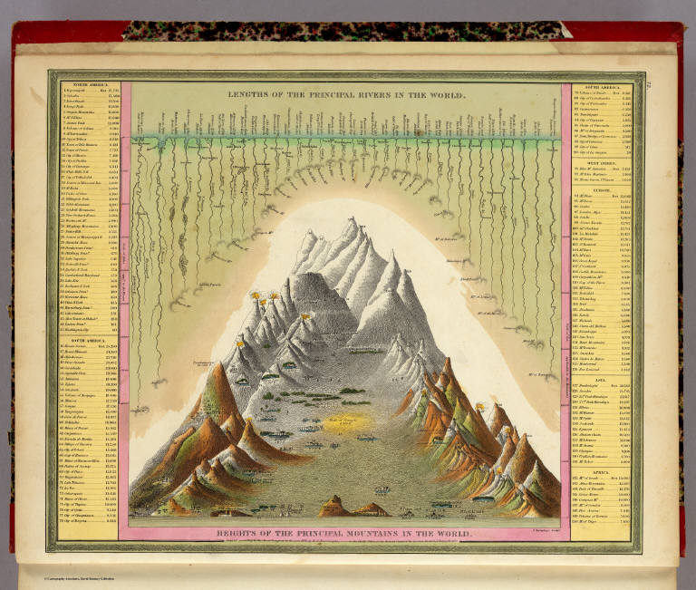
Mitchell, Samuel Augustus
Full Title
Heights Of The Principal Mountains In The World. Lengths Of The Principal Rivers In The World. F. Humphrys. Sculpt. Entered ... 1846, H.N. Burroughs ... Pennsylvania.
Publisher
S.A. Mitchell
Author
Codazzi, Agustin, 1793-1859
Full Title
(Un cuadro de alturas que comprende las de las cordilleras de Merida, de la costa de Caracas, Coro, Cumana y Margarita, y ultimamente las del sistema de la Parima. Otro cuadro comparativo de la superficie y poblacion de cada provincia. Otro de los principales rios que banan el territorio venezolano, ora procedentes de sus sistemas de montanas, ora de los Andes granadinos, o de la serrania de la Parima) Lith. de Thierry, freres, Paris. (Caracas 1840)
Publisher
[Agostino Codazzi, Thierry Freres.]
Author
Garcia Cubas, Antonio, 1832-1912
Full Title
Carta Orografica. VI. A. Garcia Cubas. Propiedad De Los Editores. Publicado por Debray Sucesores - Mexico.
Publisher
Debray Sucesores
Author
Berghaus, Heinrich
Full Title
Die Isothermkurven Der Nordlichen Halbkugel. 1ste. Abtheilung: Meteorologie No. 2. Gezeichnet v. Bar, Berghaus, u. Schelle. In Potsdam Gestochen von K. Kolbe. Gotha, J. Perthes. 1838.
Publisher
Justus Perthes
Author
[Goujon, J, Andriveau, J.]
Full Title
Tableau Comparatif et Figure de La Hauteur des Principales Montagnes et du Cours des Principaux Fleuves due Monde. Les Fleuves graves par Dumortier. Les Montagnes par A. Hocquart. La Lettre par Arnoul. Paris. Chez J. Goujon & J. Andriveau. Geographes - Editeurs. Rue du Bac, No. 6, Pres le Pont Royal. 1836.
Publisher
Goujon, J.; Andriveau, J.
Author
Colton, G.W.
Full Title
Mountains & Rivers.
Publisher
J. H. Colton.
Author
Colton, G.W.
Full Title
Mountains & Rivers. Published by G. W. & C. B. Colton & Co., No. 172 William St. New York.
Publisher
G. W & C. B. Colton & Co.
Author
Colton, G.W.
Full Title
(Index to) Principal Mountains in the World.
Publisher
G. W & C. B. Colton & Co.
Author
Martin de Moussy, V. (Victor), 1810-1869
Full Title
Coupes geologiques diverses - altitudes. Grave par Kautz, r. Bonaparte 82 - Paris. Paris - Imp. Lemercier, r. de Seine 57. (Paris Librairie de Firmin Didot Freres, Fils et Cie., 1873)
Publisher
Firmin Didot Freres.
Author
Martin de Moussy, V. (Victor), 1810-1869
Full Title
Coupes orographiques des parties centrales du territoire Argentin, de 260 a 330 L.S. Grave par Kautz, r. Bonaparte 82 - Paris. Paris - Imp. Lemercier, r. de Seine 57. (Paris Librairie de Firmin Didot Freres, Fils et Cie., 1873)
Publisher
Firmin Didot Freres.
Author
Martin de Moussy, V. (Victor), 1810-1869
Full Title
No. 1. Coupes du continent Sud Americain entre les Oceans Atlantique et Pacifique en moyenne sous le 33eme. de latitude en passant par l'extremite Sud du Massif central Argentin et la Cordillere de Mendoza. No. 2. Coupe sous le 40eme. parallele entre Valdivia et le Carmen pres l'embouchure du Rio Negro. No. 3. Coupe sous le 41eme. entre le Port Montt et le Carmen par le Lac de Nahuel-Huapi et le Rio Negro. Grave par Kautz, r. Bonaparte 82 - Paris. Paris - Imp. Lemercier, r. de Seine 57. (Paris Librairie de Firmin Didot Freres, Fils et Cie., 1873)
Publisher
Firmin Didot Freres.
Author
Hammond, C.S.
Full Title
The Northern and Northwestern Lakes including Canals and Tributary Navigable Streams.
Publisher
Garden City Publishing Company, Inc.
Author
Marschner, Francis J.
Full Title
Physical Features of the United States. Compiled and drawn by F. J. Marschner. Atlas of American Agriculture.
Publisher
U.S. Department of Agriculture
Author
Gray, Ormando Willis
Full Title
Mountains & Rivers.
Publisher
Stedman, Brown & Lyon
Author
Garcia Cubas, Antonio, 1832-1912
Full Title
Carta general de la Republica Mexicana. Formado en vista de los datos mas recientes y exactos que se han reunido con tal objeto, y constan en la noticia presentada al Exmo. Sr. Ministro de Fomento, por Antonio Garcia y Cubas. Lit. de Salazar. (Mexico: Imprenta de Lara, 1858)
Publisher
Imprenta de Jose Mariano Fernandez de Lara.
Author
Finley, Anthony
Full Title
Table of the Comparative Heights of the Principal Mountains &c. in the World ... Published by A. Finley Philada. Young & Delleker Sc.
Publisher
Anthony Finley
Author
Tanner, Henry S.
Full Title
Heights Of The Principal Mountains In The World. F. Humphrys sculpt. Published by H.S. Tanner, Philadelphia. Entered ... 1836, by H.S. Tanner ... Pennsylvania. (above neat line) Tanner's Universal Atlas.
Publisher
H.S. Tanner
Author
Mitchell, Samuel Augustus Jr.
Full Title
Western Hemisphere. Copyright by S. Augustus Mitchell 1884.
Publisher
Wm. M. Bradley & Bro.
Author
Mitchell, Samuel Augustus Jr.
Full Title
Eastern Hemisphere. Copyright by S. Augustus Mitchell 1884.
Publisher
Wm. M. Bradley & Bro.
Author
Tanner, Henry S.
Full Title
Heights Of The Principal Mountains In The World. F. Humphrys sculpt. Published by Carey & Hart, Philadelphia. Entered ... 1836, by H.S. Tanner ... Pennsylvania. (above neat line) Tanner's Universal Atlas.
Publisher
Carey and Hart
Full Title
Western Hemisphere. Copyright 1886 by Wm. M. Bradley & Bro.
Publisher
Wm. M. Bradley & Bro.
Full Title
Eastern Hemisphere. Copyright 1886 by Wm. M. Bradley & Bro.
Publisher
Wm. M. Bradley & Bro.
Author
[Black, Adam & Charles, Hall, Sidney, Hughes, William]
Full Title
Physical Geography. Edinburgh. Published by A. & C. Black. Engd. by Geo. Aikman.
Publisher
Adam & Charles Black
Author
[Carey, H. C., Lea, I.]
Full Title
Map And Description Of The Principal Mountains, &c. Throughout The World. Western Hemisphere. Eastern Hemisphere. Comparative Heights Of The Principal Mountains And Other Elevations In The World. No. 52. Arranged by F. Lucas Jr. Engraved by Young & Delleker.
Publisher
H.C. Carey & I. Lea
Author
[Carey, H. C., Lea, I.]
Full Title
Map Of The Principal Rivers Throughout The World. Comparative Lengths of the Principal Rivers throughout the World. No. 53. Drawn by F. Lucas Jr. J. Yeager Sculp.
Publisher
H.C. Carey & I. Lea
Author
[Martin, R.M., Tallis, J. & F.]
Full Title
A Comparative View Of The Principal Waterfalls, Islands, Lakes, Rivers and Mountains, In The Eastern Hemisphere. Designed & Engraved by John Rapkin. John Tallis & Company, London & New York.
Publisher
J. & F. Tallis
Author
[Martin, R.M., Tallis, J. & F.]
Full Title
A Comparative View Of The Principal Waterfalls, Islands, Lakes, Rivers and Mountains, In The Western Hemisphere. Designed & Engraved by John Rapkin. John Tallis & Company, London & New York.
Publisher
J. & F. Tallis
Author
Paz Soldan, Mariano Felipe, 1821-1886
Full Title
Cuadro general de alturas comparativas del Peru. Paz Soldan. Geografia del Peru. F. Delamare, 1865 Paris. Paris, Imp. Monrocq, Rue Suger 3. (Paris: Libreria de Augusto Durand, 1865)
Publisher
Libreria de Augusto Durand.
|