Browse All

1851 Nassau, Hessen Homburg, Frankfurt a/M. World Atlas Herzogthum Nassau, Landgrafschaft Hessen … |

1816 Ireland From The Best Authorities World Atlas Ireland From The Best Authorities. |

1816 Netherlands From The Best Authorities World Atlas Netherlands From The Best Authorities. |

1816 The Seven United provinces World Atlas The Seven United provinces From The Best … |

1816 Germany From the Best Authorities World Atlas Germany From The Best Authorities. John … |

1816 France World Atlas France &c. From Belleymes 4 Sheet Map Of … |

1845 Frankfurt a/M. World Atlas Frankfurt am Mayn, 1845. Aus der Geograp … |

1816 Switzerland With Its Subjects & Allies World Atlas Switzerland With Its Subjects & Allies F … |

1816 Italy From The Best Authorities World Atlas Italy From The Best Authorities. |

1816 Spain And Portugal From The Best Authori … World Atlas Spain And Portugal From The Best Authori … |

1816 Turkey In Europe and Hungary World Atlas Turkey In Europe and Hungary. |

1849 Mainz. World Atlas Plan von Mainz, 1849. (Aus der Geographi … |

1816 Asia World Atlas Asia. From Arrowsmiths Maps. (Engraved b … |

1816 Hindostan Or India World Atlas Hindostan Or India. From The Best Author … |

1816 Turkey In Asia World Atlas Turkey In Asia. Drawn From The Most Resp … |

1816 The Islands Of The East Indies World Atlas The Islands Of The East Indies, With The … |

1816 Africa World Atlas Africa. From Arrowsmiths Map Of Africa. |

1844 Hessen, Schaumburg, Cassel. World Atlas Neueste Karte von Kurfurstenthum Hessen. … |

1850 Thuringer-Wald-Gebirges. World Atlas Karte des Thuringer-Wald-Gebirges zuglei … |

1880 Chart of the World on Mercator's Project … World Atlas Chart of the World on Mercator's Project … |

1844 Gotha Herzogthum. World Atlas Neueste Karte vom Herzogth: Gotha und an … |

1880 Physical Map Europe. World Atlas Physical Map Europe. W. Swan Sonnenschei … |

1880 Physical Map Europe. World Atlas Physical Map Europe. W. Swan Sonnenschei … |

1880 Political Map of Europe. World Atlas Political Map of Europe. W. Swan Sonnens … |

1860 Sachsen. World Atlas Das Konigreich Sachsen entworfen und gez … |

1880 British Isles. World Atlas British Isles. W. Swan Sonnenschein & Al … |

1880 British Isles. World Atlas British Isles. W. Swan Sonnenschein & Al … |

1880 Physical Map of England. World Atlas Physical Map of England. W. Swan Sonnens … |

1880 Physical Map of England. World Atlas Physical Map of England. W. Swan Sonnens … |

1880 Political Map of England. World Atlas Political Map of England. W. Swan Sonnen … |

1851 Hannover. World Atlas Hannover entw. u. gez. vom Major Radefel … |

1880 Physical Map of Scotland. World Atlas Physical Map of Scotland. W. Swan Sonnen … |

1880 Physical Map of Scotland. World Atlas Physical Map of Scotland. W. Swan Sonnen … |

1880 Political Map of Scotland. World Atlas Political Map of Scotland. W. Swan Sonne … |

1880 Physical Map of Ireland. World Atlas Physical Map of Ireland. W. Swan Sonnens … |

1880 Physical Map of Ireland. World Atlas Physical Map of Ireland. W. Swan Sonnens … |

1890 Cover: Arbuckles' Illustrated Atlas of T … World Atlas (Cover to) Arbuckles' Illustrated Atlas … |

1890 England. United States. Bolivia. Egypt. World Atlas England. The United States. Bolivia. Egy … |

1890 France. Central America. Greenland. Swit … World Atlas France. Central America. Greenland. Swit … |

1890 Ecuador. Greece. Portugal. Morocco. World Atlas Ecuador. Greece. Portugal. Morocco. |

1890 Mexico. Newfoundland. Spain. Sandwich Is … World Atlas Mexico. Newfoundland. Spain. Sandwich Is … |
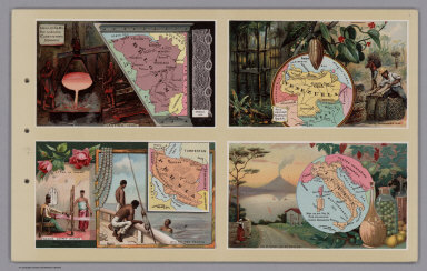
1890 Belgium. Venezuela. Persia. Italy. World Atlas Belgium. Venezuela. Persia. Italy. |

1890 German Empire. Paraguay. Cuba. Canada. World Atlas German Empire. Paraguay. Cuba. Dominion … |

1890 Chile. Denmark. Peru. Turkey. World Atlas Chili. Denmark. Peru. Turkey. |

1890 Scotland. Colombia. Austria. Sweden and … World Atlas Scotland. United States of Colombia. Aus … |

1890 Ireland. Japan. Central Africa. India. World Atlas Ireland. Japan. Central Africa. India. |

1890 Netherlands. Arabia. China. Afghanistan. World Atlas The Netherlands. Arabia. China. Afghanis … |

1890 Russia. Siberia. Uruguay. Australia. World Atlas Russia. Siberia. Uruguay. Australia. |

1890 Cape Colony (South Africa). Guiana. Arge … World Atlas Cape Colony (South Africa). Guiana. Arge … |

1890 (World Map labeled Arbuckles' Ariosa Cof … World Atlas (World Map labeled Arbuckles' Ariosa Cof … |