|
Author
American Atlas Company
Full Title
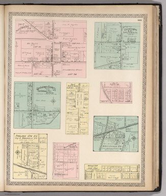
Map of West Part of the City of Niles.
Publisher
American Atlas Company
Author
American Atlas Company
Full Title
Map of Girard Village.
Publisher
American Atlas Company
Author
American Atlas Company
Full Title
Map of Mineral Ridge Village.
Publisher
American Atlas Company
Author
American Atlas Company
Full Title
Map of Cortland Village.
Publisher
American Atlas Company
Author
American Atlas Company
Full Title
Map of Newton Falls Village.
Publisher
American Atlas Company
Author
American Atlas Company
Full Title
Map of Kinsman P.O.
Publisher
American Atlas Company
Author
American Atlas Company
Full Title
West Farmington Village. Deforest P.O.
Publisher
American Atlas Company
Author
American Atlas Company
Full Title
Plats East of Vienna Center. Map of Leavittsburg P.O. or West Warren. Map of Johnston Center, Johnstonville P.O.
Publisher
American Atlas Company
Author
American Atlas Company
Full Title
Map of Brookfield Center. (Other areas in Trumbull Conty).
Publisher
American Atlas Company
Author
American Atlas Company
Full Title
Map of Orangeville Village. Map of Hartford Centre. Map of Vienna Center. Map of Burghill P.O. Kinsman Station, Farmdale P.O.
Publisher
American Atlas Company
Author
American Atlas Company
Full Title
Map of North Bloomfield P.O. Farmington P.O. Lordstown Center. Map of Fowler Center. Map of Tyrrell Mill. Phalanx Sta. P.O. Otis Coa Company Plat. Braceville P.O. Walnut Hill ot Bell's Plat.
Publisher
American Atlas Company
Author
American Atlas Company
Full Title
Map of West Metts P.O. Mesopotamia P.O. Map of Bristolville P.O. Bowmansville, Delightful P.O. Map of Dilworth P.O. Map of Gustavus Center. Map of Spokane P.O. Map of Mecca P.O. Map of Bristol P.O. Map of North Bristol.
Publisher
American Atlas Company
Author
American Atlas Company
Full Title
Map of Church Hill P.O. Map of Ohlton, Meander P.O. Mahoning Coal Co's Plat. Map of Coalburg P.O. Moorefield. Hanna Plat. Germantown. Longsville.
Publisher
American Atlas Company
Author
American Atlas Company
Full Title
Map Showing Congressional Districts of the State of Ohio. Map Showing Senatorial Districts of the State of Ohio.
Publisher
American Atlas Company
Author
American Atlas Company
Full Title
Map of Ohio. Showing System of Government Surveys.
Publisher
American Atlas Company
Author
[Cram, Geo. F., American Atlas Company]
Full Title
Ohio.
Publisher
American Atlas Company
Author
American Atlas Company
Full Title
Alaska (insets) Cook Inlet and Vicinity. Birch Creek and Tributaries. Klondike District.
Publisher
American Atlas Company
Author
American Atlas Company
Full Title
Map of South Part of the City of Warren.
Publisher
American Atlas Company
Author
American Atlas Company
Full Title
Map of East Part of the City of Niles.
Publisher
American Atlas Company
Author
American Atlas Company
Full Title
Map of Hubbard Village.
Publisher
American Atlas Company
Author
Reichsamt fur Landesaufnahme
Full Title
Sheet 650. Weilheim. Karte des Deutschen Reiches.
Publisher
Reichsamt fur Landesaufnahme
Author
Reichsamt fur Landesaufnahme
Full Title
(Composite of) Sheet 650. Weilheim. Karte des Deutschen Reiches.
Publisher
Reichsamt fur Landesaufnahme
Author
Reichsamt fur Landesaufnahme
Full Title
Sheet 663. Murnau. Karte des Deutschen Reiches.
Publisher
Reichsamt fur Landesaufnahme
Author
Reichsamt fur Landesaufnahme
Full Title
(Composite of) Sheet 663. Murnau. Karte des Deutschen Reiches.
Publisher
Reichsamt fur Landesaufnahme
Author
Reichsamt fur Landesaufnahme
Full Title
Sheet 357. Paderborn. Karte des Deutschen Reiches.
Publisher
Reichsamt fur Landesaufnahme
Author
Reichsamt fur Landesaufnahme
Full Title
(Composite of) Sheet 357. Paderborn. Karte des Deutschen Reiches.
Publisher
Reichsamt fur Landesaufnahme
Author
Reichsamt fur Landesaufnahme
Full Title
Sheet 381. Arnsberg. Karte des Deutschen Reiches.
Publisher
Reichsamt fur Landesaufnahme
Author
Reichsamt fur Landesaufnahme
Full Title
(Composite of) Sheet 381. Arnsberg. Karte des Deutschen Reiches.
Publisher
Reichsamt fur Landesaufnahme
Author
Reichsamt fur Landesaufnahme
Full Title
Sheet 404. Solingen. Karte des Deutschen Reiches.
Publisher
Reichsamt fur Landesaufnahme
Author
Reichsamt fur Landesaufnahme
Full Title
(Composite of) Sheet 404. Solingen. Karte des Deutschen Reiches.
Publisher
Reichsamt fur Landesaufnahme
Author
Reichsamt fur Landesaufnahme
Full Title
Sheet 406. Attendorn. Karte des Deutschen Reiches.
Publisher
Reichsamt fur Landesaufnahme
Author
Reichsamt fur Landesaufnahme
Full Title
(Composite of) Sheet 406. Attendorn. Karte des Deutschen Reiches.
Publisher
Reichsamt fur Landesaufnahme
Author
Reichsamt fur Landesaufnahme
Full Title
Sheet 208. Rotenburg i/Hann. Karte des Deutschen Reiches.
Publisher
Reichsamt fur Landesaufnahme
Author
Reichsamt fur Landesaufnahme
Full Title
(Composite of) Sheet 208. Rotenburg i/Hann. Karte des Deutschen Reiches.
Publisher
Reichsamt fur Landesaufnahme
Author
Reichsamt fur Landesaufnahme
Full Title
Sheet 281. Bentheim. Karte des Deutschen Reiches.
Publisher
Reichsamt fur Landesaufnahme
Author
Reichsamt fur Landesaufnahme
Full Title
(Composite of) Sheet 281. Bentheim. Karte des Deutschen Reiches.
Publisher
Reichsamt fur Landesaufnahme
Author
Reichsamt fur Landesaufnahme
Full Title
Sheet 282. Rheine. Karte des Deutschen Reiches.
Publisher
Reichsamt fur Landesaufnahme
Author
Reichsamt fur Landesaufnahme
Full Title
(Composite of) Sheet 282. Rheine. Karte des Deutschen Reiches.
Publisher
Reichsamt fur Landesaufnahme
Author
Reichsamt fur Landesaufnahme
Full Title
Sheet 283. Osnabruck. Karte des Deutschen Reiches.
Publisher
Reichsamt fur Landesaufnahme
Author
Reichsamt fur Landesaufnahme
Full Title
(Composite of) Sheet 283. Osnabruck. Karte des Deutschen Reiches.
Publisher
Reichsamt fur Landesaufnahme
Author
Reichsamt fur Landesaufnahme
Full Title
Sheet 285. Minden. Karte des Deutschen Reiches.
Publisher
Reichsamt fur Landesaufnahme
Author
Reichsamt fur Landesaufnahme
Full Title
(Composite of) Sheet 285. Minden. Karte des Deutschen Reiches.
Publisher
Reichsamt fur Landesaufnahme
Author
Reichsamt fur Landesaufnahme
Full Title
Sheet 286. Hannover. Karte des Deutschen Reiches.
Publisher
Reichsamt fur Landesaufnahme
Author
Reichsamt fur Landesaufnahme
Full Title
(Composite of) Sheet 286. Hannover. Karte des Deutschen Reiches.
Publisher
Reichsamt fur Landesaufnahme
Author
Reichsamt fur Landesaufnahme
Full Title
Sheet 287. Lehrte. Karte des Deutschen Reiches.
Publisher
Reichsamt fur Landesaufnahme
Author
Reichsamt fur Landesaufnahme
Full Title
(Composite of) Sheet 287. Lehrte. Karte des Deutschen Reiches.
Publisher
Reichsamt fur Landesaufnahme
Author
Reichsamt fur Landesaufnahme
Full Title
Sheet 297. Zielenzig. Karte des Deutschen Reiches.
Publisher
Reichsamt fur Landesaufnahme
Author
Reichsamt fur Landesaufnahme
Full Title
Sheet 298.1. Meseritz. Karte des Deutschen Reiches.
Publisher
Reichsamt fur Landesaufnahme
Author
Reichsamt fur Landesaufnahme
Full Title
(Composite of) Sheet 298.1. Meseritz. Karte des Deutschen Reiches.
Publisher
Reichsamt fur Landesaufnahme
|