|
Author
Mitchell, Samuel Augustus
Full Title
Map Of Virginia And Maryland Constructed from the Latest Authorities. Published by S. Augustus Mitchell Philadelphia. 1831. J.H. Young Sc. (inset) Plan Of Washington City & Georgetown.
Publisher
S.A. Mitchell
Author
Burr, David H., 1803-1875
Full Title
Map of Virginia, Maryland and Delaware Exhibiting the Post Offices, Post Roads, Canals, Rail Roads, &c. By David H. Burr. (Late Topographer to the Post Office.) Geographer to the House of Representatives of the U.S. John Arrowsmith. Entered ... July 10th, 1839, by David H. Burr ... District of Columbia.
Publisher
John Arrowsmith
Author
Colton, G.W.
Full Title
Delaware And Maryland. (with) District of Columbia. Published by J.H. Colton & Co. 172 William St. New York. Entered ... 1855 by J.H. Colton & Co. ... New York. No. 22.
Publisher
J.H. Colton
Author
Colton, G.W.
Full Title
City Of Baltimore Maryland. Published by J.H. Colton & Co. 172 William St. New York. Entered ... 1855 by J.H. Colton & Co. ... New York. No. 23.
Publisher
J.H. Colton
Author
[Reid, John, Winterbotham, W.]
Full Title
The States of Maryland and Delaware, from the latest Surveys. 1795. D. Martin scupt. Published by Wayland, Reid & Smith. (with inset) Continuation of the Potowmac River from Fort Cumberland.
Publisher
John Reid
Author
Jefferys, Thomas
Full Title
A Map of the most Inhabited part of Virginia containing the whole province of Maryland with Part of Pensilvania, New Jersey and North Carolina. Drawn by Joshua Fry & Peter Jefferson in 1775. Printed for Robt. Sayer ... London. (Northern Section)
Publisher
Sayer and Bennett
Author
Henshaw, Frances A.
Full Title
Maryland.
Publisher
Manuscript
Author
Schonberg & Co.
Full Title
Schonberg's Map of Pennsylvania, New Jersey, Maryland and Delaware. Entered ... 1866 ...New York.
Publisher
Schonberg & Co.
Author
Shell Oil Company
Full Title
Shell Map of Delaware - Maryland, Virginia - W. Virginia (cover title). Shell Highway Map of Delaware - Maryland, Virginia, W. Virginia. (eastern portion). 7-DD-1956-2. (inset) Shenandoah National Park.
Publisher
Shell Oil Company
Author
Shell Oil Company
Full Title
Shell Highway Map of Delaware - Maryland, Virginia, W. Virginia. (western portion). (Verso to) Shell Highway Map of Delaware - Maryland, Virginia, W. Virginia. (eastern portion).
Publisher
Shell Oil Company
Author
Cram, George Franklin
Full Title
Maryland and Delaware, Engraved Exclusively for the Standard Atlas of the World. (inset) Baltimore County.
Publisher
George F. Cram
Author
Colton, G.W.
Full Title
Colton's Baltimore, Maryland. Published By G. W & C. B. Colton & Co., No. 182 William St. New York.
Publisher
G. W & C. B. Colton & Co.
Author
Colton, G.W.
Full Title
Colton's Delaware, Maryland, Virginia and West Virginia. (insets) District of Columbia; Richmond, Henrico County, Manchester and Spring Hill, Chesterfield County, Norfolk, Portsmouth and Gosport. Published By G. W & C. B. Colton & Co. No. 182 William St. New York.
Publisher
G. W & C. B. Colton & Co.
Author
Colton, G.W.
Full Title
Colton's Delaware And Maryland. (Inset) District of Columbia. Published By G. W & C. B. Colton & Co. No. 172 William St. New York.
Publisher
G. W & C. B. Colton & Co.
Author
Colton, G.W.
Full Title
Colton's Delaware and Maryland. (inset) District of Columbia. Published by G.W. & C.B. Colton & Co., No. 172 William St. New York.
Publisher
G.W. & C.B. Colton
Author
Colton, G.W.
Full Title
Colton's City of Baltimore, Maryland. Published By G. W. & C.B. Colton. No. 172 William St. New York.
Publisher
G.W. & C.B. Colton
Author
Asher & Adams
Full Title
Asher & Adams' Delaware, Maryland, Virginia, West Virginia & District of Columbia. Entered according to Act of Congress in the year 1874 by Asher & Adams ... at Washington. (New York, 1874)
Publisher
Asher and Adams
Author
Schonberg & Co.
Full Title
Maryland and Delaware. Ohio and Indiana.
Publisher
Schonberg & Co.
Author
Cram, George Franklin
Full Title
Maryland and Delaware. (inset) Baltimore County.
Publisher
George F. Cram
Author
Mitchell, Samuel Augustus
Full Title
A New Map of Maryland and Delaware, with Their Canals, Roads & Distances. Published by Thomas, Cowperthwait & Co., No. 253 Market Street, Philadelphia. Entered ... 1850, by Thomas, Cowperthwait & Co. ... Pennsylvania.
Publisher
Thomas, Cowperthwait & Co.
Author
Mitchell, Samuel Augustus Jr.
Full Title
County Map of Maryland and Delaware. County Map of New Jersey. Entered ... 1874 by S. Augustus Mitchell ... Washington.
Publisher
Ziegler & McCurdy
Author
Johnson, A.J.
Full Title
Johnson's Virginia, Delaware, and Maryland. By Johnson and Ward.
Publisher
Johnson and Ward
Author
Johnson, A.J.
Full Title
Johnson's Delaware and Maryland By Johnson and Ward. (inset) District of Columbia.
Publisher
Johnson and Ward
Author
Mitchell, Samuel Augustus
Full Title
A new map of Maryland and Delaware, with their Canals, Roads & Distances. Published by Thomas, Cowperthwait & Co. No. 253 Market Street, Philadelphia. Entered ... 1850 by Thomas, Cowperthwait & Co. ... Pennsylvania.
Publisher
Cowperthwait, Desilver & Butler
Author
[Jones, C.H., Hamilton, T.H., Williams, J.David]
Full Title
Map of Delaware, Maryland, Virginia, West Virginia, North Carolina, Kentucky, Tennessee, Ohio and Indiana.
Publisher
J. David Williams
Author
[Bayer, Herbert, Container Corporation of America]
Full Title
Delaware. Maryland. U.S. States. District of Columbia.
Publisher
Container Corporation of America
Author
[Carey, Mathew, Warner, Benjamin]
Full Title
Maryland. (Engraved by) W. Barker, sculp. (inset) Maryland, West Of Cumberland.
Publisher
M. Carey and B. Warner
Author
[Breese, Samuel, 1802-1873, Morse, Sidney E. (Sidney Edwards), 1794-1871]
Full Title
Maryland and Delaware. (with) District of Columbia. (By Sidney E. Morse and Samuel Breese. New York: Published by Harper & Brothers, 1845)
Publisher
Harper & Brothers
Author
[Vorzet, Ed.Dumas, Le Comte de Paris]
Full Title
Planche II. Virginie et Maryland. (inset) Environs de Leesburg. Carnifex Ferry. Dessine par Ed. Dumas Vorzet. Michel Levy, freres. Editeurs. Imp. Becquet, Paris. Grave par L. Wuhrer, R. Gay-Lussac 52.
Publisher
Michel Levy Freres
Author
[Vorzet, Ed.Dumas, Le Comte de Paris]
Full Title
Planche XVI. Antietam (Maryland). Cedar Mountain (Virginie). Harpers Ferry et South Mountain. Dessine par Ed. Dumas Vorzet. Michel Levy, freres. Editeurs. Imp. Becquet, Paris. Grave par L. Wuhrer, R. Gay-Lussac 52.
Publisher
Michel Levy Freres
Author
[Vorzet, Ed.Dumas, Le Comte de Paris]
Full Title
Planche XXIV. Vallee du Monocacy et Contrees Voisines. Dessine par Ed. Dumas Vorzet. Michel Levy, freres. Editeurs. Imp. Becquet, Paris. Grave par L. Wuhrer, R. Gay-Lussac 52.
Publisher
Michel Levy Freres
Author
[Howe, Samuel Gridley, Ruggles, Samuel P.]
Full Title
Map of Maryland and Delaware.
Publisher
New England Institution for the Education of the Blind
Author
[Howe, Samuel Gridley, Ruggles, Samuel P.]
Full Title
Virginia and Maryland
Publisher
New England Institution for the Education of the Blind
Author
[U.S. War Department, Weyss, John E.]
Full Title
Antietam. Prepared by Bvt. Brig. Gen N. Michler, Major of Engineers from Surveys under his direction by order of Brig. Genl. & Bvt. Maj. Genl. A.A. Humphreys, Chief of Engineers and under the Authority of the Hon. Secretary of War. 1867. Surveyed & drawn by Maj. J.E. Weyss, assisted by F. Theilkuhl, J. Strasser & G. Thompson. Photolith. by the N.Y. Lithographing, Engraving & Printing Co., Julius Bien, Supt. (under War Department Seal) 1869.
Publisher
N.Y. Lithographing, Engraving & Printing Co.
Author
Johnson, A.J.
Full Title
Johnson's Delaware and Maryland. (inset) District of Columbia. Entered ... 1868.
Publisher
A.J. Johnson
Author
Johnson, A.J.
Full Title
Johnson's Virginia, Delaware, Maryland & West Virginia. Entered ... 1864.
Publisher
A.J. Johnson
Author
Meyer, Joseph, 1796-1856
Full Title
Neueste Karte von Maryland und Delaware mit seinen Canaelen, Strassen und Entfernungen der Hauptpunkte. 1846. (with) Grundriss von Baltimore. Aus der Graviranstalt des Bibliographischen Instituts zu Hildburghausen, Amsterdam, Paris u. Philadelphia, (1860)
Publisher
Bibliographischen Instituts
Author
[Hesselbach, W., U.S. War Department, Topographical Engineers, United States. War Department, Young, J. J.]
Full Title
Surveys for military defenses. Map of northeastern Virginia and vicinity of Washington. Sheet 1. Compiled in Topographical Engineers Office at division headquarters of General Irvin McDowell, Arlington, January 1, 1862. Corrected from recent surveys and reconnaissances under direction of the Bureau of Topographical Engineers, August 1, 1862. Drawn by J.J. Young and W. Hesselbach. Julius Bien & Co., Lith., N.Y. (1891-1895)
Publisher
U.S. Government Printing Office
Author
[Hesselbach, W., U.S. War Department, Topographical Engineers, United States. War Department, Young, J. J.]
Full Title
Surveys for military defenses. Map of northeastern Virginia and vicinity of Washington. Sheet 2. Compiled in Topographical Engineers Office at division headquarters of General Irvin McDowell, Arlington, January 1, 1862. Corrected from recent surveys and reconnaissances under direction of the Bureau of Topographical Engineers, August 1, 1862. Drawn by J.J. Young and W. Hesselbach. Julius Bien & Co., Lith., N.Y. (1891-1895)
Publisher
U.S. Government Printing Office
Author
U.S. War Department, Topographical Engineers
Full Title
Part of map of portions of the military departments of Washington, Pennsylvania, Annapolis and Northeastern Virginia. Compiled in the Bureau of Topographical Engrs., War Department &c., July 1861 ... report of Maj. Gen. Geo. B. McClellan ... and Maj. A.J. Myer ... Battle-fields of South Mountain showing the positions of the forces of the United States and of the enemy during the battle fought by the Army of the Potomac under the command of Maj. Gen. Geo. B. McClellan, Sept. 14, 1862. Prepared in the Bureau of Topographical Engineers. (with) Map accompanying Lieutenant General Pemberton's report of operations near Vicksburg, Miss., December 21, 1862, January 2, 1863. Surveyed and drawn by H.A. Pattison, Civil Engr. Julius Bien & Co., Lith., N.Y. (1891-1895)
Publisher
U.S. Government Printing Office
Author
[Bowen, Nicolas, United States. War Department]
Full Title
Map of the battle of the Antietam fought on the 16th and 17th September 1862 between the United States forces under the command of Maj. Gen. Geo. B. McClellan and the Confederates under Gen. Robert E. Lee. Prepared ... under the direction of 1st Lt. Nicholas Bowen ..., 1st Lt. A.H. Cushing ..., Chas. Shoemacker, E.F. Bowke, Jos. McMakin, C.A. Mallory, assts. ... October 1862. (with) Map of the battle of the Antietam ... sketched under the direction of Capt. J.C. Duane ... by Maj. D.C. Houston ..., Lt. N. Bowen, Lt. Js. H. Wilson, Lt. Jno. M. Wilson ..., Lt. W.A. Roebling ..., W.S. Long ..., Jos. McMackin ... (with) Engagement at deserted house or Kelly's Store near Suffolk, Va., January 30th 1863 (with) Battle-field of Gettysburg, July 1-4, 1863. Drawn by Thomas Peters ... (with) Map of the position of the cavalry during the engagement of April 4th 1863 ... (with) Map of that portion of the battle-field of Antietam occupied by the troops under Maj. Gen. Burnside ... from surveys made under the supervision of Capt. R.S. Williamson ... by H.C. Fillebrown, E.S. Waters, Civ. Eng'rs. Julius Bien & Co., Lith., N.Y. (1891-1895)
Publisher
U.S. Government Printing Office
Author
[Michler, Nathaniel, United States. War Department]
Full Title
Antietam. Prepared by Bvt. Brig. Gen. N. Michler, Major of Engineers from surveys under his direction ... 1867. Compiled and drawn by Maj. J.E. Weyss, assisted by F. Theilkuhl, J. Strasser and G. Thompson. ... Map of the battle-fields of Harper's Ferry and Sharpsburg with position of troops, routes of Army &c., Sept. 13 to 17, 1862 ... by S. Howell Brown, 1st. Lieut. Engr. Troops ... Jan. 27, 1864. To accompany report of General Robert E. Lee, C.S. Army. Julius Bien & Co., Lith., N.Y. (1891-1895)
Publisher
U.S. Government Printing Office
Author
United States. War Department
Full Title
Military map showing the topographical features of the country adjacent to Harper's Ferry, Va. including Maryland, Loudoun and Bolivar heights and portions of South and Short mountains with the positions of the defensive works, also the junction of the Potomac and Shenandoah rivers and their passage through the Blue Ridge. Surveyed from August 3d to Sept. 30th 1863 under the direction of Capt. N. Michler, Corps of Engrs., U.S. Army, by Major John E. Weyss ... Army of the Potomac. Map of the vicinity of Hagerstown, Funkstown, Williamsport and Falling Waters, Md. Accompanying the report of Major General G.G. Meade on the Battle of Gettysburg dated October 1st 1863. (with) Battle of Slaughter's Mountain, sketch of field August 9, 1862. (with) Sketch of that part of field at Cold Harbor where Ewell's Division operated, particularly where Trimble's Brigade fought, June 27, 1862. (with) Sketch of the battle-field of Cross Keys, Va., June 8, 1862. ... Julius Bien & Co., Lith., N.Y. (1891-1895)
Publisher
U.S. Government Printing Office
Author
[Confederate States of America. Army of Northern Virginia, Confederate States of America. Army, Hoffman, J. Paul, Hoffman, United States. War Department]
Full Title
Map of Orange County &c., Va. embracing the details and plan of operations of Confederate and Federal forces at Mine Run and Rapidan River by order of ... W.P. Smith, Lt., Col. of Engrs., Topl. Office, A.N.V. Prepared by J. Paul Hoffman. Accompanying report of General R.E. Lee, C.S. Army. (with) Part of map of portions of the military departments of Washington, Pennsylvania, Annapolis and Northeastern Virginia. Compiled in the Bureau of Topographical Engrs., War Department &c., 1861. Accompanying report of Capt. L.B. Norton ... (with Decatur, Howard's Plantation). From original in possession of Gen. W.T. Sherman. (with Brownings C.H.-Stone Mountain) C.B. Reese, Capt. Engrs. From original in possession of Gen W.T. Sherman. (with Campbellton Region) Accompanying letter of Maj. Gen. George Stoneman. (with) Map to show lines of march of Second Army Corps and the enemy, Oct. 14, 1863 ... report of ... G.K. Warren. (with) Map of battle-field at Bristoe fought by 2d Army Corps commanded by Maj. Gen. G.K. Warren, October 14, 1863. (with) Map of Missionary Ridge, Tenn. showing the positions attacked by the forces under the command of Maj. Gen. W.T. Sherman, Nov. 24th and 25th, 1863. Julius Bien & Co., Lith., N.Y. (1891-1895)
Publisher
U.S. Government Printing Office
Author
United States. War Department
Full Title
Map of Texas and part of New Mexico, compiled in the Bureau of Topographl. Engrs. chiefly for military purposes. Information on this map furnished by Wm. E. Young, C.E. and compiled under the direction of Maj. D.C. Houston, Chief Engr., Dept. of the Gulf. Accompanying letter of Gen. N.P. Banks ... (with) Plan of the battle-field at New Creek, W. Va., August 4th, 1864. (with) Plan of the battle-field at Pleasant Mills near Cumberland, Md., August 1st, 1864. Made by F.M. Knight. ... Julius Bien & Co., Lith., N.Y. (1891-1895)
Publisher
U.S. Government Printing Office
Author
[Gillespie, George L., United States. War Department]
Full Title
Engineer Office, Military Division of the Gulf. Map no. 5. Upper Potomac from McCoy's Ferry to Conrad's Ferry and adjacent portions of Maryland and Virginia showing the operations of the Army of the Shenandoah. Commanded by Maj. Gen. P.H. Sheridan, U.S.A. Drawn and lithographed under the direction of Bvt. Maj. G.L. Gillespie ... October 1865. (with) Sheet no. 2. Map of the battle-field of Cedar Creek, Va. fought Oct. 19th, 1864 and cavalry fight of Tom's Brook fought Oct. 9th 1864. Union forces commanded by Maj. Gen. P.H. Sheridan, U.S.A. Confederate forces commanded by Lieut. Gen. J.A. Early, C.S.A. Drawn and lithographed under the direction of ... Col. G. Gillespie ... (with) Map showing the march routes of the Army of the Tennessee from Atlanta to Savannah during the campaign in Georgia, under the command of Maj. Gen. O.O. Howard. Compiled and drawn under the direction of Capt. C.B. Reese ... by L. Helmle ... (with) Plate showing positions of the 15th Army Corps, Maj. Gen. P.J. Osterhaus, commanding in front of Savannah, Ga., Dec. 1864. Drawn by C. v. Seutter. Julius Bien & Co., Lith., N.Y. (1891-1895)
Publisher
U.S. Government Printing Office
Author
[Campbell, Albert H., Confederate States of America. Army of Northern Virginia, Confederate States of America. Army, Hotchkiss, Jed.]
Full Title
No. 1. Map from Maj. A.H. Campbell's surveys showing the positions of the camps and pickets of the 2d Corps, A.N. Va., May 3d 1864 and the routes of march from May 4th to May 21st 1864, battles of the Wilderness and Spotsylvania C.H., Va. To accompany report of Jed. Hotchkiss, Top. Eng., V.D. No. 5. Map from Maj. A.H. Campbell's surveys showing the routes and positions of the 2d Corps, A.N. Va., to accompany report of Jed. Hotchkiss ... No. 7. Map from Maj. A.H. Campbell's surveys showing the routes, camps and positions of the 2d Corps, A.N. Va. from May 27th to June 13th 1864 to accompany report of Jed. Hotchkiss ... No. 11. Map showing routes and camps of the Army of the Valley Dist. from Staunton, Va. to Washington, D.C. and back to Strasburg, Va. from June 27th to July 22d 1864, to accompany report of Jed. Hotchkiss ... (with) No. 99. Wickham's attack on Fed. Cav., Nov. 22d 1864. (with) No. 8. Map showing the routes and camps of the 2d Corps, A.N.V. from Gaines' Mill to Lynchburg, Va., June 13th to 18th 1864 and of the Army of the Valley District from Lynchburg to Salem and Staunton, Va., June 19th to 27th, 1864. (with) No. 6. Map from Maj. A.H. Campbell's surveys showing position of 2d Corps, A.N. Va., at Hanover Junction, Va., May 22d to May 27th 1864 ... Julius Bien & Co., Lith., N.Y. (1891-1895)
Publisher
U.S. Government Printing Office
Author
[Confederate States of America. Army of Northern Virginia, Confederate States of America. Army, Hotchkiss, Jed.]
Full Title
No. 29. Sketch of the battle of Belle Grove on Cedar Creek, Wednesday October 19th 1864. Prepared to accompany report of Lieut. Gen. J.A. Early, commanding A.V.D., by Jed. Hotchkiss, Top. Eng. A.V.D. (with) No. 12. Map of engagement at Harper's Ferry, Va., July 4th, 1864. (with) No. 17. Map of cavalry action at Martinsburg, Va., July 25th, 1864. (with) No. 18. Map showing routes, camps and engagements of McCausland's and Johnson's brigades of Cavalry from July 29th to August 8th 1864, burning of Chambersburg. (with) No. 19. Sketch of action at Guard Hill, Aug. 16th 1864. (with) No. 21. Sketch of actions near Kearneysville and Shepherdstown, Va., Thursday August 25th 1864. (with) No. 20. Sketch of engagement at Charlestown, Va., Sunday Aug. 21st 1864. (with) No. 22. Sketch of engagement at Opequon Bridge and Smithfield, Va., Monday Aug. 29th 1864. (with) No. 24. Sketch of the cavalry action of Fitz Lee's division at Gooney Run, Warren Co., Va., Tuesday Sept. 20th 1864. (with) No. 23. Sketch of the battle of Berryville, Va. by Kershaw's division, Saturday Sept. 3d 1864 and position of the Army of the Valley, Sunday Sept. 4th 1864. (with) No. 26. Map of the line of intrenchments (sic) at Fisher's Hill, Va., Aug. 13th to 17th 1864, Battle of Fisher's Hill, Sept. 22d 1864. (with) No. 27. Map of cavalry engagement near Bridgewater, Va., Oct. 4th and 5th 1864 by Jed. Hotchkiss ... Julius Bien & Co., Lith., N.Y. (1891-1895)
Publisher
U.S. Government Printing Office
Author
[Confederate States of America. Army of Northern Virginia, Confederate States of America. Army, Hotchkiss, Jed.]
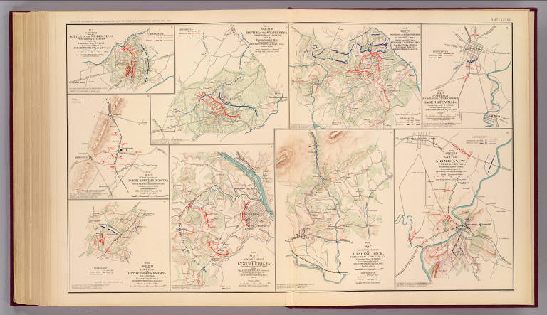
Full Title
No. 10. Map of engagement at Hanging Rock, Roanoke County, Va., Tuesday, June 21st, 1864. No. 15. Sketch of the battle Monocacy, Frederick Co., Md., Saturday July 9th 1864. (with) No. 2. Sketch of the battle of the Wilderness. Position of 2d Corps. A.N. Va., Thursday May 5th 1864. (with) No. 3. Sketch of the battle of the Wilderness. Position of 2d Corps, A.N. Va., Friday May 6th 1864. (with) No. 4. Sketch showing positions and entrenchments of the 2d Corps, A.N. Va., during the battles of Spotsylvania C.H., Va. from May 9th to May 21st 1864. (with) No. 14. Map of action of McCausland's cavalry brigade at Hagerstown, Md., Thursday July 7th 1864. (with) No. 13. Map of the capture of North Mountain Depot, Va. by McCausland's cavalry brigade, Monday July 4th 1864. (with) No. 16. Sketch of the battle of Rutherford's Farm, Va., July 20th 1864. (with) No. 9. Map of engagement near Lynchburg, Va., Saturday June 18th 1864, from Maj. A.H. Campbell's surveys. (all) To accompany report of Jed. Hotchkiss, Top. Eng. ... Julius Bien & Co., Lith., N.Y. (1891-1895)
Publisher
U.S. Government Printing Office
Author
[Confederate States of America. Army of Northern Virginia, Confederate States of America. Army, Hotchkiss, Jed.]
Full Title
Map of route of the Army of the Valley from Franklin, Pendleton Co., Va. May 15th 1862 to the battle of Winchester, May 25th 1862 and the pursuit of the enemy ... 1863. Sketch of the battle of Winchester, Va., Sunday May 25th 1862 ... Route of Gen. Jackson's army to the battle of Cedar Run, Va. ... 1863. Sketch of the battle of Cedar Run, Va., Saturday August 9th 1862 ... Sketch of the battles of Port Republic, Va., June 8th and 9th 1862 ... (all) by Jed. Hotchkiss ... (with) Sketches accompanying journal of Capt. Jed. Hotchkiss, C.S. Army, Chief Engr. 2d Corps, A. of N.V., Valley District. Julius Bien & Co., Lith., N.Y. (1891-1895)
Publisher
U.S. Government Printing Office
|