Who What Where WhenREMOVE |
Author
Colton, G.W.
Full Title
Colton's Map of California, Nevada, Utah, Colorado, Arizona & New Mexico. Published By J. H. Colton. No. 172 William St. New York.
Publisher
J. H. Colton.
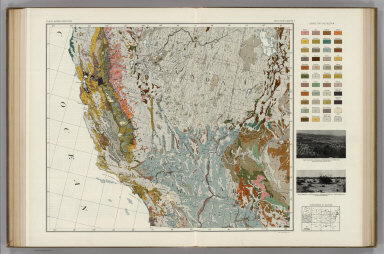
Author
Marbut, Curtis F.
Full Title
Soil Map of the United States by Curtis F. Marbut and Associates in the Soil Survery, U.S. Department of Agriculture, F.J. Marschner, Cartographer and Associate in Compilation. 1931. Soils, Plate 5, Section 5. Lith. A. Hoen & Co., Inc. Atlas of American Agriculture.
Publisher
U.S. Department of Agriculture
Author
Gray, Ormando Willis
Full Title
Gray's Atlas California and Nevada. (inset) The Vicinity of San Francisco. (inset) Map of the Yosemite Valley, Mariposa Co., Cal. from the California Geological Survey.
Publisher
Stedman, Brown & Lyon
Author
Gray, Ormando Willis
Full Title
Gray's Atlas New Railroad and County Map of the States of Oregon, California, and Nevada Compiled and Drawn by Frank A. Gray. Published by O.W. Gray, Philadelphia. (inset) Enlarged Plan of the Vicinity of San Francisco and Sacramento.
Publisher
Stedman, Brown & Lyon
Author
Rand McNally and Company
Full Title
Commercial Atlas of America. Rand McNally Black and White Mileage Map, California and Nevada.
Publisher
Rand McNally and Company
Author
Rand McNally and Company
Full Title
Commercial Atlas of America. (Rand McNally Auto Trails Map, District No. 15-16. California, Nevada. Northern Section).
Publisher
Rand McNally and Company
Author
Rand McNally and Company
Full Title
Commercial Atlas of America. Rand McNally Auto Trails Map, District No. 15-16. (California, Nevada. Southern Section).
Publisher
Rand McNally and Company
Author
Gray, Ormando Willis
Full Title
California and Nevada. (inset) Map of Yosemite Valley, Mariposa County, Cal. (inset) Plan of Sacramento. (inset) The Vicinity of San Francisco.
Publisher
O.W. Gray & Son
|