Who What Where WhenREMOVE |
Author
Colton, G.W.
Full Title
Territories Of New Mexico and Utah. Published By J.H. Colton & Co. No. 172 William St. New York. Entered ... 1855 by J.H. Colton & Co. ... New York. No. 51.
Publisher
J.H. Colton
Author
Humboldt, Alexander von, 1769-1859
Full Title
Carte de la Route qui mene depuis la Capitale de la Nouvelle Espagne jusqu'a S. Fe de Nouveau Mexique. Dressee sur les Journaux de Don Pedro de Rivera et en partie sur les Observations Astronomiques de Mr. de Humboldt. 6-8. Dessine et redige par F. Friesen, a Berlin 1807.
Publisher
F. Schoell
Author
Asher & Adams
Full Title
Asher & Adams' New Mexico. Entered according to Act of Congress in the year 1873 by Asher & Adams ... at Washington. (New York, 1874)
Publisher
Asher and Adams
Author
Shell Oil Company
Full Title
Shell Map of Arizona, New Mexico (cover title). Shell Highway Map of Arizona and New Mexico. 7-Y-1951-2.
Publisher
Shell Oil Company
Author
Shell Oil Company
Full Title
Santa Fe and Vicinity. Lincoln National Forest Region. Santa Fe. Tucson. Phoenix. Albuquerque. Grand Canyon National Park. Carlsbad Caverns National Park. Petrified Forest National Monument. (Verso to) Shell Highway Map of Arizona and New Mexico.
Publisher
Shell Oil Company
Author
Shell Oil Company
Full Title
Shell Map of New Mexico (cover title). Shell Highway Map of New Mexico. 6-DD-1956-1. (insets) Albuquerque. Santa Fe.
Publisher
Shell Oil Company
Author
Shell Oil Company
Full Title
Santa Fe and Vicinity. (Verso to) Shell Highway Map of New Mexico.
Publisher
Shell Oil Company
Author
Vandermaelen, Philippe, 1795-1869
Full Title
Partie du Mexique. Amer. Sep. no. 54. Dressee et dessinee par Ph. Vandermaelen. Dessee. sur pierre et Lithogrie. par H. Ode. Juin 1825. (Quatrieme partie. - Amer. sept. Bruxelles. 1827)
Publisher
Ph. Vandermaelen
Author
[Delavault, A., Vandermaelen, Philippe, 1795-1869]
Full Title
Partie de Mexique. Amer. Sep. no. 47. (Dresse par Ph. Vandermaelen, lithographie par H. Ode. Quatrieme partie. - Amer. sept. Bruxelles. 1827)
Publisher
Ph. Vandermaelen
Author
Cram, George Franklin
Full Title
Railroad and County Map of New Mexico. Geo. F. Cram. Engraver and Publisher, Chicago.
Publisher
George F. Cram
Author
Colton, G.W.
Full Title
Colton's New Mexico and Arizona. Published By G. W & C. B. Colton & Co., No. 182 William St. New York.
Publisher
G. W & C. B. Colton & Co.
Author
Colton, G.W.
Full Title
Colton's New Mexico and Arizona. Published By G. W & C. B. Colton & Co., No. 172 William St. New York.
Publisher
G. W & C. B. Colton & Co.
Author
Cram, George Franklin
Full Title
New Mexico.
Publisher
George F. Cram
Author
Mitchell, Samuel Augustus
Full Title
A new map of the State of California, the Territories of Oregon & Utah, and the Chief part of New Mexico. Entered ... 1853, by Thomas, Cowperthwait & Co. ... Pennsylvania.
Publisher
Thomas, Cowperthwait & Co.
Author
Mitchell, Samuel Augustus Jr.
Full Title
County Map of Arizona and New Mexico. Entered ... 1874 by S. Augustus Mitchell ... Washington.
Publisher
Ziegler & McCurdy
Author
Johnson, A.J.
Full Title
Johnson's California, With Territories of Utah, Nevada, Colorado, New Mexico And Arizona,Published By Johnson and Ward. Entered ... 1864, by A.J. Johnson ... New York.
Publisher
Johnson and Ward
Author
[Jones, C.H., Hamilton, T.H., Williams, J.David]
Full Title
Map of Colorado, Utah, New Mexico, and Arizona.
Publisher
J. David Williams
Author
[Bayer, Herbert, Container Corporation of America]
Full Title
New Mexico. U.S. State. Arizona.
Publisher
Container Corporation of America
Author
[Lloyd, H.H., Warner & Beers]
Full Title
Atlas of the United States, Map of Utah, Arizona, New Mexico, Kansas, Colorado, and Indian Territory. Warner & Beers, Publishers. From H.H. Lloyd & Co.'s Atlas of the United States.
Publisher
Warner & Beers
Author
Page, H.R. & Co.
Full Title
Page's Map of New Mexico, 1885. Copyrighted 1880 by H.R. Page.
Publisher
H.R. Page & Co.
Author
[Johnston, Alexander Keith, 1804-1871, Rogers, Henry Darwin]
Full Title
Territory Of New Mexico. By Prof. H.D. Rogers & A. Keith Johnston, F.R.S.E. Entered in Sta. Hall. London ... & according to an act of Congress ... 1857, by H.D. Rogers ... Massachusetts. London, John Murray, Albemarle Street, Edinburgh, W. & A.K. Johnston. Engraved by W. & A.K. Johnston, Edinburgh.
Publisher
Edward Stanford
Author
United States. War Department
Full Title
Engagement at Valverde, N.M., February 21, 1862. 12 o'cl. M. ... 4 o'cl. P.M. Accompanying report of Col. E.R.S. Canby ... Map of the field of Shiloh near Pittsburg Landing, Tenn. showing the positions of the U.S. forces under the command of Maj. Gen. U.S. Grant ... and Maj. Gen. D.C. Buell ... 6th and 7th of April, 1862. Surveyed under the direction of Col. Geo. C. Thom. (Shiloh Region). Operations near Fort Craig, N.M., February 1862. Sketch of the battle-field of Roanoke Island, February 8th, 1862. Drawn by Lt. Andrews ... Julius Bien & Co., Lith., N.Y. (1891-1895)
Publisher
U.S. Government Printing Office
Author
United States. War Department
Full Title
Map of Texas and part of New Mexico, compiled in the Bureau of Topographl. Engrs. chiefly for military purposes. Information on this map furnished by Wm. E. Young, C.E. and compiled under the direction of Maj. D.C. Houston, Chief Engr., Dept. of the Gulf. Accompanying letter of Gen. N.P. Banks ... (with) Plan of the battle-field at New Creek, W. Va., August 4th, 1864. (with) Plan of the battle-field at Pleasant Mills near Cumberland, Md., August 1st, 1864. Made by F.M. Knight. ... Julius Bien & Co., Lith., N.Y. (1891-1895)
Publisher
U.S. Government Printing Office
Author
[Anderson, Allen, United States. War Department]
Full Title
Map of the military department of New Mexico. Drawn under the direction of Brig. Gen. James H. Carleton by Capt. Allen Anderson, 5th U.S. Infantry, Acting Engineer Officer. 1864. (with) Sketch showing the action of the reserve commanded by Maj. Gen. W.H.T. Walker, C.S.A. at the battle of Chickamauga, Ga., Sept. 18, 19 and 20, 1863. (with) Sketch of a skirmish with the rebel forces at Dardanelle, Ark., January 14, 1865. Accompanying report of Maj. A.H. Ryan ... (with) Diagram of the battle-field of Shiloh, Tenn. on Sunday, April 6, 1862. Julius Bien & Co., Lith., N.Y. (1891-1895)
Publisher
U.S. Government Printing Office
Author
Asher & Adams
Full Title
Asher & Adams' New Mexico. Entered according to Act of Congress 187? by Asher & Adams in the Office of the Librarian of Congress at Washington. (1875)
Publisher
Asher & Adams.
Full Title
Sketch of Canon San Diego, Ojos Calientes & Monument Canon of the Jemez Basin. (with) Plan of ruins. (1875)
Publisher
U.S.
Full Title
Section along 36th parallel from the Rio Grande to the Canadian Plains. Atlas sheets 69 D and 70 C. Julius Bien, lith. (1881)
Publisher
U.S.
Full Title
Section along 37th parallel from the Rio Grande to San Isidro Creek. Atlas sheets 69 B & 70 A. Julius Bien, lith. (1881)
Publisher
U.S.
Full Title
New Mexico. (Published by George F. Cram, Chicago, Ill. 1909)
Publisher
E.A. Davis
Author
Cram, George Franklin
Full Title
Cram's Rail Road & Township Map of New Mexico. Published by Geo. F. Cram. Proprietor of the Western Map Depot. 66, Lake St. Chicago Ills. 1875.
Publisher
Cram Atlas Company
Author
Rand McNally and Company
Full Title
Rand McNally junior auto road map Arizona, New Mexico. Copyright by Rand McNally & Co., Chicago, Ill. (1927)
Publisher
Rand McNally
Author
W. & A.K. Johnston Limited
Full Title
New Mexico, Arizona. Washington, Oregon, Idaho.
Publisher
W. & A.K. Johnston Limited
Author
Page, H.R. & Co.
Full Title
Page's Map of New Mexico, 1886.
Publisher
H.R. Page & Co.
Author
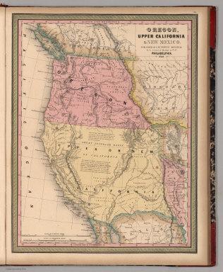
Mitchell, Samuel Augustus
Full Title
Oregon, Upper California & New Mexico. Published By S. Augustus Mitchell. N.E. corner of Market & 7th. Sts. Philadelphia. 1849. Entered ... 1845 by H.N. Burroughs ... Penna.
Publisher
S.A. Mitchell
Author
Mitchell, Samuel Augustus Jr.
Full Title
County map of Arizona and New Mexico. Entered ... 1874, by S. Augustus Mitchell ... Washington.
Publisher
S.A. Mitchell Jr.
Author
Mitchell, Samuel Augustus
Full Title
Map of the State of California, the Territories of Oregon & Utah, and the Chief Part of New Mexico.
Publisher
Thomas, Cowperthwait & Co.
Author
Mitchell, Samuel Augustus
Full Title
A New Map of Nebraska, Kansas, New Mexico and Indian Territories. Published by Charles Desilver, Philadelphia. Entered ... 1856 by Charles Desilver ... Pennsylvania.
Publisher
Charles DeSilver
Author
Mitchell, Samuel Augustus Jr.
Full Title
County map of Arizona and New Mexico. Entered ... 1877 by S. Augustus Mitchell, . ... Washington.
Publisher
S.A. Mitchell Jr.
Author
Mitchell, Samuel Augustus Jr.
Full Title
Arizona and New Mexico. Entered ... 1867 by S. Augustus Mitchell, Jr. ... Pennsylvania.
Publisher
S.A. Mitchell Jr.
Author
Johnson, A.J.
Full Title
Johnson's California, Territories of New Mexico And Utah By Johnson & Browning. No. 47-48.
Publisher
Johnson and Browning
Author
National Map Company
Full Title
Arizona and New Mexico. (Copyrighted by) National Map Company, Indianapolis. (to accompany) Official Paved Road and Commercial Survey of the United States.
Publisher
National Map Company
Author
Mitchell, Samuel Augustus
Full Title
Map of the state of Texas. Engraved to illustrate Mitchell's school and family geography. Entered ... 1846 by S. Augustus Mitchell ... Eastern District of Pennsylvania.
Publisher
Thomas, Cowperthwait & Co.
Author
Touring club italiano
Full Title
Stati Uniti, United States of America, New Mexico, Oklahoma, Texas. (with New Orleans-Mississippi Delta region). Propr. Artistico-letteraria del T.C.I. Ufficio cartografico del T.C.I. (1929)
Publisher
Touring club italiano
Full Title
Main-route and side meanders, and topographical stations (Tortolita and Nogal peaks region, New Mexico). Form 3. U.S. Geographical Surveys West of the 100th Meridian. (1889)
Publisher
U.S.
Author
[United States. Army. Corps of Engineers, Wheeler, G.M.]
Full Title
Sketch of Beaver, Utah showing position of astronomical monument. Sketch of Cheyenne, Wyoming showing position of astronomical monument. Sketch of Fort Union, New Mexico showing position of astronomical monument. Sketch of Georgetown, Colorado showing position of astronomical monument and meridian mark. Sketch of St. George, Utah showing position of astronomical monument. Military reservation, Santa Fe, New Mexico showing position of astronomical monument. Expeditions of 1872, 1873, 1874, 1875 & 1876, under the command of 1st Lieut. Geo. M. Wheeler, Corps of Engineers, U.S. Army. U.S. Geographical Surveys West of the 100th Meridian. George D. Clarke, del. The Graphic Co., N.Y. By order of the honorable the Secretary of War, under the direction of Brig. Gen. A.A. Humphreys, Chief of Engineers, U.S. Army. (1877)
Publisher
U.S.
Full Title
County map of the state of Texas. Showing also portions of the adjoining states and territories. (with) Plan of Galveston and vicinity. Copyright 1887 by Wm. M. Bradley & Bro. (1890)
Publisher
John Y. Huber & Co.
Full Title
County and township map of Arizona and New Mexico. Copyright 1887 by Wm. M. Bradley & Bro. (1890)
Publisher
John Y. Huber & Co.
Author
Mitchell, Samuel Augustus
Full Title
Arizona and New Mexico. Entered ... 1870 by S. Augustus Mitchell, Jr. ... Pennsylvania.
Publisher
[R.A. Campbell, S.A. Mitchell, Jr.]
Author
Mitchell, Samuel Augustus
Full Title
County map of the state of Texas. Showing also portions of the adjoining states and territories. Drawn and engraved by W.H. Gamble, Philadelphia. (with) Plan of Galveston and vicinity. Entered ... 1879 by S. Augustus Mitchell ... Washington. (1880)
Publisher
S.A. Mitchell
|