Who What Where When |
REFINE
Browse All : Historical and Exploration Book of Eastern Europe and ScandinaviaAuthor
Cary, John, ca. 1754-1835
Full Title
A new map of part of the United States of North America, containing those of New York, Vermont, New Hampshire, Massachusets (sic), Connecticut, Rhode Island, Pennsylvania, New Jersey, Delaware, Maryland and Virginia. From the latest authorities. By John Cary, engraver. 1806. London: Published by J. Cary, Engraver & Map-seller, No. 181, Strand, Sept. 1, 1806.
Publisher
John Cary
Author
Cary, John, ca. 1754-1835
Full Title
A new map of part of the United States of North America, containing the Carolinas and Georgia, also the Floridas and part of the Bahama Islands &c. From the latest authorities. By John Cary, engraver. 1806. London: Published by J. Cary, Engraver & Map-seller, No. 181, Strand, Feby. 1st, 1806.
Publisher
John Cary
Author
Vandermaelen, Philippe, 1795-1869
Full Title
Partie des Etats-Unis. Amer. Sep. no. 49. Dressee et dessie. par Ph. Vandermaelen. La lettre par Fois. Charles. Desinee sur pierre et Litie. par H. Ode, Avril 1825. (Quatrieme partie. - Amer. sept. Bruxelles. 1827)
Publisher
Ph. Vandermaelen
Author
Vandermaelen, Philippe, 1795-1869
Full Title
Partie des Etats-Unis. Amer. Sep. no. 50. Dressee et dessinee par Ph. Vandermaelen. La lettre par Ph. Lippens. Desinee sur pierre et Lith. par H. Ode, Mai 1825. (Quatrieme partie. - Amer. sept. Bruxelles. 1827)
Publisher
Ph. Vandermaelen
Author
Vandermaelen, Philippe, 1795-1869
Full Title
Partie des Etats-Unis. Amer. Sep. no. 51. Dressee et dessinee par Ph. Vandermaelen. La lettre par Ph. Lippens. Desinee sur pierre et Lithoge. par H. Ode, Mai 1825. (Quatrieme partie. - Amer. sept. Bruxelles. 1827)
Publisher
Ph. Vandermaelen
Author
Vandermaelen, Philippe, 1795-1869
Full Title
Partie des Etats Unis. Amer. Sep. no. 56. (Dresse par Ph. Vandermaelen, lithographie par H. Ode. Quatrieme partie. - Amer. sept. Bruxelles. 1827)
Publisher
Ph. Vandermaelen
Author
Vandermaelen, Philippe, 1795-1869
Full Title
Partie des Etats Unis. Amer. Sep. no. 57. Dresse et dessinee par Ph. Vandermaelen, lithographie par H. Ode ... 1825. (Quatrieme partie. - Amer. sept. Bruxelles. 1827)
Publisher
Ph. Vandermaelen
Author
Society for the Diffusion of Useful Knowledge (Great Britain)
Full Title
North America sheet VII. Pennsylvania, New Jersey, Maryland, Delaware, Columbia and part of Virginia. Published under the superintendence of the Society for the Diffusion of Useful Knowledge. J. & C. Walker sculpt. Published July 15th. 1833 by Baldwin & Cradock, 47 Paternoster Row, London. Printed by J. & C. Walker. (London: Chapman & Hall, 1844)
Publisher
Chapman and Hall
Author
Society for the Diffusion of Useful Knowledge (Great Britain)
Full Title
North America sheet X. Parts of Missouri, Illinois, Kentucky, Tennessee, Alabama, Mississippi and Arkansas. Published under the superintendence of the Society for the Diffusion of Useful Knowledge. J. & C. Walker sculpt. Published by Baldwin & Cradock, 47 Paternoster Row, 1st. Decr. 1833. (London: Chapman & Hall, 1844)
Publisher
Chapman and Hall
Author
Society for the Diffusion of Useful Knowledge (Great Britain)
Full Title
North America sheet XII. Georgia with parts of North & South Carolina, Tennessee, Alabama & Florida. Published under the superintendence of the Society for the Diffusion of Useful Knowledge. J. & C. Walker sculpt. Published Novr. 1st. 1833 by Baldwin & Cradock, 47 Paternoster Row, London. Printed by Russell, Penge. (London: Chapman & Hall, 1844)
Publisher
Chapman and Hall
Author
Society for the Diffusion of Useful Knowledge (Great Britain)
Full Title
North America sheet XIII. Parts of Louisiana, Arkansas, Mississippi, Alabama & Florida. Published under the superintendence of the Society for the Diffusion of Useful Knowledge. Engraved by J. & C. Walker. Published June 1st. 1833 by Baldwin & Cradock, 47 Paternoster Row, London. (London: Chapman & Hall, 1844)
Publisher
Chapman and Hall
Author
Johnston, Alexander Keith, 1804-1871
Full Title
United States of North America, eastern states, by Keith Johnston, F.R.S.E. Engraved & printed by W. & A.K. Johnston, Edinburgh. William Blackwood & Sons, Edinburgh & London, (1861)
Publisher
William Blackwood & Sons
Author
Bartholomew, John
Full Title
(Index to) U.S.A. South-East. Lambert Conformal Conic Projection, Standard Parallels 33 (degrees) and 45 (degrees) N. 1:2,500,000.
Publisher
[Houghton Mifflin Co., John Bartholomew & Son LTD.]
Author
Bartholomew, John
Full Title
U.S.A. South-East. The Geographical Institute Edinburgh. Edited by John Bartholomew, M.C. LL. D. Copyright - John Bartholomew & Son, LTD. (inset map) New Province.
Publisher
[Houghton Mifflin Co., John Bartholomew & Son LTD.]
Author
Woodbridge, William C.
Full Title
Physical & Political Map Of The Southern Division Of the United States. Adapted To Woodbridge's Geography. Entered .. . 1843, by W.C. Woodbridge ... Massachusetts. Hartford. Published By Wm. Jas. Hamersley. (inset map) Vicinity of Charleston. (inset map) Vicinity of New Orleans.
Publisher
Wm. Jas. Hamersley
Author
[Carey, Mathew, Warner, Benjamin]
Full Title
The Southern States and Mississippi Territory. Philadelphia: Published By M. Carey, And B. Warner. 1816.
Publisher
M. Carey and B. Warner
Author
Woodbridge, William C.
Full Title
Physical & Political Map Of the Southern Division Of The United States. Adapted To Woodbridge's Geography. Entered ... 1843, by W.C. Woodbridge ... Massachusetts. Hartford. Published By Wm. Jas. Hamersley. (to accompany) Modern Atlas, Physical, Political And Statistical; Exhibiting On Separate Maps ... (inset map) Vicinity of Charleston. (inset map) vicinity of New Orleans.
Publisher
Belknap and Hamersley
Author
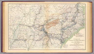
[Duane, James C., United States. War Department]
Full Title
Map showing the operations of the Army of the Potomac under command of Maj. Gen. George G. Meade, from March 29th to April 9th, 1865. J.C. Duane, Major of Engineers ... (with) Map of portions of Mississippi, Alabama and Georgia showing march of Cavalry Corps, Military Division of the Mississippi, from March 22d to April 20th 1865. (with) No. 3. Map showing routes of marches of the army of Gen. W.T. Sherman from Atlanta, Ga. to Goldsborough, N.C. ... (with) Plat showing the battle-ground at Rivers' Bridge, Big Salkehatchie River, S.C. (with) Chart accompanying project for effectually closing Cape Fear River and the port of Wilmington, N.C. to blockade runners. (with) Plans, sections and elevation of pile bridge, James River near Varina, Va., January 1865. W.R. King, 1st Lieut. U.S. Engrs. ... Julius Bien & Co., Lith., N.Y. (1891-1895)
Publisher
U.S. Government Printing Office
Author
Fullarton, A. & Co.
Full Title
United States North America According to Calvin, Smith & Tanner. By G.H. Swanston Edinr. The South Eastern States Comprising Mississippi, Alabama, Tennessee, Georgia, Nth. & Sth. Carolina, and part of Florida, Virginia & Kentucky. LVIII. Engd. by G.H. Swanston Edinburgh. A. Fullarton & Co. Edinburgh, London & Dublin.
Publisher
A. Fullarton & Co.
Full Title
Orchard products. Total value, per square mile of total area ... Rice. Product per square mile of total area. Based on the returns of the tenth census. 1880. Copyright, 1883, by Charles Scribner's Sons.
Publisher
Charles Scribner's Sons
Full Title
Sugar and molasses. Sugar ... Molasses. Product, per square mile of total area. Sugar-cane product. Based on the returns of the tenth census. 1880. Copyright, 1883, by Charles Scribner's Sons.
Publisher
Charles Scribner's Sons
Full Title
Milk. Product per square mile. Sold or sent to butter and cheese factories. ... Butter. Farm product per square mile. Based on the returns of the tenth census. 1880. Copyright, 1883, by Charles Scribner's Sons.
Publisher
Charles Scribner's Sons
Full Title
Cheese. Farm product per square mile. Based on the returns of the tenth census. 1880. Copyright, 1883, by Charles Scribner's Sons.
Publisher
Charles Scribner's Sons
Full Title
American Atlantic ports--south sheet. George Philip & Son, Ltd. The London Geographical Institute. (1922)
Publisher
[C.S. Hammond & Company. London: George Philip & Son, Ltd. The London Geographical Institute, Philip, Son & Nephew, Ltd.]
Author
Melish, John
Full Title
Southern section of the United States including Florida &c. by John Melish. 1816. (Stockholm: Stente af C. Muller, 1824)
Publisher
C. Muller
Author
[Raynal, G.T., Bonne, R.]
Full Title
Le Nouveau Mexique, Avec La Partie Septentrionale De L'Ancien, ou De La Nouvelle Espagne, par M. Bonne, Ingenieur-Hydrographe de la Marine. Grave par Dient. (on upper margin) Liv. VI. et X: No. 28. (on lower margin) 29. (to accompany) Histoire Philosophique et Politique Des Establissements et Du Commerce Des Europeens Dans Les Deux Indes.
Publisher
Jean-Leonard Pellet
Author
[Jenney, William LeB., United States. War Department]
Full Title
Military map of the marches of the United States forces under command of Maj. Gen. W.T. Sherman, U.S.A. during the years 1863, 1864, 1865. Compiled by order of Maj. Gen. W.T. Sherman ... under the direction of Bvt. Maj. W.L.B. Jenney ... Drawn by Capt. William Kossak ... and John B. Muller, draughtsman. St. Louis, Mo., 1865. Julius Bien & Co., Lith., N.Y. (1891-1895)
Publisher
U.S. Government Printing Office
Author
[Ruger, Edward, United States. War Department]
Full Title
Map prepared to exhibit the campaigns in which the Army of the Cumberland took part during the War of the Rebellion. By order of Maj. Gen. Geo. H. Thomas, U.S.A. Compiled under the direction of Bvt. Maj. Gen. Z.B. Tower, Chief Engr., Milit. Div. of the Tenn., by Ed. Ruger ... Assistants: Capt. A. Kilp and Lieut. R. Flach ... (with) Map illustrating the operations of the Seventh Division under Brig. Gen. G.W. Morgan at Cumberland Gap, Tenn., during a portion of the year 1862. Compiled by Edward Ruger ... 1877 (with) Map of the environs of Petersburg, Va., from the Appomattox River to Ft. Howard, showing the positions of the entrenched lines occupied by the Ninth Army Corps, A.P. during the siege. Julius Bien & Co., Lith., N.Y. (1891-1895)
Publisher
U.S. Government Printing Office
Author
[Colton, G.W., United States. War Department]
Full Title
Section of G. Woolworth Colton's new guide map of the United States and Canada with railroads, counties, etc. 1863. Used by General Grant in marking the proposed lines of operations of the armies of the United States, in 1864. Julius Bien & Co., Lith., N.Y. (1891-1895)
Publisher
U.S. Government Printing Office
Author
[Julius Bien & Co., United States. War Department]
Full Title
General topographical map. Sheet I. Julius Bien & Co., Lith., N.Y. (1891-1895)
Publisher
U.S. Government Printing Office
Author
[Julius Bien & Co., United States. War Department]
Full Title
General topographical map. Sheet VII. Julius Bien & Co., Lith., N.Y. (1891-1895)
Publisher
U.S. Government Printing Office
Author
Cornell, S. S. (Sarah S.)
Full Title
Southern and Western States. Designed to accompany Cornell's High school geography. Entered ... 1855, by S.S. Cornell ... Southern District of New York. New York: D. Appleton & Co., 443 & 445 Broadway. (1864)
Publisher
Appleton & Co.
Author
Cornell, S. S. (Sarah S.)
Full Title
Eastern division of the United States. Designed to accompany Cornell's High school geography. Drawn by E. Wells, N.Y. Entered ... 1856, by S.S. Cornell ... Southern District of New York. New York: D. Appleton & Co., 443 & 445 Broadway. (1864)
Publisher
Appleton & Co.
Author
Cornell, S. S. (Sarah S.)
Full Title
Southern division of the United States. Designed to accompany Cornell's High school geography. Drawn by J. Wells, N.Y. Entered ... 1856, by S.S. Cornell ... Southern District of New York. New York: D. Appleton & Co., 443 & 445 Broadway. (1864)
Publisher
Appleton & Co.
Full Title
The Middle States, Maryland & Virginia. J.H. Young Sc. (Philadelphia: John Grigg, No. 9 North Fourth Street. 1830)
Publisher
John Grigg
Author
Thomson, John
Full Title
Southern provinces of the United States. (with view) Characteristic scenery of the Hudson River. Hewitt sc., Grafton Str. East, Tottenham Court Rd. Drawn & engraved for Thomson's New general atlas, 1817.
Publisher
[Baldwin, Cradock, and Joy, John Cumming, John Thomson]
Author
[Huntington, Francis Junius, 1802-1878, Huntington, Hezekiah, 1795-1865]
Full Title
The Middle States, Maryland & Virginia. Entered ... 12th day of August 1830 by H. & F.J. Huntington ... Connecticut.
Publisher
F.J. Huntington
Author
Huntington, Francis Junius, 1802-1878
Full Title
Southern States. Entered ... April 23d, 1832 by F.J. Huntington ... Connecticut.
Publisher
F.J. Huntington
Author
Letts, Son & Co.
Full Title
Eastern United States. No. 8. Letts's popular atlas. Letts, Son & Co. Limited, London. (1883)
Publisher
Letts, Son & Co.
Author
Robert Laurie & James Whittle
Full Title
A new and general map of the southern dominions belonging to the United States of America, viz: North Carolina, South Carolina, and Georgia: with the bordering Indian countries, and the Spanish possessions of Louisiana and Florida. (with) Plan of Charlestown. (with) Plan of St. Augustine. London, Published by Laurie & Whittle, No. 53, Fleet Street, as the act directs 12th May, 1794.
Publisher
Laurie & Whittle
Full Title
Middle States. Entered according to act of Congress. (1837)
Publisher
Robinson, Pratt & Co.
Full Title
Southern States. Entered according to act of Congress. (1837)
Publisher
Robinson, Pratt & Co.
Author
Goodrich, S.G.
Full Title
Middle States. Southern States. G. Boynton Sc. Entered ... by S.G. Goodrich of Massachusetts. (Boston: Gray & Bowen ... 1831)
Publisher
Gray & Bowen
Author
Mitchell, Samuel Augustus
Full Title
Map of the Middle States and part of the southern. Engraved to illustrate Mitchell's school and family geography. Entered ... 1839 by S. Augustus Mitchell ... Connecticut.
Publisher
Thomas, Cowperthwait & Co.
Author
Mitchell, Samuel Augustus
Full Title
Map of the chief part of the Southern States and part of the western. Engraved to illustrate Mitchell's school and family geography. Engraved by W. Williams. Entered ... 1839 by S. Augustus Mitchell ... Connecticut.
Publisher
Thomas, Cowperthwait & Co.
Author
Touring club italiano
Full Title
Stati Uniti, United States of America, Arkansas, Tennessee, Louisiana, Mississippi, Florida, Alabama, Georgia, South Carolina. Propr. Artistico-letteraria del T.C.I. Ufficio cartografico del T.C.I. (1929)
Publisher
Touring club italiano
Author
Gannett, Henry, 1846-1914
Full Title
Sketch map showing the position of the center of the Negro population and the median point in 1880, 1890 and 1900. Compiled by Henry Gannett, Geographer. (United States Census Office, 1903). Julius Bien & Co., N.Y.
Publisher
U.S. Census Office
Author
Melish, John
Full Title
Southern Section of the United States including Florida &c. by John Melish. Entered ... by John Melish ... 1 March 1813.
Publisher
John Melish
Author
Stieler, Adolf
Full Title
Vereinigte Staaten Von Nord-Amerika In 6 Blattern, Bl. 5. Petermann. Bearbeitet v. H. Habenicht. Gest v. Metzeroth, Eberhardt, Kuhn & Kramer. Gotha: Justus Perthes. 1872.
Publisher
Justus Perthes
Author
Stieler, Adolf
Full Title
Vereinigte Staaten Von Nord-Amerika In 6 Blattern, Bl. 6. Petermann. Bearbeitet v. H. Habenicht. Gest v. Eberhardt, Kuhn, Metzeroth u. Weiler. Gotha: Justus Perthes. 1873.
Publisher
Justus Perthes
|