Who What Where WhenREMOVE |
Author
World Meteorological Organization (WMO)
Full Title
Average Amount of Precipitation mm, June.
Publisher
WMO, Unesco, Cartographia
Author
World Meteorological Organization (WMO)
Full Title
Average Amount of Precipitation mm, July.
Publisher
WMO, Unesco, Cartographia
Author
[Everts & Co., L.H. Everts & Co.]
Full Title
Sabetha, ... Nemaha Co., Kan. (with) Centralia ... (with) Taylor Rapids ... (both) Nemaha Co. (L.H. Everts & Co., publishers, Phila., Pa., 1887)
Publisher
L.H. Everts & Co.
Author
World Meteorological Organization (WMO)
Full Title
Average Amount of Precipitation mm, August.
Publisher
WMO, Unesco, Cartographia
Author
World Meteorological Organization (WMO)
Full Title
Average Amount of Precipitation mm, September.
Publisher
WMO, Unesco, Cartographia
Author
World Meteorological Organization (WMO)
Full Title
Average Amount of Precipitation mm, October.
Publisher
WMO, Unesco, Cartographia
Author
World Meteorological Organization (WMO)
Full Title
Average Amount of Precipitation mm, November.
Publisher
WMO, Unesco, Cartographia
Author
World Meteorological Organization (WMO)
Full Title
Average Amount of Precipitation mm, December.
Publisher
WMO, Unesco, Cartographia
Author
World Meteorological Organization (WMO)
Full Title
Meteorological Stations Used for the Preparation of Climatic Maps.
Publisher
WMO, Unesco, Cartographia
Author
World Meteorological Organization (WMO)
Full Title
Average Amount of Precipitation mm, Year (Part 1).
Publisher
WMO, Unesco, Cartographia
Author
World Meteorological Organization (WMO)
Full Title
Average Amount of Precipitation mm, Year (Part 2).
Publisher
WMO, Unesco, Cartographia
Author
World Meteorological Organization (WMO)
Full Title
Average Amount of Precipitation mm, Year (Part 3).
Publisher
WMO, Unesco, Cartographia
Author
[Everts & Co., L.H. Everts & Co.]
Full Title
Seneca, Nemaha County. (with) Oneida ... (with) Goffs ... (with) Baileyville ... (all) Nemaha Co. (L.H. Everts & Co., publishers, Phila., Pa., 1887)
Publisher
L.H. Everts & Co.
Author
[Allen, C. R., Everts & Co., L.H. Everts & Co.]
Full Title
Nemaha Co., Kansas. (with) Wetmore .... (with) Corning ... L.H. Everts & Co., publishers, Phila., Pa. (1887)
Publisher
L.H. Everts & Co.
Author
[U.S. Northern Boundary Commission, Campbell, Archibald, Twining, W.J.]
Full Title
United States Northern Boundary Commission, Map of the Vicinity of the North West Point of the Lake of the Woods.
Publisher
Government Printing Office
Author
[Everts & Co., L.H. Everts & Co.]
Full Title
Reece ... (with) Fall River ... (with) Hamilton ... (with) Neal ... (with) Climax ... (all) Greenwood Co. (L.H. Everts & Co., publishers, Phila., Pa., 1887)
Publisher
L.H. Everts & Co.
Author
[U.S. Northern Boundary Commission, Campbell, Archibald, Twining, W.J.]
Full Title
Sketch Showing Triangulation of Chief Mountain Lake.
Publisher
Government Printing Office
Author
[U.S. Northern Boundary Commission, Campbell, Archibald, Twining, W.J.]
Full Title
General Authority U.S. Coast Survey Chart 1875. Declinations along 49th Parallel....
Publisher
Government Printing Office
Author
[U.S. Northern Boundary Commission, Campbell, Archibald, Twining, W.J.]
Full Title
Profile. Reconnaissance Series. (Lake of the Woods to Rocky Mountain Divide).
Publisher
Government Printing Office
Author
[U.S. Northern Boundary Commission, Campbell, Archibald, Twining, W.J.]
Full Title
United States Northern Boundary Commission. No. I, Reconnaissance Map. Archibald Campbell Esq., Commissioner. Reconnaissance Maps (Six Sheets and Profile) ... 49th Parallel from the Lake of the Woods to the Rocky Mountains. (Fort Shaw to Rocky Mountain Divide).
Publisher
Government Printing Office
Author
[U.S. Northern Boundary Commission, Campbell, Archibald, Twining, W.J.]
Full Title
United States Northern Boundary Commission. No. II, Reconnaissance Map ... 49th Parallel. (Old Fort Browning to Sweet Grass Hills).
Publisher
Government Printing Office
Author
[U.S. Northern Boundary Commission, Campbell, Archibald, Twining, W.J.]
Full Title
United States Northern Boundary Commission. No. III, Reconnaissance Map ... 49th Parallel. (Big Muddy River to Fort Hawley).
Publisher
Government Printing Office
Author
[U.S. Northern Boundary Commission, Campbell, Archibald, Twining, W.J.]
Full Title
United States Northern Boundary Commission. No. IV, Reconnaissance Map ... 49th Parallel. (Mouse River to Fort Buford).
Publisher
Government Printing Office
Author
[U.S. Northern Boundary Commission, Campbell, Archibald, Twining, W.J.]
Full Title
United States Northern Boundary Commission. No. V, Reconnaissance Map ... 49th Parallel. (Pembina Mountains to Mouse River).
Publisher
Government Printing Office
Author
[U.S. Northern Boundary Commission, Campbell, Archibald, Twining, W.J.]
Full Title
United States Northern Boundary Commission. No. VI, Reconnaissance Map ... 49th Parallel. (Lake of the Woods to Ft. Pembina).
Publisher
Government Printing Office
Author
[Everts & Co., L.H. Everts & Co.]
Full Title
Madison ... Greenwood Co. (with) Waverly, Coffee Co. (with) Bacheller, Davis Co., Milford P.O. (with) New Milford, Acme P.O., Davis Co. (L.H. Everts & Co., publishers, Phila., Pa., 1887)
Publisher
L.H. Everts & Co.
Author
[Everts & Co., L.H. Everts & Co.]
Full Title
Davis Co., Kansas. L.H. Everts & Co., publishers, Phila., Pa. (1887)
Publisher
L.H. Everts & Co.
Author
Mitchell, Samuel Augustus Jr.
Full Title
The World in Hemispheres. With others Projections &c.&c. Constructed & Engraved by W. Williams Philadelphia. Entered ... 1860, by S. Augustus Mitchell, Jr. ... Pennsylvania. (insets) North Polar Region. The World on a Polar Projection. Land and Water Hemispheres.
Publisher
S.A. Mitchell Jr.
Author
Mitchell, Samuel Augustus Jr.
Full Title
Map of the World in Mercator projection. Exhibiting the American Continents as its center. Entered ... 1864 by S. Augustus Mitchell, Jr. ... Pennsylvania.
Publisher
S.A. Mitchell Jr.
Author
Mitchell, Samuel Augustus Jr.
Full Title
Map of North America. Showing its political divisions, and recent discoveries in the Polar Regions. Constructed & Engraved by W. Williams Philadelphia. Entered ... 1860 by S. Augustus Mitchell, Jr. ... Pennsylvania.
Publisher
S.A. Mitchell Jr.
Author
Mitchell, Samuel Augustus Jr.
Full Title
County map of Nova Scotia, New Brounswick, Cape Breton Id. and Pr. Edward's Id. Entered ... 1860 by S. Augustus Mitchell, Jr. ... Pennsylvania. (inset map) 5. City and Harbor of Halifax.
Publisher
S.A. Mitchell Jr.
Author
[Everts & Co., L.H. Everts & Co.]
Full Title
Neosho Co., Kansas. L.H. Everts & Co., publishers, Phila., Pa. (1887)
Publisher
L.H. Everts & Co.
Author
Mitchell, Samuel Augustus Jr.
Full Title
Map of Canada East in Counties. Entered ... 1860 by S. Augustus Mitchell, Jr. ... Pennsylvania. (inset map) 7. Environs of Montreal.
Publisher
S.A. Mitchell Jr.
Author
Mitchell, Samuel Augustus Jr.
Full Title
Map of Canada West in Counties. Entered ... 1860 by S. Augustus Mitchell, Jr. ... Pennsylvania.
Publisher
S.A. Mitchell Jr.
Author
Mitchell, Samuel Augustus Jr.
Full Title
Map of the United States, and Territories. together with Canada &c. Constructed & Engraved by W. Williams Philadelphia. Entered ... 1860 by S. Augustus Mitchell, Jr. ... Pennsylvania. (inset map) Island of Newfoundland.
Publisher
S.A. Mitchell Jr.
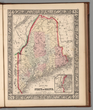
Author
Mitchell, Samuel Augustus Jr.
Full Title
County map of the State of Maine. Entered ... 1860 by S. Augustus Mitchell, Jr. ... Pennsylvania. (inset map) 13. Portland Har. and Vicinity.
Publisher
S.A. Mitchell Jr.
Author
[Everts & Co., L.H. Everts & Co.]
Full Title
Chanute ... (with) Shaw ... (with) Morehead ... (all) Neosho Co. (L.H. Everts & Co., publishers, Phila., Pa., 1887)
Publisher
L.H. Everts & Co.
Author
Mitchell, Samuel Augustus Jr.
Full Title
New Hampshire and Vermont. Drawn and Eng. by W.H. Gamble. Entered ... 1862 by S. Augustus Mitchell, Jr. ... Pennsylvania.
Publisher
S.A. Mitchell Jr.
Author
Mitchell, Samuel Augustus Jr.
Full Title
County map of Massachusetts, Connecticut, and Rhode Island. Drawn & Engraved by W.H. Gamble Philad. Entered ... 1862 by S. Augustus Mitchell, Jr. ... Pennsylvania.
Publisher
S.A. Mitchell Jr.
Author
Mitchell, Samuel Augustus Jr.
Full Title
County map of the State of New York, New Hampshire, Vermont. Massachusetts, Rhode Id. and Connecticut. Drawn & Engraved by W. Williams Philadelphia. Entered ... 1860 by S. Augustus Mitchell, Jr. ... Pennsylvania. (inset maps)17. Harbor and Vicinity of New York, and 18. Harbor and Vicinity of Boston.
Publisher
S.A. Mitchell Jr.
Author
Mitchell, Samuel Augustus Jr.
Full Title
Plan of New York &c. Entered ... 1860 by S. Augustus Mitchell, Jr. ... Pennsylvania.
Publisher
S.A. Mitchell Jr.
Author
Mitchell, Samuel Augustus Jr.
Full Title
Plan of Boston. Entered ... 1860 by S. Augustus Mitchell, Jr. ... Pennsylvania. (inset map) Map of the Country arond Boston showing also its Harbor & Islands.
Publisher
S.A. Mitchell Jr.
Author
Mitchell, Samuel Augustus Jr.
Full Title
County map of the State of Pennsylvania. Drawn & Engraved by W.H. Gamble Philadelphia. Entered ... 1865 by S. Augustus Mitchell, Jr. ... Pennsylvania.
Publisher
S.A. Mitchell Jr.
Author
Mitchell, Samuel Augustus Jr.
Full Title
Plan of Philadelphia. Entered ... 1865 by S. Augustus Mitchell, Jr. ... Pennsylvania.
Publisher
S.A. Mitchell Jr.
Author
Mitchell, Samuel Augustus Jr.
Full Title
County map of New Jersey. (Scale: 1:1,100,000). County map of Maryland and Delaware. Drawn & Engraved by W.H. Gamble Philadelphia. (Scale: 1,550,000). Entered ... 1865 by S. Augustus Mitchell, Jr. ... Pennsylvania.
Publisher
S.A. Mitchell Jr.
Author
Mitchell, Samuel Augustus Jr.
Full Title
Plan of Baltimore. Entered ... 1860 by S. Augustus Mitchell, Jr. ... Pennsylvania.
Publisher
S.A. Mitchell Jr.
Author
Mitchell, Samuel Augustus Jr.
Full Title
Plan of the City of Washington. The Capital of the United States of America. Drawn & Engraved by W.H. Gamble. Entered ... 1861 by S. Augustus Mitchell, Jr. ... Pennsylvania.
Publisher
S.A. Mitchell Jr.
Author
Mitchell, Samuel Augustus Jr.
Full Title
County map of Virginia and West Virginia. Drawn & Engd. by W.H. Gamble Phila. Entered ... 1863 by S. Augustus Mitchell, Jr. ... Pennsylvania.
Publisher
S.A. Mitchell Jr.
Author
[Everts & Co., L.H. Everts & Co.]
Full Title
Osage Mission ... (with) Galesburg ... (with) Earlton ... (all) Neosho Co. (L.H. Everts & Co., publishers, Phila., Pa., 1887)
Publisher
L.H. Everts & Co.
|