Who What Where WhenREMOVE |
Author
Jacotin, Pierre, 1765-1827
Full Title
(Carte topographique de l'Egypte et de plusieurs parties des pays limitrophes ...) Flle. 6. Vallee de Qoseir. Leve par M. Schouani. Jacotin dirt. [1826]
Publisher
C.L.F. Panckoucke
Author
Mitchell, Samuel Augustus Jr.
Full Title
Western Hemisphere. Eastern Hemisphere. Entered ... 1876 by S. Augustus Mitchell, . ... Washington. (insets): Northern Hemisphere. Southern Hemisphere. Greatest Mass of Water. Greatest Mass of Land. Levels of the sea.
Publisher
S.A. Mitchell Jr.
Author
Mitchell, Samuel Augustus Jr.
Full Title
Map of the World on Mercator Projection, Exhibiting the American Continent as its Centre. Entered ... 1876 by S. Augustus Mitchell, . ... Washington.
Publisher
S.A. Mitchell Jr.
Author
Jacotin, Pierre, 1765-1827
Full Title
(Carte topographique de l'Egypte et de plusieurs parties des pays limitrophes ...) Flle. 7. Qoseir. Leve par M. Dubois-Ayme, Schouani et Legentil. Jacotin dirt. [1826]
Publisher
C.L.F. Panckoucke
Author
Mitchell, Samuel Augustus Jr.
Full Title
Map of North America. Showing its Political Divisions, and recent discoveries in the Polar Regions. Constructed and Engraved by W. Williams, Philadelphia. Entered ... 1876 by S. Augustus Mitchell, . ... Washington.
Publisher
S.A. Mitchell Jr.
Author
Mitchell, Samuel Augustus Jr.
Full Title
County map of Nova Scotia, New Brunswick, Cape Breton Id. and Pr. Edward's Id. Entered ... 1877 by S. Augustus Mitchell, . ... Washington. (inset map): City and Harbor of Halifax.
Publisher
S.A. Mitchell Jr.
Author
Mitchell, Samuel Augustus Jr.
Full Title
Map of Quebec in Counties. Entered ... 1877 by S. Augustus Mitchell, . ... Washington. (inset map): Environs of Montreal.
Publisher
S.A. Mitchell Jr.
Author
Mitchell, Samuel Augustus Jr.
Full Title
Map of Ontario in Counties. Entered ... 1877 by S. Augustus Mitchell, . ... Washington. (inset map) Environs of Montreal.
Publisher
S.A. Mitchell Jr.
Author
Jacotin, Pierre, 1765-1827
Full Title
(Carte topographique de l'Egypte et de plusieurs parties des pays limitrophes ...) Flle. 8. El Haweh. Leve par M. Schouani. Jacotin dirt. [1826]
Publisher
C.L.F. Panckoucke
Author
Mitchell, Samuel Augustus Jr.
Full Title
Map of the Original Thirteen Colonies. Copied from John Mitchell's Map of the British & French Dominions. Entered ... 1877 by S. Augustus Mitchell, . ... Washington.
Publisher
S.A. Mitchell Jr.
Author
Mitchell, Samuel Augustus Jr.
Full Title
Map of the United States, and Territories. together with Canada &c. Constructed & Engraved by W. Williams Philadelphia. (with inset map): Island Of Newfoundland. Entered ... 1876 by S. Augustus Mitchell, . ... Washington.
Publisher
S.A. Mitchell Jr.
Author
Mitchell, Samuel Augustus Jr.
Full Title
County map of the State of Maine. (with inset map) Fortland Har. and Vicinity. Entered ... 1876 by S. Augustus Mitchell, . ... Washington.
Publisher
S.A. Mitchell Jr.
Author
Mitchell, Samuel Augustus Jr.
Full Title
County and township map of the States of New Hampshire and Vermont. Entered ... 1877 by S. Augustus Mitchell, . ... Washington.
Publisher
S.A. Mitchell Jr.
Author
Mitchell, Samuel Augustus Jr.
Full Title
County and township map of the States of Massachusetts, Connecticut and Rhode Island. Drawn and Engraved by W.H. Gamble Philadelphia. Entered ... 1876 by S. Augustus Mitchell, . ... Washington.
Publisher
S.A. Mitchell Jr.
Author
Jacotin, Pierre, 1765-1827
Full Title
(Carte topographique de l'Egypte et de plusieurs parties des pays limitrophes ...) Flle. 9. Qeneh. Leve par M. Schouani. Jacotin dirt. [1826]
Publisher
C.L.F. Panckoucke
Author
Mitchell, Samuel Augustus Jr.
Full Title
Plan of Boston. Entered ... 1877 by S. Augustus Mitchell, . ... Washington. (with untitled inset map of): Boston Harbor.
Publisher
S.A. Mitchell Jr.
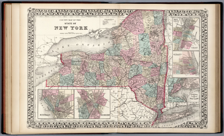
Author
Mitchell, Samuel Augustus Jr.
Full Title
County map of the State of New York. Drawn and Engraved by W.H. Gamble Philadelphia. Entered ... 1876 by S. Augustus Mitchell, . ... Washington. (with inset maps) Buffalo. Rochester. West Troy, Troy. Albany. Harbor and vicinity of New York.
Publisher
S.A. Mitchell Jr.
Author
Mitchell, Samuel Augustus Jr.
Full Title
New York and Brooklyn. Entered ... 1876 by S. Augustus Mitchell, . ... Washington. (inset map): Northern portion of New York City and County.
Publisher
S.A. Mitchell Jr.
Author
Jacotin, Pierre, 1765-1827
Full Title
(Carte topographique de l'Egypte et de plusieurs parties des pays limitrophes ...) Flle. 10. Girgeh. Leve par M. Schouani. Jacotin dirt. [1826]
Publisher
C.L.F. Panckoucke
Author
Mitchell, Samuel Augustus Jr.
Full Title
County map of the State of Pennsylvania. Drawn and Engraved by W.H. Gamble Philadelphia. Entered ... 1876 by S. Augustus Mitchell, . ... Washington. (with four inset maps): Harrisburg, Williamsport, Erie, and Scranton.
Publisher
S.A. Mitchell Jr.
Author
Mitchell, Samuel Augustus Jr.
Full Title
Plan of the City of Philadelphia and Camden, 1876. Drawn and Engraved by W.H. Gamble Philadelphia. Entered ... 1876 by S. Augustus Mitchell, . ... Washington.
Publisher
S.A. Mitchell Jr.
Author
Mitchell, Samuel Augustus Jr.
Full Title
County map of New Jersey. Scale 1:1,100,000. County map of Maryland and Delaware. Scale 1:1,400,000. Drawn and engraved by W.H. Gamble, Philadelphia. Entered ... 1877 by S. Augustus Mitchell, . ... Washington.
Publisher
S.A. Mitchell Jr.
Author
Jacotin, Pierre, 1765-1827
Full Title
(Carte topographique de l'Egypte et de plusieurs parties des pays limitrophes ...) Flle. 11. Tahtah. Leve par M.M. Bertre, Lecesne et Schouani. Jacotin dirt. [1826]
Publisher
C.L.F. Panckoucke
Author
Mitchell, Samuel Augustus Jr.
Full Title
County map of Virginia and West Virginia. Drawn & Engd. by W.H. Gamble, Philad. Entered ... 1877 by S. Augustus Mitchell, . ... Washington.
Publisher
S.A. Mitchell Jr.
Author
Mitchell, Samuel Augustus Jr.
Full Title
Plan of Baltimore. Entered ... 1877 by S. Augustus Mitchell, . ... Washington.
Publisher
S.A. Mitchell Jr.
Author
Mitchell, Samuel Augustus Jr.
Full Title
Plan of the city of Washington. The capitol of the United States of America. Entered ... 1877 by S. Augustus Mitchell, . ... Washington.
Publisher
S.A. Mitchell Jr.
Author
Mitchell, Samuel Augustus Jr.
Full Title
Kentucky and Tennessee.
Publisher
S.A. Mitchell Jr.
Author
Jacotin, Pierre, 1765-1827
Full Title
(Carte topographique de l'Egypte et de plusieurs parties des pays limitrophes ...) Flle. 12. Siout. Leve par M.M. Bertre, Lecesne et Schouani. Jacotin dirt. [1826]
Publisher
C.L.F. Panckoucke
Author
Mitchell, Samuel Augustus Jr.
Full Title
County map of the States of Georgia and Alabama. Entered ... 1876 by S. Augustus Mitchell, . ... Washington. (inset maps): Savannah Georgia. (with reference to squares), and City of Atlanta, the capital of Georgia.
Publisher
S.A. Mitchell Jr.
Author
Mitchell, Samuel Augustus Jr.
Full Title
North and South Dakota. Entered ... 1877 by S. Augustus Mitchell, . ... Washington. (inset map): Plan of Charleston.
Publisher
S.A. Mitchell Jr.
Author
Mitchell, Samuel Augustus Jr.
Full Title
County map of Florida. Entered ... 1876 by S. Augustus Mitchell, . ... Washington. (inset map): Mobile.
Publisher
S.A. Mitchell Jr.
Author
Mitchell, Samuel Augustus Jr.
Full Title
County map of the States of Arkansas, Mississippi, and Louisiana. Drawn and engraved by W.H. Gamble Philadelphia. Entered ... 1876 by S. Augustus Mitchell, . ... Washington. (inset map): Mobile.
Publisher
S.A. Mitchell Jr.
Author
Jacotin, Pierre, 1765-1827
Full Title
(Carte topographique de l'Egypte et de plusieurs parties des pays limitrophes ...) Flle. 13. Manfalout. Leve par M.M. Jomard, Bertre, Lecesne et Raffenau Delile. Jacotin dirt. [1826]
Publisher
C.L.F. Panckoucke
Author
Bowen, Emanuel
Full Title
A circle of winds consisting of 32 points commonly called the mariners compass. The artificial sphere. (By Emanuel Bowen. London: Printed for William Innys, Richard Ware, Aaron Ward, J. and P. Knapton, John Clarke, T. Longman and T. Shewell, Thomas Osborne, Henry Whitridge ... M.DCC.XLVII)
Publisher
William Innys [et al.]
Author
Mitchell, Samuel Augustus Jr.
Full Title
Plan of New Orleans. Entered ... 1876 by S. Augustus Mitchell, . ... Washington.
Publisher
S.A. Mitchell Jr.
Author
Mitchell, Samuel Augustus Jr.
Full Title
County map of the State of Texas: showing also portion of the adjoining States and Territories. Drawn and engraved by W.H. Gamble Philadelphia. Entered ... 1876 by S. Augustus Mitchell, . ... Washington. (inset map): Plan of Galveston and vicinity.
Publisher
S.A. Mitchell Jr.
Author
Mitchell, Samuel Augustus Jr.
Full Title
County map of Ohio and Indiana. Drawn and engraved by W.H. Gamble Philada. Entered ... 1877 by S. Augustus Mitchell, . ... Washington.
Publisher
S.A. Mitchell Jr.
Author
Mitchell, Samuel Augustus Jr.
Full Title
Plan of Cincinnati and vicinity. Entered ... 1876 by S. Augustus Mitchell, . ... Washington.
Publisher
S.A. Mitchell Jr.
Author
Jacotin, Pierre, 1765-1827
Full Title
(Carte topographique de l'Egypte et de plusieurs parties des pays limitrophes ...) Flle. 14. Miniet, Antinoe. Leve par M. Jomard. Jacotin dirt. [1826]
Publisher
C.L.F. Panckoucke
Author
Mitchell, Samuel Augustus Jr.
Full Title
County and township map of the State of Illinois. Entered ... 1877 by S. Augustus Mitchell, . ... Washington. (inset map): Vicinity of Springfield.
Publisher
S.A. Mitchell Jr.
Author
Mitchell, Samuel Augustus Jr.
Full Title
Chicago. Entered ... 1876 by S. Augustus Mitchell, . ... Washington.
Publisher
S.A. Mitchell Jr.
Author
Mitchell, Samuel Augustus Jr.
Full Title
St. Louis. Entered ... 1876 by S. Augustus Mitchell, . ... Washington.
Publisher
S.A. Mitchell Jr.
Author
Mitchell, Samuel Augustus Jr.
Full Title
County and township map of the States of Iowa and Missouri. Drawn and engraved by W.H. Gamble Philadelphia. Entered ... 1876 by S. Augustus Mitchell, . ... Washington.
Publisher
S.A. Mitchell Jr.
Author
Mitchell, Samuel Augustus Jr.
Full Title
Plan of Milwaukee. Entered ... 1877 by S. Augustus Mitchell, . ... Washington.
Publisher
S.A. Mitchell Jr.
Author
Upper Peninsula Development Bureau
Full Title
Copper Country - Keweenaw Land. Gateway to Isle Royale.
Publisher
Upper Peninsula Development Bureau
Author
Vandermaelen, Philippe, 1795-1869
Full Title
Partie de la Russie d'Europe. Europe no. 6. (Dresse par Ph. Vandermaelen, lithographie par H. Ode. Premier partie. - Europe. Bruxelles. 1827)
Publisher
Ph. Vandermaelen
Author
Upper Peninsula Development Bureau
Full Title
Keweenaw County.
Publisher
Upper Peninsula Development Bureau
Author
Upper Peninsula Development Bureau
Full Title
Ontonagon County.
Publisher
Upper Peninsula Development Bureau
Author
Upper Peninsula Development Bureau
Full Title
Gogebic County.
Publisher
Upper Peninsula Development Bureau
|