|
REFINE
Browse All : View and County Atlas by William Frederick AustinAuthor
[U.S. Geological Survey, Alpha, Tau Rho, Morley, James M., Austin, William A.]
Full Title
Oblique Map of the Republic of Vanuatu, Southwest Pacific.
Publisher
U.S. Geological Survey
Author
[U.S. Geological Survey, Alpha, Tau Rho]
Full Title
Bahia de Compeche.
Publisher
U.S. Geological Survey
Author
[U.S. Geological Survey, Alpha, Tau Rho]
Full Title
British Honduras.
Publisher
U.S. Geological Survey
Author
[U.S. Geological Survey, Alpha, Tau Rho]
Full Title
Caribbean Arc-Hispaniola to Guadeloupe.
Publisher
U.S. Geological Survey
Author
[U.S. Geological Survey, Alpha, Tau Rho]
Full Title
Northeast Caribbean Sea.
Publisher
U.S. Geological Survey
Author
[U.S. Geological Survey, Alpha, Tau Rho, Maher, J.C.]
Full Title
Physiographic Diagram of the Gulf of Mexico.
Publisher
U.S. Geological Survey
Author
[U.S. Geological Survey, Alpha, Tau Rho]
Full Title
Venezuelan Borderlands.
Publisher
U.S. Geological Survey
Author
[U.S. Geological Survey, Alpha, Tau Rho]
Full Title
Almeria, Espana.
Publisher
U.S. Geological Survey
Author
[U.S. Geological Survey, Alpha, Tau Rho, Maher, J.A.]
Full Title
Physiographic Diagram of Atlantic Coastal Plain and Continental Shelf of North America.
Publisher
U.S. Geological Survey
Author
[U.S. Geological Survey, Alpha, Tau Rho]
Full Title
Oblique Map of the Atlantic Continental Margin of North America.
Publisher
U.S. Geological Survey
Author
[U.S. Geological Survey, Alpha, Tau Rho, Maher, John C.]
Full Title
Physiographic Diagram of Bahama Banks, Bahamas.
Publisher
U.S. Geological Survey
Author
[U.S. Geological Survey, Alpha, Tau Rho, Dillon, William P., Forrestel, Patricia, Zwinakis, Jeff]
Full Title
Physiographic Diagram of the Blake Escarpment Off Southeastern United States.
Publisher
U.S. Geological Survey
Author
[U.S. Geological Survey, Alpha, Tau Rho]
Full Title
Oblique Map of the Crest of the East Pacific Rise near the Mouth of the Gulf of California.
Publisher
U.S. Geological Survey
Author
[U.S. Geological Survey, Alpha, Tau Rho]
Full Title
Oblique Map of the Falkland Plateau Region.
Publisher
U.S. Geological Survey
Author
[U.S. Geological Survey, Alpha, Tau Rho]
Full Title
Oblique Map of the May 31, 1970, Debris Avalanche, Huascaran Mountain, Peru.
Publisher
U.S. Geological Survey
Author
[U.S. Geological Survey, Alpha, Tau Rho]
Full Title
Hudson Canyon, North Atlantic Ocean.
Publisher
U.S. Geological Survey
Author
[U.S. Geological Survey, Alpha, Tau Rho]
Full Title
Mid-Atlantic Ridge at Latitude 38°48' North, North Atlantic Ocean.
Publisher
U.S. Geological Survey
Author
[U.S. Geological Survey, Alpha, Tau Rho]
Full Title
Schematic Block Diagram of the Head of the Rio Balsas Canyon, Canon de la Necesidad, Mexico.
Publisher
U.S. Geological Survey
Author
[U.S. Geological Survey, Alpha, Tau Rho]
Full Title
Oblique Map of the Ross Sea Continental Shelf, Antarctica.
Publisher
U.S. Geological Survey
Author
[U.S. Geological Survey, Alpha, Tau Rho]
Full Title
Upper Verde River, Arizona.
Publisher
U.S. Geological Survey
Author
[U.S. Geological Survey, Alpha, Tau Rho]
Full Title
Glacial Erosion.
Publisher
U.S. Geological Survey
Author
[U.S. Geological Survey, Alpha, Tau Rho]
Full Title
Development of the Southern Moroccan Continental Shelf.
Publisher
U.S. Geological Survey
Author
[U.S. Geological Survey, Alpha, Tau Rho, Reimnitz, Erk, Barnes, P.W.]
Full Title
Sea Ice and Submarine Topography.
Publisher
U.S. Geological Survey
Author
[U.S. Geological Survey, Alpha, Tau Rho, Reimnitz, Erk, Toimil, Larry]
Full Title
Sea-Ice Zonation in Relation to Bottom Morphology, Beaufort Sea, Alaska.
Publisher
U.S. Geological Survey
Author
[U.S. Geological Survey, Alpha, Tau Rho]
Full Title
Relation of Ore Bodies to Surface of Tintic Quartzite, East Tintic District, Utah
Publisher
U.S. Geological Survey
Author
[U.S. Geological Survey, Alpha, Tau Rho, Greene, H. Gary]
Full Title
Selective Types of Impulsive Wave Generation.
Publisher
U.S. Geological Survey
Author
[U.S. Geological Survey, Alpha, Tau Rho, Greene, H. Gary]
Full Title
Selective Types of Impulsive Wave Generation - Continued.
Publisher
U.S. Geological Survey
Author
Black, Adam & Charles
Full Title
Australasia. Edinburgh, published by A. and C. Black. Engraved by Sidney Hall. (to accompany) Atlas of Australia with all the Gold Regions.
Publisher
Adam & Charles Black
Author
Black, Adam & Charles
Full Title
Australia. Edinburgh, published by A. and C. Black. Constructed and engraved by J. Bartholomew, Edinr.. (inset) Van Diemen's Land.
Publisher
Adam & Charles Black
Author
Stieler, Adolf
Full Title
Indien & Inner-Asien, Nordliches Blatt. A. Petermann. Bearbeitet von E. Debes & H. Habenicht. Druck v. Hellfarth in Gotha. Gotha: Justus Perthes 1875.
Publisher
Justus Perthes
Author
Black, Adam & Charles
Full Title
Victoria, New South Wales and South Australia. Edinburgh, published by A. and C. Black. (Engraved by) W. Hughes. (inset) Norfolk Island.
Publisher
Adam & Charles Black
Author
Black, Adam & Charles
Full Title
New South Wales. Edinburgh, published by A. and C. Black. Drawn & engd. by J. Bartholomew, Edinr. (inset) Plan of Sidney.
Publisher
Adam & Charles Black
Author
Black, Adam & Charles
Full Title
Victoria. Edinburgh, published by A. and C. Black. Drawn & engd. by J. Bartholomew, Edinr. (inset) Mount Alexander Gold Region.
Publisher
Adam & Charles Black
Author
Black, Adam & Charles
Full Title
New Zealand. By W. Hughes. Edinburgh, published by A. and C. Black. (Engreved by) W. Hughes. (insets) The settled portion of Western Australia ; Van Diemens Land.
Publisher
Adam & Charles Black
Author
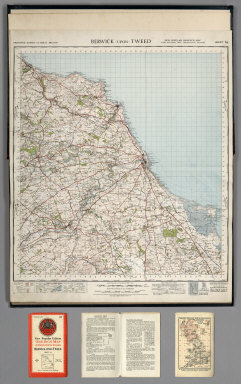
Great Britain. Ordnance Survey
Full Title
Sheet 64. Berwick-upon-Tweed.
Publisher
Ordnance Survey of Great Britain
Author
Great Britain. Ordnance Survey
Full Title
Sheet 71. Alnwick.
Publisher
Ordnance Survey of Great Britain
Author
Great Britain. Ordnance Survey
Full Title
Sheet 75. Dumfries.
Publisher
Ordnance Survey of Great Britain
Author
Great Britain. Ordnance Survey
Full Title
Sheet 76. Carlisle.
Publisher
Ordnance Survey of Great Britain
Author
Great Britain. Ordnance Survey
Full Title
Sheet 77. Hexham.
Publisher
Ordnance Survey of Great Britain
Author
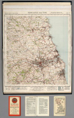
Great Britain. Ordnance Survey
Full Title
Sheet 78. Newcastle upon Tyne.
Publisher
Ordnance Survey of Great Britain
Author
Great Britain. Ordnance Survey
Full Title
Sheet 82. Keswick.
Publisher
Ordnance Survey of Great Britain
Author
Great Britain. Ordnance Survey
Full Title
Sheet 83. Penrith.
Publisher
Ordnance Survey of Great Britain
Author
Great Britain. Ordnance Survey
Full Title
Sheet 84. Teesdale.
Publisher
Ordnance Survey of Great Britain
Author
Great Britain. Ordnance Survey
Full Title
Sheet 85. Durham.
Publisher
Ordnance Survey of Great Britain
Author
Great Britain. Ordnance Survey
Full Title
Sheet 86. Redcar and Whitby.
Publisher
Ordnance Survey of Great Britain
Author
Great Britain. Ordnance Survey
Full Title
Sheet 87. Isle of Man. (also known as Sheet 17).
Publisher
Ordnance Survey of Great Britain
Author
Great Britain. Ordnance Survey
Full Title
Sheet 88. Barrow in Furness.
Publisher
Ordnance Survey of Great Britain
Author
Great Britain. Ordnance Survey
Full Title
Sheet 89. Lancaster and Kendal.
Publisher
Ordnance Survey of Great Britain
Author
Great Britain. Ordnance Survey
Full Title
Sheet 90. Askrigg and Settle.
Publisher
Ordnance Survey of Great Britain
|