Who What Where WhenREMOVE |
Author
Appleton, D. & Co.
Full Title
Map of North Carolina and South Carolina. Copyright 1891 by Matthews-Northrup Co. ... Buffalo, New York. (inset) Map of Charleston Harbor and vicinity. (to accompany) The Library Atlas Of Modern Geography ... New York, D. Appleton And Company 1892. (on upper margin) North Carolina and South Carolina. 89.
Publisher
D. Appleton & Co.
Author
Appleton, D. & Co.
Full Title
Map of Ohio. Copyright 1891 by Matthews-Northrup Co. ... Buffalo, New York. (to accompany) The Library Atlas Of Modern Geography ... New York, D. Appleton And Company 1892. (on upper margin) Ohio. 90.
Publisher
D. Appleton & Co.
Author
Appleton, D. & Co.
Full Title
Map of Cleveland, Ohio. Copyright 1891 by Matthews-Northrup Co. ... Buffalo, New York. (to accompany) The Library Atlas Of Modern Geography ... New York, D. Appleton And Company 1892. (on upper margin) Cleveland. 91.
Publisher
D. Appleton & Co.
Author
Appleton, D. & Co.
Full Title
Map of Cincinnati, Ohio. Copyright 1891 by Matthews-Northrup Co. ... Buffalo, New York. (to accompany) The Library Atlas Of Modern Geography ... New York, D. Appleton And Company 1892. (on upper margin) Cincinnati. 92.
Publisher
D. Appleton & Co.
Author
Appleton, D. & Co.
Full Title
Map of Pennsylvania. Copyright 1891 by Matthews-Northrup Co. ... Buffalo, New York. (to accompany) The Library Atlas Of Modern Geography ... New York, D. Appleton And Company 1892. (on upper margin) Pennsylvania. 93.
Publisher
D. Appleton & Co.
Author
Appleton, D. & Co.
Full Title
Map of Philadelphia, Penn. Copyright 1891 by Matthews-Northrup Co. ... Buffalo, New York. (to accompany) The Library Atlas Of Modern Geography ... New York, D. Appleton And Company 1892. (on upper margin) Philadelphia 94.
Publisher
D. Appleton & Co.
Author
Appleton, D. & Co.
Full Title
Map of Pittsburg and Allegheny, PA. Copyright 1891 by Matthews-Northrup Co. ... Buffalo, New York. (to accompany) The Library Atlas Of Modern Geography ... New York, D. Appleton And Company 1892. (on upper margin) Pittsburg and Allecheny 95.
Publisher
D. Appleton & Co.
Author
Appleton, D. & Co.
Full Title
Map of Rhode Island. Copyright 1891 by Matthews-Northrup Co. ... Buffalo, New York. (insets) City of Providence. (with) City of Newport. (to accompany) The Library Atlas Of Modern Geography ... New York, D. Appleton And Company 1892. (on upper margin) Rhode Island 96.
Publisher
D. Appleton & Co.
Author
Appleton, D. & Co.
Full Title
Map of South Dakota and North Dakota. Copyright 1891 by Matthews-Northrup Co. ... Buffalo, New York. (to accompany) The Library Atlas Of Modern Geography ... New York, D. Appleton And Company 1892. (on upper margin) South Dakota and North Dakota 97
Publisher
D. Appleton & Co.
Author
Appleton, D. & Co.
Full Title
Map of Texas, Oklahoma and Indian Territory. Copyright 1891 by Matthews-Northrup Co. ... Buffalo, New York. (inset) Western part of Texas. (to accompany) The Library Atlas Of Modern Geography ... New York, D. Appleton And Company 1892. (on upper margin) Texas, Oklahoma and Indian Territory 98.
Publisher
D. Appleton & Co.
Author
Appleton, D. & Co.
Full Title
Map of Utah. Copyright 1891 by Matthews-Northrup Co. ... Buffalo, New York. (to accompany) The Library Atlas Of Modern Geography ... New York, D. Appleton And Company 1892. (on upper margin) Utah 99.
Publisher
D. Appleton & Co.
Author
Appleton, D. & Co.
Full Title
Map of Washington and Oregon. Copyright 1891 by Matthews-Northrup Co. ... Buffalo, New York. (to accompany) The Library Atlas Of Modern Geography ... New York, D. Appleton And Company 1892. (on upper margin) Washington and Oregon 100.
Publisher
D. Appleton & Co.
Author
Appleton, D. & Co.
Full Title
Map of Virginia, West Virginia, Maryland and Delaware. Copyright 1891 by Matthews-Northrup Co. ... Buffalo, New York. (insets) District of Columbia. (with) Part of Lee County, Virginia. (to accompany) The Library Atlas Of Modern Geography ... New York, D. Appleton And Company 1892. (on upper margin) Virginia, West Virginia, Maryland and Delaware 101
Publisher
D. Appleton & Co.
Author
Appleton, D. & Co.
Full Title
Map of Baltimore, Maryland. Copyright 1891 by Matthews-Northrup Co. ... Buffalo, New York. (to accompany) The Library Atlas Of Modern Geography ... New York, D. Appleton And Company 1892. (on upper margin) Baltimore. 102.
Publisher
D. Appleton & Co.
Author
Bowen, Emanuel
Full Title
A new & accurate map of Bermudas or Sommer's Islands ... ; An accurate map of the Island of St. Christopher, vulgarly called St. Kits ... By Eman. Bowen. (London: Printed for William Innys, Richard Ware, Aaron Ward, J. and P. Knapton, John Clarke, T. Longman and T. Shewell, Thomas Osborne, Henry Whitridge ... M.DCC.XLVII)
Publisher
William Innys [et al.]
Author
Appleton, D. & Co.
Full Title
Map of Washington, D.C. Copyright 1891 by Matthews-Northrup Co. ... Buffalo, New York. (to accompany) The Library Atlas Of Modern Geography ... New York, D. Appleton And Company 1892. (on upper margin) Washington. 102.
Publisher
D. Appleton & Co.
Author
Beers, J.H. & Co.
Full Title
Map of Franklin County.
Publisher
J.H. Beers
Author
Beers, J.H. & Co.
Full Title
Brookville.
Publisher
J.H. Beers
Author
Beers, J.H. & Co.
Full Title
Cedar Grove Formerly Rochester, Peppertown, New Trenton, South Gate, Scipio, Drewersburg (Laid Out as Edinburg).
Publisher
J.H. Beers
Author
Beers, J.H. & Co.
Full Title
Map of Metamora Township. Metamora. St. Mary's, Haymond P.O. St. Philomena, Oak Forest P.O.
Publisher
J.H. Beers
Author
Beers, J.H. & Co.
Full Title
Map of Brookville Township, Franklin County, Indiana. Fairfield. Union, Whitcomb P.O., Indiana.
Publisher
J.H. Beers
Author
Beers, J.H. & Co.
Full Title
Map of Springfield Township.
Publisher
J.H. Beers
Author
Beers, J.H. & Co.
Full Title
Map of Bath Township. Map of Fairfield Township.
Publisher
J.H. Beers
Author
Beers, J.H. & Co.
Full Title
Map of Blooming Grove Township. Blooming Grove. Mixerville.
Publisher
J.H. Beers
Author
Beers, J.H. & Co.
Full Title
Map of Laurel Township.
Publisher
J.H. Beers
Author
Beers, J.H. & Co.
Full Title
Map of Posey Township. Andersonville (Formerly Ceylon), Mt. Carmel, Buena Vista, Hamburg, and Palestine.
Publisher
J.H. Beers
Author
Beers, J.H. & Co.
Full Title
Laurel.
Publisher
J.H. Beers
Author
Beers, J.H. & Co.
Full Title
Map of Salt Creek Township.
Publisher
J.H. Beers
Author
Beers, J.H. & Co.
Full Title
Map of Ray Township. Oldenburg. Enochsburg. Huntersville.
Publisher
J.H. Beers
Author
Bowen, Emanuel
Full Title
A new & accurate map of the island of Cuba. Drawn from the most approved maps & charts ... ; A new & accurate map of the islands of Hispaniola or St. Domingo, and Porto Rico. Drawn from the most approved maps & charts ... By Eman. Bowen. (London: Printed for William Innys, Richard Ware, Aaron Ward, J. and P. Knapton, John Clarke, T. Longman and T. Shewell, Thomas Osborne, Henry Whitridge ... M.DCC.XLVII)
Publisher
William Innys [et al.]
Author
Beers, J.H. & Co.
Full Title
Map of Butler Township.
Publisher
J.H. Beers
Author
Beers, J.H. & Co.
Full Title
Map of Highland Township. Village and Catholic Church of St. Peter.
Publisher
J.H. Beers
Author
Beers, J.H. & Co.
Full Title
Map of White Water Township.
Publisher
J.H. Beers
Author
Beers, J.H. & Co.
Full Title
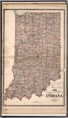
Sectional and Township Map of Indiana. 1882.
Publisher
J.H. Beers
Author
Beers, J.H. & Co.
Full Title
New Railroad Map of the United States.
Publisher
J.H. Beers
Author
Beers, J.H. & Co.
Full Title
Western Hemisphere. Eastern Hemisphere.
Publisher
J.H. Beers
Author
Pinkney & Brown
Full Title
Outline Map of Saint Croix County, Wisconsin
Publisher
F. Bourquin
Author
Pinkney & Brown
Full Title
Plat of Cady.
Publisher
F. Bourquin
Author
Pinkney & Brown
Full Title
Plat of Springfield.
Publisher
F. Bourquin
Author
Pinkney & Brown
Full Title
Plat of Glenwood.
Publisher
F. Bourquin
Author
Pinkney & Brown
Full Title
Plat of Forest.
Publisher
F. Bourquin
Author
Pinkney & Brown
Full Title
Plat of Eau Galle.
Publisher
F. Bourquin
Author
Pinkney & Brown
Full Title
Plat of Baldwin.
Publisher
F. Bourquin
Author
Pinkney & Brown
Full Title
Plat of Emerald.
Publisher
F. Bourquin
Author
Pinkney & Brown
Full Title
Plat of Cylon.
Publisher
F. Bourquin
Author
Pinkney & Brown
Full Title
(Plat of) Pleasant Valley. (Plat of) Rush River.
Publisher
F. Bourquin
Author
Pinkney & Brown
Full Title
Plat of Hammond.
Publisher
F. Bourquin
Author
Pinkney & Brown
Full Title
Plat of Erin.
Publisher
F. Bourquin
Author
Pinkney & Brown
Full Title
Plat of Stanton.
Publisher
F. Bourquin
|